Bottom Contact
Bulk carrier Kaministiqua
Kahnawake, Québec
The Transportation Safety Board of Canada (TSB) investigated this occurrence for the purpose of advancing transportation safety. It is not the function of the Board to assign fault or determine civil or criminal liability. This report is not created for use in the context of legal, disciplinary or other proceedings. See Ownership and use of content. Masculine pronouns and position titles may be used to signify all genders to comply with the Canadian Transportation Accident Investigation and Safety Board Act (S.C. 1989, c. 3).
Description of the vessels
The Kaministiqua (International Maritime Organization No. 8119285, Figure 1) is a 222.54 m-long and 23.17 m-wide bulk carrier, registered in Canada and owned by Lower Lakes Towing Ltd. It was built in 1983 and is equipped with a single controllable pitch propeller housed in a steerable Kort nozzle, and a bow thruster.

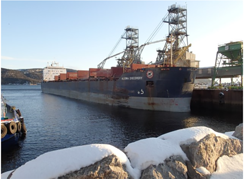
The Algoma Discovery (International Maritime Organization No. 8505848; Figure 2) is a 222.4 m-long and 23.14 m-wide bulk carrier, registered in Canada and owned by Algoma Central Corporation. The vessel was built in 1987 and is equipped with a controllable pitch propeller and a bow thruster.
History of the voyage
Kaministiqua
On 26 November 2019, at 2205,Footnote 1 the Kaministiqua departed from Sorel, Quebec in ballast, for Thunder Bay, Ontario, under the conduct of a pilot. The vessel’s forward draft was 5.18 m, and its aft draft was 7.01 m.
On 27 November 2019, at 0319, the Kaministiqua arrived at the Saint-Lambert Lock, which is the first lock located at the entrance to the South Shore Canal of the St. Lawrence Seaway. The pilot from the Laurentian Pilotage Authority handed conduct of the vessel to the master and subsequently disembarked. At 0339, the vessel departed from the lock.
Algoma Discovery
On 26 November 2019, at 0144, the Algoma Discovery, loaded with 25 200 tonnes of soya beans in bulk, departed from Johnstown, Ontario, for Baie-Comeau, Quebec. The vessel’s forward draft was 8.1 m and its aft draft was 8.14 m.
On 27 November 2019, the vessel was proceeding downbound in the St. Lawrence Seaway with the vessel under the conduct of the master. At 0514, the vessel departed from the lower lock in Beauharnois, Quebec. The bridge team consisted of the master, a helmsman, and a third officer as officer of the watch (OOW).
Meeting sequence and bottom contact
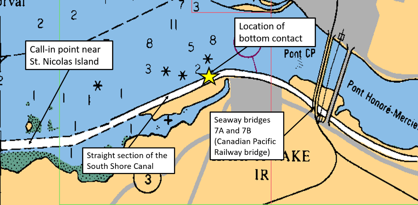
At 0540, the Kaministiqua departed from the Côte-Sainte-Catherine Lock. The bridge team consisted of the master, a helmsman, and the chief officer as OOW. As the vessel exited the lock, the master of the Kaministiqua contacted the master of the Algoma Discovery, who proposed that the vessels meet and pass somewhere in the straight section of the South Shore Canal, upstream of Seaway bridges 7A and 7B, which is the Canadian Pacific Railway bridge at Kahnawake, Quebec (Figure 3). The master of the Kaministiqua agreed to the proposal. Some time later, the master of the Kaministiqua called the Seaway traffic controller on VHF radiotelephone and arranged to pass under Seaway bridges 7A and 7B, between 0611 and 0654.Footnote 2
Around 0606, the Kaministiqua passed the Côte-Sainte-Catherine Wharf at a reduced speed of 3.5 knots. The speed reduction was required by the Seaway traffic controller to accommodate 3 vessels that were moored at the wharf.
At 0610, the master of the Algoma Discovery called the master of the Kaministiqua on VHF radiotelephone to confirm that the meeting would take place upstream of bridges 7A and 7B in the straightaway to the west of the curve.Footnote 3
Around 0614, the master of the Algoma Discovery made another VHF call to the master of the Kaministiqua, and suggested that the Kaministiqua increase its speed. The Algoma Discovery’s speed at the time of the call was 6.9 knots. However, the Kaministiqua maintained its speed of 5.9 knots.
At about 0617, the Algoma Discovery made a VHF call to the Seaway traffic controller, to report that it had just passed its call-in point near Saint-Nicolas Island. The master then arranged with the Seaway traffic controller for the vessel to pass under Seaway bridges 7A and 7B between 0654 and 0700.
At 0629, the Algoma Discovery entered the South Shore Canal and broadcast a security call to nearby vessels on VHF, announcing that the Algoma Discovery was entering the South Shore Canal, eastbound. The vessel’s speed was 4.9 knots.
Meanwhile, the Kaministiqua approached Seaway bridges 7A and 7B at a speed of 5.9 knots, and passed under them at 0634. Just before 0644, while rounding the curve, the vessel proceeded close to the north bank and then deviated toward the centre of the canal. To correct the deviation, the Kaministiqua altered course to starboard at 0646:18.
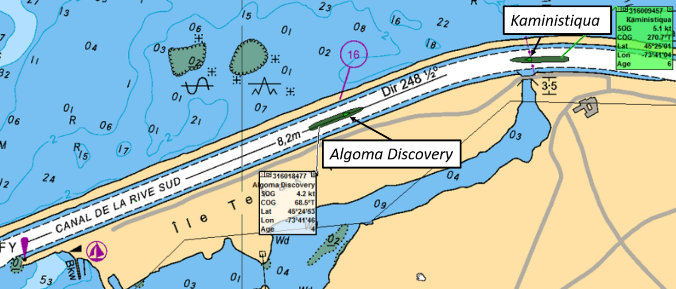
At 0646:23, as the Kaministiqua was altering its course away from the centre of the canal, the Algoma Discovery was approaching the curve at a speed of 4.9 knots. The Algoma Discovery was positioned close to the centre line of the canal, and the vessels were approximately 0.4 NM apart (Figure 4). The master of the Algoma Discovery made a VHF call to the Kaministiqua, requesting that it give the Algoma Discovery more room. The Kaministiqua did not acknowledge the Algoma Discovery’s call.
At 0647:45, the Kaministiqua altered its course to port to enter the straight section of the canal. Soon after, the master ordered the chief officer to monitor the distance from the vessel to the north shore of the canal.
At 0648:50, the 2 vessels were abeam each other (Figure 5). The Kaministiqua was slowly changing course to port, toward the centre of the canal. The Algoma Discovery was still positioned close to the canal’s centre line, just before the curve, and maintaining its course. While manoeuvring, the Kaministiqua’s starboard quarter came within approximately 7 m of the north bank of the canalFootnote 4 and the vessel made bottom contact. Seconds later, the vessels passed each other and continued their intended voyages.

Post-occurrence events and damage to the <em>Kaministiqua</em>
Bridge personnel on the Kaministiqua had no immediate indication that the vessel had touched bottom. At approximately 0700, the Kaministiqua developed a port list due to the loss of the starboard ballast water; damage to the starboard side ballast tank No. 6 was suspected.
At about 0710, the master of the Kaministiqua contacted the Seaway traffic control centre by cellphone to report the incident. The master reported that his vessel had not had enough room to meet and pass the Algoma Discovery, and that bank suction effect had contributed to the vessel’s bottom contact and suspected damage. The Seaway traffic controller authorized the Kaministiqua to proceed to the locks at Beauharnois, Quebec, for examination.
At 1000, the Kaministiqua was secured on the north wall of the lock No. 4 in Beauharnois, Quebec. Authorities inspected the vessel later that day.
The following day, 28 November 2019, the vessel’s classification society reported that the Kaministiqua had sustained damage to its No. 6 starboard side hopper and double-bottom ballast tank. Temporary repairs were carried out before the vessel resumed its normal operations.
Environmental conditions
At the time of the occurrence on 27 November, the sky was overcast and visibility was about 10 NM. The wind was from the northeast at 5 to 10 knots, and the current was set in an easterly direction at a rate of 1 to 1.5 knots.Footnote 5 The air temperature was approximately 1 °C.
Personnel certification and experience
The master of the Kaministiqua had joined Lower Lakes Towing Ltd. in 2007. He held a Master, Near Coastal certificate of competency, and had been master on the Kaministiqua since 2016. He also possessed a Restricted Radio Operator’s Certificate (ROC-MC) and a valid pilotage certificate,Footnote 6 and had 10 years’ experience performing pilotage as a chief mate and then master in the St. Lawrence Seaway.
The master of the Algoma Discovery held a Master Mariner certificate of competency. He started sailing with the Algoma Central Corporation in 1989 and became a master in 2003. He possessed a RTR - Restricted RT Operator Certificate (old), a valid pilotage certificate, and had been performing pilotage as a master in the St. Lawrence Seaway since 2003.
Regulations applicable to vessels transiting the St. Lawrence Seaway
International Regulations for Preventing Collisions at Sea, Canadian Modifications
The International Regulations for Preventing Collisions at Sea (COLREGs) are an international convention that establishes, among other things, the rules of conduct at sea when a risk of collision exists between vessels. Rule 9(a) of the COLREGs indicates that a vessel proceeding along a narrow channel shall keep near to the outer limit of the channel on its starboard side.Footnote 7 This means vessels are to pass port-to-port.
The Canadian Modifications to the COLREGs require that, in a narrow channel where there is a current and 2 vessels are meeting from opposite directions, “the vessel proceeding with the current or tidal stream shall be the stand-on vessel and shall propose the place of passage […]”Footnote 8 and the side on which the vessel will pass. The Canadian Modifications further specify that vessels may use a bridge-to-bridge radiotelephone instead of the prescribed sound signals to reach agreement in a meeting.Footnote 9
As the Algoma Discovery was proceeding downbound as the stand-on vessel (i.e., with the current) along the South Shore Canal, it was required to propose meeting and passing arrangements to the Kaministiqua. While the masters of the 2 vessels did agree to a planned location of passage, they did not revise or update the plan as it became apparent that they would not meet in the agreed location.
St. Lawrence Seaway Management Corporation requirements
The St. Lawrence Seaway Management Corporation’s Seaway Handbook prescribes the maximum speeds allowed in the different Seaway sections. According to the handbook, the maximum speed in all canals, including the South Shore Canal, is 6 knots.Footnote 10 Vessels may travel at a higher speed, depending on their particulars and weather conditions, for short periods of time to ensure safe navigation.
In this occurrence, both the Kaministiqua and Algoma Discovery maintained speeds of under 6 knots while transiting the South Shore Canal. Although the Algoma Discovery requested that the Kaministiqua increase its speed, the Kaministiqua maintained its speed within the acceptable limit.
Vessels may also meet within the Seaway, except at places designated as no-meeting areas, or if otherwise instructed by the Seaway traffic controller.Footnote 11 Masters and pilots may arrange meetings of vessels, and the Seaway traffic controller may assist in such arrangements upon request. Two vessels may meet each other in the curve of the South Shore Canal, as the Kaministiqua and Algoma Discovery did in this occurrence. However, it is common practice for masters and pilots to meet in the canal’s 2 straight sections, either upstream or downstream of Seaway bridges 7A and 7B.
Navigation in narrow channels
When navigating in restricted waters, a vessel is subject to the following effects:
- In narrow channels a vessel tends to find the centre of the channel. A vessel approaching one bank of the channel tends to be pushed away by the build-up of water on that side, commonly referred to as bank cushion effect.
- Another effect is bank suction. This is caused by the asymmetrical flow of water around the vessel sailing in the proximity of one of the banks, which may pull it towards the bank.
- Vessels experience hydrodynamic interaction when passing or overtaking one another in close proximity. The interaction forces may cause an uncommanded yaw.Footnote 12, Footnote 13
These hydrodynamic effects may cause problems in manoeuvring, which can lead to grounding or collision. The Kaministiqua and Algoma Discovery were subject to these effects when transiting the Seaway, and the effects may have been amplified when the 2 vessels manoeuvred to meet and pass in the South Shore Canal.
VHF radiotelephone communications between the vessels
A few brief exchanges over VHF radiotelephone occurred between the master of the Kaministiqua and Algoma Discovery as they made their meeting and passing arrangements. The exchanges did not follow standardized bridge-to-bridge VHF radiotelephone communication procedures and phraseology as prescribed by Industry Canada’s Syllabus for the Restricted Operator’s Certificate – Maritime Commercial (ROC-MC).Footnote 14
In this occurrence, no communication occurred between the masters regarding their ability to meet at the intended passing point, given their vessels’ respective speeds and operational constraints. Once it became obvious that they would not be able to meet in the straight section of the canal, no communication occurred to update their plan. The lack of communication and explicit coordination between the vessels may have impaired the masters’ shared understanding of the situation.
Safety messages
Bridge teams must establish and implement comprehensive meeting and passing arrangements and communicate effectively to ensure a common understanding if circumstances change.
Additionally, it is important that bridge teams consider the hydrodynamic effects their vessels are subject to while navigating and manoeuvring in narrows such as the St. Lawrence Seaway.
This report concludes the Transportation Safety Board of Canada’s investigation into this occurrence. The Board authorized the release of this report on . It was officially released on .