Collision with power lines
Privately registered
Cessna 150M, C-GYEV
Les Cèdres, Quebec
The Transportation Safety Board of Canada (TSB) investigated this occurrence for the purpose of advancing transportation safety. It is not the function of the Board to assign fault or determine civil or criminal liability. This report is not created for use in the context of legal, disciplinary or other proceedings. See Ownership and use of content. Masculine pronouns and position titles may be used to signify all genders to comply with the Canadian Transportation Accident Investigation and Safety Board Act (S.C. 1989, c. 3).
History of the flight
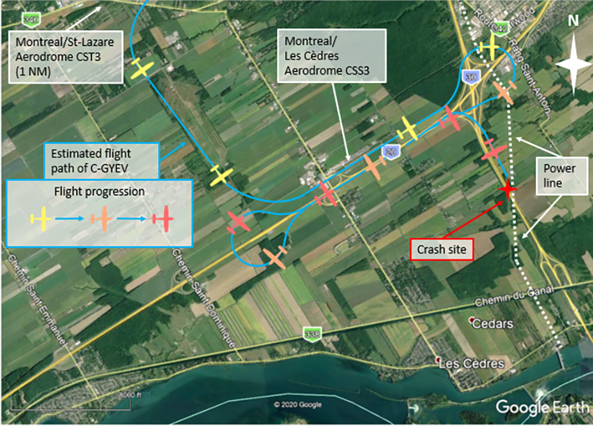
At approximately 1827Footnote 1 on 17 February 2020, a privately registered Cessna 150M (registration C‑GYEV, serial number 15078827), with a passenger seated on the right and the pilot seated on the left, took off from the Montréal/St‑Lazare Aerodrome (CST3), Quebec, for a night flight under visual flight rules (VFR). At approximately 1830, the aircraft conducted an approach to Runway 07 at the Montréal/Les Cèdres Aerodrome (CSS3), Quebec, followed by a pull-up. The aircraft then conducted a 180-degree turn over the interchange between Highway 20 and Highway 30 and flew westbound over Highway 20 at a very low altitudeFootnote 2 (Figure 1).
At approximately 1834, the aircraft conducted another 180-degree turn, flying eastbound over Highway 20 at a very low altitude. When it was close to the interchange between Highway 20 and Highway 30, the aircraft turned south and flew over Highway 30, still at a very low altitude. At approximately 1836, the aircraft struck power lines crossing Highway 30 at kilometer 7 and crashed to the ground. The 2 occupants received fatal injuries. The aircraft was destroyed. Numerous calls were made to 911 by individuals who witnessed the accident. Emergency services arrived quickly at the scene of the accident.
Weather information
According to the aerodrome routine meteorological report (METAR) issued at 1800 for the Montréal/Pierre Elliott Trudeau Intl Airport (CYUL), Quebec, 14 nautical miles northeast of the accident site, the weather was favourable for this VFR flight and was not considered to have contributed to the accident.
Pilot information
The pilot had a student pilot permit – aeroplane, issued 23 August 2017, and a valid Category 3 medical certificate. The pilot began initial training in 2017 and acquired the occurrence aircraft in October 2017. According to Transport Canada Civil Aviation (TCCA) records, the pilot’s training was never completed and no further requests were added to his file.
According to the Canadian Aviation Regulations (CARs),Footnote 3 a student pilot permit allows the holder to act as pilot-in-command if the following conditions are met:
- the flight is conducted for the purpose of the holder’s flight training;
- the flight is conducted in Canada;
- the flight is conducted under day VFR;
- the flight is conducted under the direction and supervision of a person qualified to provide training toward the permit, licence or rating for which the pilot-in command experience is required; and
- no passenger is carried on board.
The occurrence flight did not comply with the privileges conferred on a student pilot permit.
The passenger held a valid private pilot licence – aeroplane, issued in September 2015, and a valid Category 1 medical certificate. The passenger also held a night endorsement. However, the investigation determined that the passenger was not at the controls of the aircraft in the moments before the accident.
Aircraft information
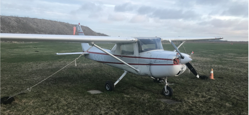
The occurrence aircraft was manufactured in 1976. It was certified, equipped and maintained in accordance with regulations in effect. According to the last annual report sent to TCCA in January 2020, the aircraft had accumulated 17 749 flight hours since its construction.
The aircraft had no known deficiencies before the flight. The aircraft did not have a recorder on board, and regulations in effect did not require that it have one.
The aircraft was equipped with a Kannad emergency locator transmitter (ELT), model 406 AF-compact, which transmitted on frequencies 121.5 MHz and 406 MHz. The last ELT inspection was conducted in April 2018; the maintenance interval applicable in this case was not to exceed 12 months according to the standardFootnote 4 in effect at the time of the accident. The ELT, its antenna and the associated cable were intact, and the ELT switch was in the armed position, but the investigation was unable to determine whether a signal was detected.
Accident site and examination of wreckage
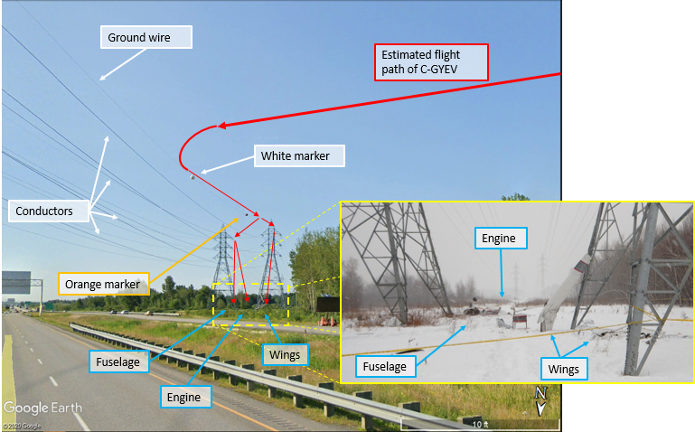
The accident occurred at kilometer 7 on Highway 30, where 2 parallel power lines, installed approximately 21.5 m (70 feet) from each other, cross the highway. These 2 power lines, which were struck by the aircraft, are operated by Hydro-Québec. The 1st point of impact was the power line ground wireFootnote 5 on the west side. This wire extends over the highway at a height no greater than 30 m (98 feet).
Impact marks on the tip of the aircraft’s left wing revealed that the initial impact occurred with a (white) marker installed on the ground wire. The dent in the wing observed between the wing strut and the cabin door led to the conclusion that following this 1st impact, the aircraft continued on its path, with the left wing sliding laterally along the ground wire and striking a 2nd (orange) marker, 75 m (246 feet) further.
As the aircraft continued to slide along the ground wire, the wire spliced the roof, which separated from the rest of the aircraft, and the aircraft broke into 2 parts:
- a part with the 2 wings, which continued along the ground wire until it struck the hydro tower 75 m (246 feet) beyond the orange marker and crashed to the ground;
- the rest of the aircraft (roofless fuselage), which was thrown more than 14 m (46 feet) further on the power line conductorFootnote 6 on the east side, before striking the tower on this line.
When the roofless fuselage struck the hydro tower, it separated into 2 other parts:
- the rear part of the fuselage and cabin, which struck the ground near the base of the hydro tower;
- the engine (nose of the aircraft), which struck the ground a bit further, bounced, then came to a rest on the ground.
Figure 3 shows the aircraft’s estimated path, as well as the markers and wires that were struck. It also provides an image of the crash site and wreckage.
The damage sustained by the propeller, and the damage to the power lines indicate that the engine was producing power at the time of impact. Furthermore, the investigation determined that the power lever was in the full power position at the time of the impact.
The power lines that the occurrence aircraft struck were indicated on the Montréal VFR navigation chart (VNC). In general, power lines are indicated on VNCs because they are useful markers that can facilitate visual navigation. The investigation was unable to determine whether the pilot had the Montréal VNC on hand or if he had consulted it before departure.
Marking of obstacles to air navigation
According to CARs subsection 601.24 (2),Footnote 7 marking and lighting are required for any building, structure or object that constitutes an obstacle to air navigation. The hydro towers at this location were double-circuit towers,Footnote 8 which were no higher than 40 m (131 feet) above ground level (AGL) and the wires were lower than the top of the towers. Although they were within a 6 km radius of CSS3, they were not an obstacle according to CARs,Footnote 9 given that their height did not exceed 90 m (296 feet) AGL.
Even though the CARs did not require marking at this location, the ground wire crossing Highway 30 was marked, but not lit. The markers had been installed at the request of a fuel company that had an underground pipeline passing through this location and performed day inspections by helicopter.
Low altitude flight
Intentionally flying at a low altitude increases the risk of an accident. The pilot’s field of vision is reduced at low altitude. Consequently, the pilot has less time to take action to avoid obstacles and terrain. It is also recognized that flying at low altitude reduces the margin of safety in the event of engine failure, a loss of control or any other unexpected circumstances, while increasing the risk of an impact with the ground or an obstacle.
The CARs stipulates that no person shall operate an aircraft “at a distance less than 500 feet from any person, vessel, vehicle or structure.”Footnote 10 This distance of 500 feet applies both vertically and horizontally.
Pursuant to the CARs, “[n]o person shall operate an aircraft in such a reckless or negligent manner as to endanger or be likely to endanger the life or property of any person.”Footnote 11
The TSB has recently investigated several occurrencesFootnote 12 for which this manoeuvre was identified as a contributing factor.
In this occurrence, 3 videos were posted by the passenger on Snapchat using the “My Story” feature.Footnote 13 The videos showed a night flight at a very low altitude over Highway 20 and Highway 30 a few moments before the accident.
Night flight
Night VFR flights expose pilots to a greater risk of an accident than day flights. The lower number of visual markers, combined with a reduced ability to see at night, makes it difficult to identify the terrain and obstacles to navigation.
Visual performance by the human eye is considerably reduced when lighting is poor. Even when conditions are ideal for a night VFR flight, including a brightly lit sky, a pilot’s visual acuityFootnote 14 may drop to 20/200 or less, which means that a person could see at 20 feet what they would normally see at 200 feet under daylight conditions.Footnote 15
The human eye takes on average 30 minutes to adjust to an environment with low lighting. During this period of adjustment, night vision is reduced. Bright lights can compromise the eye’s adjustment to night vision. That is why pilots are advised to maintain the lighting on their instrument panel at a low setting and to not expose themselves to bright lighting just before takeoff. Also, any lighting in the cabin may be reflected in the windshield and interfere with the pilot’s visibility while flying.
In this occurrence, the collision with the wires occurred approximately 9 minutes after takeoff.
Safety messages
The pilot flying in this accident did not have a pilot’s licence or a night rating. Pilots who have not completed the training required to obtain a licence may not have acquired the skills or the decision-making abilities needed to safely conduct a flight.
Low altitude flights always present higher risks, and those risks are further increased at night, when visibility is limited. When flying at a low altitude, it is not easy to recognize and avoid obstacles such as wires, which may be extremely difficult to see. Pilots must be aware of these risks and fly within the prescribed limits.
This report concludes the Transportation Safety Board of Canada’s investigation into this occurrence. The Board authorized the release of this report on . It was officially released on .