Near collision with terrain on final instrument approach
Air Creebec Inc.
Boeing of Canada Ltd. De Havilland Division DHC-8-106, C-FLSX
Val-d’Or Airport (CYVO), Quebec
The Transportation Safety Board of Canada (TSB) investigated this occurrence for the purpose of advancing transportation safety. It is not the function of the Board to assign fault or determine civil or criminal liability. This report is not created for use in the context of legal, disciplinary or other proceedings. See Ownership and use of content. Masculine pronouns and position titles may be used to signify all genders to comply with the Canadian Transportation Accident Investigation and Safety Board Act (S.C. 1989, c. 3).
Summary
At 1525 Eastern Daylight Time on 26 October 2023, the Boeing of Canada Ltd. De Havilland Division DHC-8-106 aircraft (registration C-FLSX, serial number 285) operated by Air Creebec Inc. began an instrument flight rules flight from Chisasibi Airport (CSU2), Quebec, to Val-d’Or Airport (CYVO), Quebec, with 2 flight crew members, 1 cabin crew member, and 28 passengers on board. A few moments after beginning a descent from flight level 200, the flight crew received an instruction to hold at the initial approach waypoint IKDOB because an aircraft was going to land at CYVO before them.
The occurrence aircraft had been holding at 6000 feet above sea level for 12 minutes when it was cleared to conduct an area navigation approach to Runway 18 at CYVO using the global navigation satellite system. The aircraft exited the hold and ended up on a track that diverged from the approach. The pilot not flying reprogrammed the flight management system to rejoin the approach. A 2nd track divergence occurred at the final approach waypoint and, after terrain awareness and warning system alerts sounded, the flight crew conducted a go-around. The aircraft ended up 405 feet above ground level, 0.98 nautical miles to the right of the final approach path and 1.46 nautical miles from the runway threshold. A 2nd approach was conducted, and the aircraft landed on Runway 18 without further incident.
1.0 Factual information
1.1 History of the flight
At 0949All times are Eastern Daylight Time (Coordinated Universal Time minus 4 hours). on 26 October 2023, a Boeing of Canada Ltd. De Havilland Division DHC-8-106 aircraft operated by Air Creebec Inc. (Air Creebec) began a series of 5 flights from Montréal/Pierre Elliott Trudeau International Airport (CYUL),All locations are in the province of Quebec, unless otherwise indicated. with an estimated return time of 2015.
At 1525, the aircraft left Chisasibi Airport (CSU2) to conduct the 3rd flight, under instrument flight rules, to Val-d’Or Airport (CYVO). Two flight crew members, 1 cabin crew member, and 28 passengers were on board. During this occurrence flight, the captain was the pilot not flying (PNF) and the first officer, seated on the right, was the pilot flying (PF).
A few moments after leaving flight level 200, the Montréal Area Control Centre (ACC) told the flight crew that a priority medical evacuation (MEDEVAC) flight was going to land at CYVO before them. The ACC instructed the flight crew to proceed directly to the initial approach waypoint IKDOB and conduct the published hold. The PNF set the DTO [direct to] function for the initial approach waypoint IKDOB, and the flight management system (FMS) navigated the aircraft directly to IKDOB (the 5th item on the flight plan). Two other IKDOB waypoints were on the FMS flight plan: one at the beginning of the approach (the 7th item on the flight plan), and one at the end of the missed approach (the 12th item on the flight plan).
When the PNF attempted to add a holding pattern at the IKDOB waypoint before the approach (the 5th item on the flight plan), by default, the FMS suggested the preprogrammed hold at the IKDOB waypoint at the end of the missed approach (the 12th item on the flight plan) (see section 1.6.4.2 Holding pattern page). The PNF then activated the DTO HOLD [direct to hold] function at the bottom left of this page. Unbeknownst to the flight crew, the FMS navigated the aircraft to the IKDOB missed approach hold waypoint, which corresponded to the final waypoint on the flight plan (the 12th item on the flight plan).
The expected approach time was 1705 and, based on the amount of fuel on board, the aircraft could remain in the hold for approximately 20 minutes before needing to proceed to the alternate airport, CYUL. The PNF contacted Air Creebec dispatch to change the alternate airport from CYUL to Chibougamau/Chapais (CYMT). Given that CYMT was the next destination and closer than CYUL, this change allowed the occurrence aircraft to remain in the hold about 25 minutes longer, for a total of approximately 45 minutes.
At 1700, the aircraft entered the holding pattern at 6000 feet above sea level (ASL), and at that time, another aircraft entered the holding pattern at the IKDOB waypoint at 7000 feet ASL. At the same time, the MEDEVAC aircraft that was conducting an approach for Runway 36 executed a go-around because the weather conditions prevented the flight crew from seeing the runway. The MEDEVAC aircraft informed the ACC that it was not ready to conduct another approach immediately, and the ACC instructed it to enter a hold approximately 20 nautical miles (NM) west of CYVO to allow other aircraft to conduct an approach for Runway 18 at CYVO.
At 1711:35, the ACC cleared the occurrence flight crew to conduct an area navigation approach to Runway 18 using the global navigation satellite system (RNAV [GNSS] RWY 18 approach) and asked the flight crew to confirm if they could proceed directly to the approach from their position or if they needed to fly another circuit in the holding pattern. The flight crew confirmed that they could proceed directly to the approach.
The ACC then instructed the flight crew to switch to the mandatory frequency (118.5 MHz), then return to the current frequency to report when they were descending below 5000 feet ASL. These communications lasted 30 seconds and ended when the aircraft was 7 seconds from the IKDOB waypoint and still at 6000 feet ASL, which was 1590 feet above the approach slope. During these communications, the PNF set the PROCEED [proceed to] function in the FMS to exit the holding pattern the next time the IKDOB waypoint was passed. The FMS consists of 2 synchronized systems. Activating the PROCEED function generated messages on both systems that required acknowledgment from the PNF and the PF. The PF acknowledged the message just before passing the IKDOB waypoint, and the PNF acknowledged it just after.
At 1712:12, the aircraft passed the IKDOB waypoint that corresponded to the 12th item on the flight plan: that is, the last missed approach waypoint. Having reached the final waypoint on the flight plan, the FMS maintained the aircraft on its current course, which diverged from the final approach path by 48°. The PNF attempted to use the instrument landing system, but given that CYVO’s very high frequency omnidirectional range distance measuring equipment was not working, the PNF reprogrammed and activated the RNAV (GNSS) RWY 18 approach in the FMS. When the approach was activated, the FMS synchronized the aircraft’s heading with the CMD HDG [command heading] function and maintained the current course while waiting for the PNF to confirm the heading entered using the CMD HDG function. At that point, the PNF realized that the descent had not begun and entered 3900 feetAn altitude of 3900 feet is the minimum sector altitude that provides a 1000-foot obstacle clearance over all obstacles within a radius of at least 25 NM centred on final approach waypoint URVIX. in the altitude preselect controller so that the autopilot would level off at this altitude. However, the ALT SEL [altitude preselect] mode was not selected, and the aircraft did not level off.
At 1712:36, the PF began the descent at a fixed descent rate with the autopilot’s VS [vertical speed] mode. Power was not reduced. The airspeed gradually increased from 161 to 204 knots indicated airspeed (KIAS), at which point the power was reduced to the minimum. In the meantime, the PNF again attempted to establish a track to intercept the final approach path in the FMS and selected the heading proposed by the CMD HDG function in the FMS, which was the aircraft’s current heading.
At 1712:56, the autopilot HDG [heading] mode was engaged (without the FMS) to begin the left turn toward final approach waypoint URVIX. The aircraft was then at 5550 feet ASL, 8.84 NM from the threshold of Runway 18, and 1.39 NM to the right of the final approach path.
Just before reaching URVIX, the course deviation indicatorSee section 1.6.2 Horizontal situation indicator in this report for further information on this subject. pointer began to move toward the centre. The flight crew selected the autopilot NAV [navigation] mode to intercept the final approach path. The aircraft then began a right turn and shifted from 0.24 NM to the right of URVIX, to 500 feet above the approach slope. The aircraft was flying at 180 KIAS in a clean configuration (flaps and landing gear retracted). The right turn continued, but the final approach path was never intercepted.
When the aircraft’s heading passed the desired track (182° magnetic), the PNF (who did not have the runway in sight) activated the DTO function in the FMS to turn left directly toward the runway.
At 1714:47, the engine power increased from idle (0%) to 43%. However, the aircraft continued to descend at a constant rate of approximately 1300 fpm, and its speed gradually increased from 171 to 187 KIAS until power was reduced to 20%.
At 1714:56, the aircraft began a left turn toward the runway.
At 1715:00, while the aircraft was 1200 feet above ground level (AGL), the PNF asked the ACC for clearance to conduct a go-around because of navigation problems. The exchange of communications continued for 32 seconds.
At 1715:05, the aircraft left the final approach obstacle clearance area laterally at 1085 feet AGL. A few seconds later, the aircraft crossed the 1000 foot AGL stabilized approach gate approximately 1 NM to the right of the approach path. It was travelling at 187 KIAS in a clean configuration.
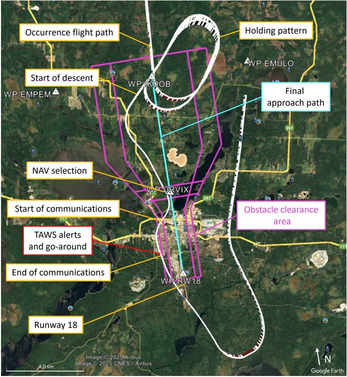
Around 6 seconds before communications ended, the terrain awareness and warning system (TAWS) generated alerts (Figure 1, and the FMS automatically displayed the page with information on an imminent collision with terrain.
The captain ordered a go-around and, at the same time, the PF disconnected the autopilot, increased the power to maximum, and pitched the aircraft in a nose-up attitude 1 second before communications ended with the ACC.
According to the flight data, the aircraft descended to 405 feet AGL when it was 0.96 NM to the right of the final approach path and 1.03 NM from the runway threshold, while still in a clean configuration and at 192 KIAS. The flight crew did not notice how close the aircraft was to the ground. The flight crew began the missed approach procedure and was cleared to conduct the RNAV (GNSS) RWY 18 approach a 2nd time using waypoint EMULO. The 2nd approach was completed without incident, and the aircraft landed at 1729.
1.2 Injuries to persons
There were no injuries.
1.3 Damage to aircraft
The aircraft was not damaged.
1.4 Other damage
There was no other damage.
1.5 Personnel information
Captain | First officer | |
|---|---|---|
Pilot licence | Airline transport pilot licence (ATPL) | Commercial pilot licence (CPL) |
Medical expiry date | 01 July 2024 | 01 December 2024 |
Total flying hours | 10 651 | 1492 |
Flight hours on type | 9246 | 245 |
Flight hours in the 24 hours before the occurrence | 3.2 | 3.2 |
Flight hours in the 7 days before the occurrence | 3 | 14 |
Flight hours in the 30 days before the occurrence | 50 | 58 |
Flight hours in the 90 days before the occurrence | 107 | 160 |
Flight hours on type in the 90 days before the occurrence | 104 | 157 |
Hours on duty before the occurrence | 7.25 | 7.25 |
Hours off duty before the work period | 12 | 38 |
The flight crew held the appropriate licences and ratings for the flight in accordance with existing regulations.
The captain had been employed by Air Creebec flying DHC-8 aircraft as a first officer since 2006 and as a captain since 2020.
The first officer had been employed by Air Creebec since April 2023. The first officer had completed initial training and successfully completed the pilot proficiency check on the DHC-8 in May 2023.
1.6 Aircraft information
The DHC-8-106 is a high-wing pressurized twin-engine turboprop aircraft equipped with retractable landing gear. The occurrence aircraft is certified to carry a flight crew of 2 pilots. At the time of the occurrence, it was configured to be able to carry up to 37 passengers, with at least 1 cabin crew member.
Manufacturer | Boeing of Canada Ltd. De Havilland Division* |
|---|---|
Type, model, and registration | DHC-8-106, C-FLSX |
Year of manufacture | 1991 |
Serial number | 285 |
Certificate of airworthiness issue date | 07 March 2007 |
Total airframe time | 51 278.3 hours |
Engine type (number of engines) | Pratt & Whitney Canada PW121 (2) |
Propeller type (number of propellers) | Hamilton Standard 14SF-7 (2) |
Maximum allowable take-off weight | 36 300 lb (16 465.7 kg) |
Recommended fuel types | Jet A, Jet A1, Jet B, JP-4, JP-5, JP-8 |
Fuel type used | Jet A1 |
* De Havilland Aircraft of Canada currently holds the type certificate for the aircraft type.
The aircraft was maintained in accordance with a maintenance schedule approved by Transport Canada.Air Creebec Inc., Maintenance Schedule Dash-8-100 P0285T Revision V5 #2 (25 April 2024). There were no recorded defects outstanding at the time of the occurrence. There was no indication that a component or system malfunction played a role in this occurrence.
The aircraft’s weight and centre of gravity were within the prescribed limits.
1.6.1 Maximum operating speeds
According to the occurrence aircraft flight manual,De Havilland Aircraft of Canada Limited, Airplane Flight Manual PSM 1-81-1A, DHC-8 Series 100, Model 106, Approved Flight Manual (11 March 2022), section 2.4.1, p. 2-4-1. the landing gear maximum operating speed (Vlo) is 158 KIAS. The maximum speeds with flaps extended (Vfe) are indicated below, based on the flap configuration:
Flap configuration | Maximum speed (KIAS) |
|---|---|
Flaps at 5° | 148 |
Flaps at 15° | 148 |
Flaps at 35° | 130 |
1.6.2 Horizontal situation indicator
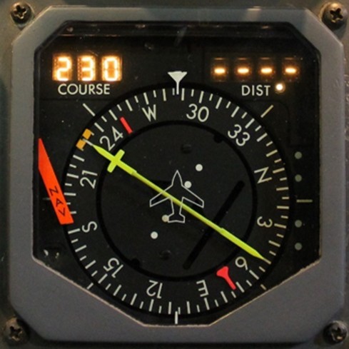
The horizontal situation indicator (HSI) (Figure 2) has numerous displays, which, together, present the aircraft’s displacement relative to the selected navigational course. The HSI route can be selected by turning the COURSEDe Havilland Aircraft of Canada Limited, Dash 8 Operating Data PSM 1-8-1, (30 September 2003), Chapter 14: Flight Instruments, System Description, Horizontal Situation Indicator, pp. 14.20.13 and 14.20.14. selector knob. When FMS navigation is selected, the course of the active route in the FMS is automatically selected on the HSI. The course deviation indicator in the centre represents the centre of the selected track. The slope indicator appears on the right when the selected approach mode also has a slope (not visible in the photo).
In this occurrence, when the approach was activated (ACT APPR), after leaving the holding pattern at IKDOB, both the PF’s and the PNF’s HSIs were lined up with the final approach course (182°). The occurrence aircraft did not have a navigation screen showing the aircraft’s position on a map.
1.6.3 Autopilot modes
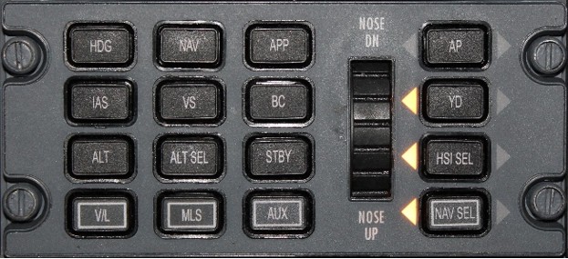
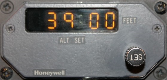
Various autopilot modes can be selected using the flight guidance controller panel (Figure 3), which is located on the glareshield panel. HDG [heading] mode activates lateral guidance commands based on the selected heading, which is displayed on the HSI. NAV [navigation] mode activates the lateral guidance commands to intercept and maintain the selected navigation course displayed on the HSI. VS [vertical speed] mode maintains a constant climb or descent rate, which is adjusted with the pitch thumb wheel on the flight guidance controller panel. ALT SEL [altitude preselect] mode activates vertical commands to maintain the preselected altitude displayed on the altitude preselect controller (Figure 4).
ALT [altitude hold] mode activates vertical commands to maintain the altitude at which the aircraft is flying when this mode is engaged. ALT mode is engaged automatically when ALT SEL mode is activated in the autopilot and the aircraft has reached the altitude selected in the altitude preselect controller.Ibid., Chapter 7: Automatic Flight, System Description, pp. 07.10.1 to 07.10.4. When there is a change in the target altitude, the PNF generally changes the altitude on the altitude preselect controller while the PF activates the ALT SEL mode on the flight guidance controller panel.
1.6.3.1 Altitude alerting system
The altitude alerting system helps pilots intercept the selected altitude and stay at that altitude. When the aircraft reaches a point 1000 feet from the altitude selected on the altitude preselect controller, the altimeter light illuminates and an aural alert can be heard. The light turns off 250 feet from the selected altitude. Then, if the altitude deviates more than 250 feet from the selected altitude, the light illuminates, and another aural alert may be heard depending on the options installed. The occurrence aircraft did not have this option; therefore, aural alerts were not generated.
1.6.4 Flight management system
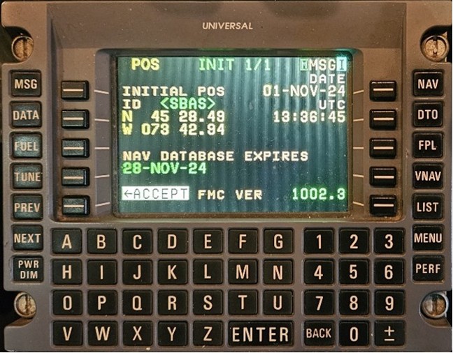
Like all Air Creebec Dash-8s, the occurrence aircraft had 2 UNS-1Lw FMSs manufactured by Universal Avionics, with version 1002.3 of the pilot software. These FMSs operate in synchronized mode, allowing each pilot to check and amend the flight plan as needed. They have a flat control and display panel (Figure 5) where the flight plan waypoints, among other things, are displayed. This panel is also used to program modifications to the FMS flight plan.
Thirteen aircraft in the Air Creebec fleet have an analog attitude indicator and a traditional HSI. Six aircraft are configured with an electronic flight instrument system, which includes an electronic attitude director indicator and an electronic horizontal situation indicator. The electronic flight instrument system displays limited information on the approach path. Two aircraft have a navigation screen that provides a visual depiction of the route defined in the FMS, along with holding patterns, approach paths, and some of the other aircraft operating within the navigation screen display distance.
The occurrence aircraft did not have a navigation screen, so the FMS active course was visible only on the HSI (see section 1.6.2 Horizontal situation indicator).
1.6.4.1 Flight plan pages
The FMS flight plan is presented on the FMS control and display panel. Because of its length, the flight plan is displayed over several pages (flight plan pages FPL 1/ 4 to FPL 4/ 4).
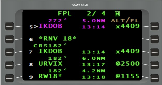
On the occurrence flight, the FMS was navigating directly to waypoint IKDOB, the 5th item on the flight plan, displayed in magenta in the top left of the screen on page FPL 2/ 4 (Figure 6). Magenta indicates an active waypoint—in other words, the next waypoint to be flown over. The next item (*RNV 18*) was the start of the approach, followed by the 7th item on the flight plan, the IKDOB waypoint after the start of the approach in the FMS (Figure 6).
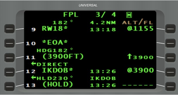
Page FPL 3/ 4 of the FMS flight plan (Figure 7) had a 3rd IKDOB waypoint (the 12th item on the flight plan) at the end of the missed approach, at which a hold was preprogrammed.
1.6.4.2 Holding pattern page
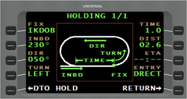
When the MNVR [manoeuvre] function is selected from the main navigation page (NAV 1/3), the holding pattern definition page (HOLDING 1/1) is displayed by default (Figure 8) if the FMS flight plan contains a holding pattern.
On the occurrence flight, when the flight crew attempted to add a holding pattern at the IKDOB waypoint before the approach (at the 5th item on the flight plan), by default, the FMS suggested the IKDOB waypoint corresponding to the 12th item on the flight plan, which was associated with the holding pattern preprogrammed at the last missed approach waypoint on the RNAV (GNSS) RWY 18 approach. When the holding pattern definition page was displayed, there was no indication of which of the 3 IKDOB waypoints on the flight plan was being used by the FMS.
If a flight crew activates the DTO HOLD [direct to hold] function on this page (bottom left on Figure 8) to fly directly to the holding pattern defined at IKDOB without changing the default waypoint, the FMS will navigate directly to the final IKDOB waypoint (12th item on the flight plan), at the end of the missed approach.
1.6.4.3 Navigation pages
The main navigation page (NAV 1/3) is generally displayed during the various stages of the flight.
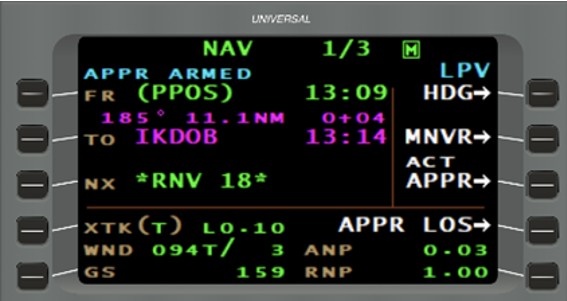
When the occurrence flight proceeded directly to IKDOB before the holding pattern was programmed, the main navigation page was displaying a route from the present position (PPOS) to IKDOB (the 5th item on the flight plan). The next item, *RNV 18*, indicated the start of the RNAV (GNSS) RWY 18 approach.
The blue indication of APPR ARMED [approach armed] mode at the top left of the screen meant that the approach was armed and would be automatically activated when the aircraft passed waypoint IKDOB (Figure 9).
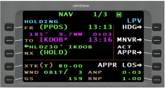
After the IKDOB holding pattern was programmed, the main navigation page still displayed PPOS to IKDOB, and the next waypoint was replaced by the holding pattern (HOLD) (Figure 10), meaning that the holding pattern would be flown at IKDOB.
The blue indication of HOLDING [holding pattern] mode at the top left of the screen meant that the FMS was in the holding pattern mode.
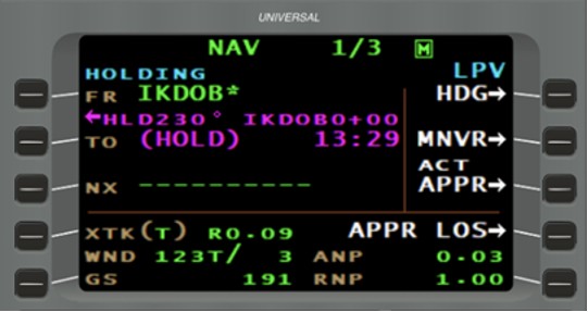
After the aircraft flew over waypoint IKDOB to enter the holding pattern, the main navigation page displayed from IKDOB to HOLD, and the next waypoint was replaced with dashes (Figure 11), indicating that there was no waypoint immediately after IKDOB.
One method to exit the holding pattern is to press MNVR [manoeuvre] (2nd button on the right in Figure 11).
The PROCEED [proceed to] function would then allow the FMS to continue navigating the flight plan after passing IKDOB (Figure 12).
After the PROCEED function was selected, the main navigation page still displayed from IKDOB to HOLD, and the dashes at the next waypoint were replaced by *NO LINK*, indicating that there was no waypoint immediately after the holding pattern at IKDOB (Figure 13).
*NO LINK* indicated a break in the FMS flight plan, meaning that there was no route segment after IKDOB. Consequently, the FMS was going to maintain the last holding pattern course (230°) just before *NO LINK*.
1.6.4.4 Heading selected mode
Pilots use the CMD HDG [command heading] function in the FMS to enter a heading and activate the HDG SEL [heading selected] mode in the FMS. When the CMD HDG function is selected (by pressing HDG, the 1st button on the right in Figure 13), the corresponding field is highlighted (Figure 14) until the pilot enters the desired heading and presses ENTER on the keyboard. The FMS then calculates the direction of the turn needed to achieve the desired heading and waits for confirmation from the pilot, who has to press ENTER a 2nd time for the heading to be available in HDG SEL mode in the FMS. If the heading entered intercepts the active route, the FMS displays the INTERCEPT function, which the pilot can select to have the FMS intercept the active route on the flight plan. Otherwise, the FMS displays NO INTCPT [no intercept] in grey (Figure 14).
The heading suggested in the entry field of the CMD HDG function in the FMS is synchronized with the aircraft’s heading in Air Creebec’s fleet of DHC‑8s, but never with the selected heading, which is displayed on the HSI.
1.6.4.5 Approach mode
The FMS approach mode can be activated from the main navigation page (NAV 1/3) by selecting ACT APPR [activate approach], the 3rd button on the right in Figure 13. When ACT APPR is selected, the FMS automatically goes into HDG SEL mode and highlights the CMD HDG field on page NAV 1/4. The aircraft’s heading is automatically suggested in the entry field of the CMD HDG function (the 1st button on the right in Figure 14), and all that is left to do is to confirm the heading entered. On the occurrence flight, the aircraft’s heading when the approach was activated, as the aircraft was exiting the hold, did not intercept the final approach path. In that case, NO INTCPT replaced the INTERCEPT function (the 2nd button on the right in Figure 14).
1.6.4.6 Terrain awareness and warning system
A TAWS is an advanced ground proximity warning system (GPWS) that, in addition to the GPWS functions, includes terrain and obstacle detection, as well as warnings based on the aircraft’s current and predicted position. The system generates visual and aural alerts in the cockpit.Universal Avionic Systems Corporation, Terrain Awareness Warning System (TAWS) SCN 12.X Operator’s Manual (25 February 2010), Introduction General, p. 1. Normally, when TAWS alerts are generated, the date, time, position, and alert type are recorded.
1.7 Meteorological information
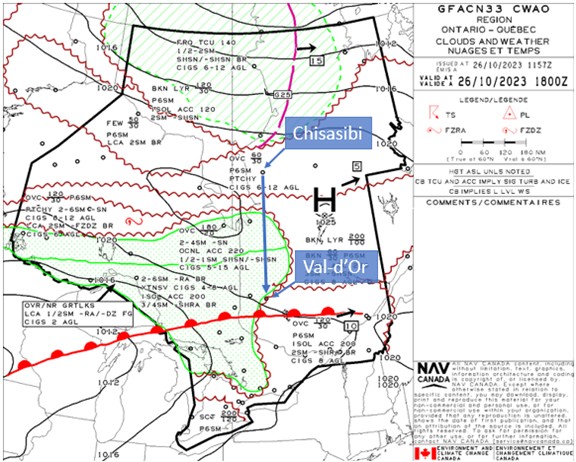
On the day of the occurrence flight, there was a warm front in the vicinity of CYVO, which was moving laterally east-northeast at 10 knots.
The Graphic Area Forecast Clouds and Weather chart for Ontario and Quebec, issued at 0757 and valid at 1400 on the day of the occurrence (Appendix A), indicated the following weather conditions for the Val-d’Or area:
- Overcast cloud layers from 3000 to 12 000 feet ASL
- Visibility greater than 6 statute miles (SM)
- Isolated altocumulus castellanus with tops at 20 000 feet AGL, providing visibility of 2 SM in light rain showers and mist, and an overcast ceiling at 800 feet AGL
In the morning, before departing CYUL, the flight crew received the aerodrome forecast (TAF) for CYVO, which had been issued at 0741 the day of the occurrence. This TAF indicated the following conditions from 0800:
- Winds from 030° true (T) at 5 knots
- Visibility of 1 SM in light rain, light drizzle, and mist
- Overcast ceiling at 300 feet AGL
The TAF also indicated that between 1100 and 1800, the prevailing visibility would temporarily be 3 SM in light rain and mist, with an overcast cloud layer at 600 feet AGL.
The TAF issued at 1340 (while the aircraft was en route, 42 minutes before arrival at CSU2) indicated the following conditions from 1400:
- Winds from 030° T at 5 knots
- Visibility of 4 SM in mist
- Overcast ceiling at 400 feet AGL
The TAF also indicated that between 1400 and 1800, the prevailing visibility would temporarily be greater than 6 SM, with no significant weather phenomena, scattered clouds at 400 feet AGL, and a cloud layer at 2000 feet AGL.
On the ground, before departing CSU2 at 1525, the aerodrome routine meteorological report issued at 1500 for CYVO indicated the following conditions:
- Winds from 020° T at 6 knots
- Visibility of 15 SM
- Overcast ceiling at 500 feet AGL
- Temperature 7 °C and dew point 7 °C
- Altimeter setting 30.09 inches of mercury
At 1530, 2 minutes after the aircraft took off on the occurrence flight, an aerodrome special meteorological report (SPECI) was issued indicating conditions similar to those in the routine meteorological report, but with visibility reduced to 2½ SM in light drizzle and mist. Twenty-six minutes later, while the occurrence aircraft was in cruising flight, a new SPECI was issued, with visibility reduced slightly, to 2¼ SM, and an overcast ceiling at 300 feet AGL.
About 5 minutes before the occurrence aircraft was cleared to conduct a RNAV (GNSS) RWY 18 approach, and while it was still in the holding pattern, another SPECI was issued (at 1706) indicating the following conditions:
- Winds from 060° T at 4 knots
- Visibility of 5 SM in mist
- Overcast ceiling at 300 feet AGL
- Temperature 7 °C and dew point 7 °C
- Altimeter setting 30.06 inches of mercury
1.8 Aids to navigation
CYVO has an RNAV approach for Runway 36 and 3 approaches for Runway 18: ILS (instrument landing system), VOR (very high frequency omnidirectional range) and RNAV.
On the day of the occurrence flight, the very high frequency omnidirectional range distance measuring equipment at Val-d’Or (CYVO) was unserviceable. In order to conduct an instrument landing system approach without distance measuring equipment, another method was required to define the passage of approach waypoints, such as programming the approach in an FMS guided by GPS (global positioning system).
1.8.1 Design of the area navigation approach to Runway 18 using the global navigation satellite system
The RNAV (GNSS) RWY 18 approach to CYVO was designed in accordance with the Criteria for the Development of Instrument Procedures.Transport Canada and National Defence, TP 308/GPH 209, Criteria for the Development of Instrument Procedures, Change 6.0 (17 October 2013). One of the many design stages consists of establishing the obstacle clearance areas along the various approach segments. Within these areas, obstacles are identified and assessed to determine the minimum obstacle clearance altitudes published on instrument approach charts. For the final approach segment, the width, shape, and angle of these areas vary depending on the type of approach (Figure 15).
As long as aircraft flying on an instrument flight rules approach remain within these areas and above minimum sector altitudes, they are protected from the obstacles. On a precision approach, this protection from obstacles is in relation to the published approach slope.
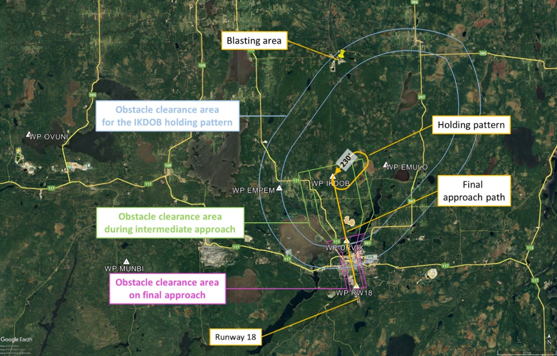
When the RNAV (GNSS) RWY 18 approach to CYVO (Appendix B) was designed, the holding pattern at IKDOB was oriented 48° from the final approach path because of a blasting area north of IKDOB. Given this unusual orientation, when an aircraft exits the holding pattern, it must manoeuvre to get established on the final approach path (Figure 16).
1.9 Communications
When the occurrence aircraft was flying in the CYVO area under 12 500 feet ASL, it was in Class E controlled airspace, which was controlled by the Montréal ACC. During the occurrence, given that the ACC had no position data on the other flying aircraft, separation between the instrument flight rules (IFR) aircraft was maintained using non-radar procedures.
When the aircraft exited the holding pattern to conduct the approach, the Montréal ACC asked the flight crew to switch over to the CYVO control zone’s mandatory frequency, which covers the airspace within a 5 NM radius of the airport up to an altitude of 4000 feet ASL.NAV CANADA, Canada Flight Supplement (CFS), effective 05 October 2023 to 30 November 2023, Aerodrome/facility directory – Val-d’Or, heading COMM. When entering this mandatory frequency area, pilots must report their position on frequency 118.5 MHz. On the 1st approach, the flight crew on the occurrence flight did not make a call on this mandatory frequency. The 1st call on the mandatory frequency was made after the aircraft was cleared for the 2nd approach by the Montréal ACC. From that point on, the required calls were made.
1.10 Aerodrome information
CYVO is located approximately 3 km south of the city of Val-d’Or, at an elevation of 1105 feet ASL. It has a single runway, Runway 18/36, which is made of asphalt and measures 10 000 feet long by 150 feet wide.
1.11 Flight recorders
The occurrence aircraft was equipped with an L3Harris FA2100 flight data recorder (serial number 000001705), which contained approximately 25 hours of flight data, including the occurrence flight. These data were successfully downloaded at the TSB Engineering Laboratory in Ottawa, Ontario.
The aircraft was also equipped with a cockpit voice recorder, which had a recording capacity of 120 minutes. However, the recording from the occurrence flight could not be downloaded because it had been overwritten by recordings from subsequent flights.
The data recorded by the FMS were downloaded, providing information on flight crew actions, methods used, and the flight plan data. However, for an undetermined reason, data related to TAWS alerts were not recorded.
1.12 Wreckage and impact information
Not applicable.
1.13 Medical and pathological information
There was no indication that the flight crew’s performance was negatively affected by medical or physiological factors, including fatigue.
1.14 Fire
There was no indication of fire either before or after the occurrence.
1.15 Survival aspects
Not applicable.
1.16 Tests and research
Three crews of seasoned pilots conducted tests in a flight simulator. In each case, the conditions experienced during the occurrence flight were reproduced up to the beginning of the left turn toward URVIX 44 seconds after exiting the holding pattern. The pilots had to attempt to rejoin the approach; however, none were successful in accomplishing this while meeting Air Creebec’s 1000-foot AGL stabilized approach criteria.
1.16.1 TSB laboratory reports
The TSB completed the following laboratory report in support of this investigation:
- LP020/2024 – Flight Data Analysis
1.17 Organizational and management information
Air Creebec is a regional airline that has main operating bases at CYVO and CYUL airports in Quebec, and at Timmins (Victor M. Power) Airport (CYTS) in Ontario. Air Creebec has scheduled flights serving 17 destinations in Quebec and Ontario, as well as chartered flights.
At the time of the occurrence, the company operated 17 aircraft under Subpart 705 (Airline Operations) of the Canadian Aviation Regulations. Its fleet comprised 1 Hawker Siddeley HS-748, 14 DHC-8-100s, and 2 DHC-8-300s.
Air Creebec has a safety management system that follows Transport Canada guidelines and that has been approved under the requirements of subparts 107 and 705 of the Canadian Aviation Regulations. This safety management system encompasses all of the company’s activities pertaining to aircraft operations and related equipment, as well as service-related activities.
1.17.1 Standard operating procedures
Air Creebec’s standard operating procedures (SOPs) for DHC-8s contain instructions and information to ensure that personnel perform their duties in a consistent manner by following common procedures. The following sections give an overview of several policies and procedures pertinent to the investigation that can be found in Air Creebec’s SOPs.
1.17.1.1 How the flight management system works
The manufacturer’s FMS user manual explains how all of the system components work, and Air Creebec has incorporated FMS operating procedures into its SOPs.
1.17.1.1.1 Instrument approach procedures
In the Required Navigation Performance Approach section, the SOPs include the following additional procedures that must be carried out before the approach:
In addition to normal procedures prior to commencing the approach (before the Initial Approach Fix - IAF), pilots must verify the accuracy of the loaded procedure [in the FMS] by comparison with the appropriate approach charts. This check must include:
a) The waypoint sequence
b) Reasonableness of the tracks and distances of the approach legs, the accuracy of the inbound course and mileage of the final approach segment […]
c) The vertical path angle.Air Creebec Inc., Standard Operating Procedures Manual, Boeing/De Havilland DHC-8, Series 100/300, Amendment No. 9a (15 May 2018), Section 1: Normal Procedures, Required Navigation Performance Approach (RNP, APCH, LNAV, LNAV/VNAV, LPV), p. 1-22.
1.17.1.2 Stabilized approach criteria
Air Creebec has incorporated in the Normal Procedures section of its SOPs stabilized approach criteria that must be met. These criteria state:
All approaches must be stabilized by 1000 feet above airport elevation in IMC [instrument meteorological conditions] and 500 feet above airport elevation in VMC [visual meteorological conditions]. An approach is stabilized when all of the following criteria are met:
- The aircraft is on the correct flight path
- Only small changes in heading/pitch are necessary to maintain the correct flight path
- The airspeed is 120 KIAS (+10 to −5 KIAS)
- The aircraft is in the correct landing configuration (Gear down, Flaps 15)
- Sink rate is no greater than 1000 feet/minute; if an approach requires a sink rate greater than 1000 feet/minute a special briefing should be conducted (e.g. icing conditions)
- Power setting is appropriate for the aircraft configuration (between 20% to 30% torque at 1050 RPM)
- All briefings and checklists have been conducted
- Unique approach conditions or abnormal conditions requiring a deviation from the above elements of a stabilized approach require a special briefing.
An approach that becomes unstabilized below 1000 feet above airport elevation in IMC or 500 feet above airport elevation in VMC requires an immediate go-around.
Note: If TAWS equipped, after the 1000 feet call from TAWS, PNF will acknowledge with the call: "Check, leaving 1,000 feet”
Flight crews will not attempt to salvage a landing from an approach that is not stabilized. [emphasis in original] Any go around or missed approaches resulting from an unstable approach will be reported by using the SMS [safety management system] reporting system or by use of the Captain Trip Report.Ibid., Section 1: Normal Procedures, Approach/Landing Checklist and Procedures, p. 1-23 and 1-24.
The occurrence aircraft was equipped with a TAWS that generated an automatic callout at 1000 feet AGL. On the first approach during the occurrence flight, the flight crew did not make calls when they were descending through 1000 feet AGL.
1.17.1.3 Ground proximity warning system and terrain awareness and warning system
The SOPs provide pilots with the following instructions regarding GPWS and TAWS alerts:
The pilots must take evasive action when the GPWS/TAWS activates in flight when at lower altitudes in hilly or mountainous terrain in IFR conditions or on approach in IFR conditions. The go-around or missed approach procedure will be initiated.Ibid., Section 2: Emergency Procedures, GPWS/TAWS Alerts, p. 2-3.
1.17.2 Training on programming the flight management system
Initial and recurrent training in the simulator includes programming the FMS in all phases of flight. However, given the training scenarios used, it is possible that some pilots will not encounter the specific approach conditions faced by the occurrence flight, namely:
- a holding pattern on a course that diverges from the final approach path;
- an approach with a holding pattern at the initial approach waypoint, which is also the missed approach waypoint;
- reprogramming the FMS to recover an approach which does not perform as expected; and
- synchronization of the heading in the heading entry field in the CMD HDG function when the approach is activated while the aircraft is on a heading that is divergent from the final approach path.
1.17.3 Regulatory oversight
In January 2021 and September 2022, Transport Canada Civil Aviation performed process inspections to check if certain Air Creebec processes complied with regulatory requirements and were working. The 1st inspection did not result in any findings, and the 2nd inspection led to 2 findings that were not related to the issues involved in the occurrence flight. In response to these findings, the company submitted corrective action plans that were accepted by Transport Canada Civil Aviation.
1.18 Additional information
1.18.1 Decision making and situational awareness
Decision making in general is a cognitive process that involves identifying and choosing a course of action from several alternatives. Decision making for pilots occurs in a dynamic environment and consists of 4 steps: gathering information, processing information, making a decision, and acting on that decision. To do this successfully, pilots need to understand the relevant elements of the environment, grasp their importance, and be able to project their future state.M. R. Endsley, “Design and evaluation for situation awareness enhancement” in Proceedings of the Human Factors Society: 32nd Annual Meeting (Santa Monica [California, United States]: 1988), pp. 97 to 101.
Situational awareness is integral to pilot decision making. In a dynamic environment, situational awareness requires pilots to continuously extract information, integrate this information with previous knowledge to form a coherent mental picture, and from there, anticipate future events.SKYbrary, “Situational Awareness”, at https://www.skybrary.aero/index.php/Situational_Awareness (last accessed 19 November 2024). Shared situational awareness between flight crew members depends on the level of congruence between each pilot’s respective awareness of the situation. In that context, communication of available information between pilots is critical so that they have the same understanding of the situation.M. R. Endsley, “Toward a Theory of Situation Awareness in Dynamic Systems”, Human Factors, Volume 37, Number 1 (March 1995), pp. 32 to 64.,E. Salas, C. Prince, D. P. Baker, and L. Shrestha, “Situation Awareness in Team Performance: Implications for Measurement and Training”, Human Factors, Volume 37, Number 1 (March 1995), pp. 123 to 136. Flight crew members who have a shared situational awareness can anticipate and coordinate their actions to perform in a cohesive and efficient manner.
1.18.2 Information processing and workload
Pilots work in a complex environment that requires monitoring multiple sources and types of information. When pilots receive information that they are expecting, they tend to react quickly, without making mistakes. However, when they receive information that is contrary to their expectations, they are slower to react and their actions may not be appropriate.M. R. Endsley, “Situation awareness in aviation systems” in J. A. Wise, V. D. Hopkin, D. J. Garland (eds.), Handbook of Aviation Human Factors, 2nd Edition (CRC Press, 2010) pp. 12-1 to 12-22.
People have a limited attention span and information-processing capacity. Therefore, they may fall into the trap of attentional narrowing or channelling. They focus on certain cues in the environment that they attempt to process, while diverting their attention, intentionally or accidentally, from other cues or tasks. For example, pilots experiencing a heavy workload may concentrate on certain indicators, to the detriment of others.Ibid. Workload depends on the number of tasks to be completed within a certain period of time. If the number of tasks to be completed increases or the time available decreases, the workload increases, which can lead to certain tasks being omitted or delayed.
2.0 Analysis
The flight crew members held the appropriate licences and ratings for the occurrence flight. There was no indication that their performance was degraded by medical or physiological factors, including fatigue. The occurrence aircraft was maintained in accordance with existing regulations, no deficiencies or failures were reported, and there was no indication that a component or system malfunction played a role in this occurrence.
The aircraft was being guided by the flight management system (FMS) when it exited the holding pattern at initial approach waypoint IKDOB. At that point, the aircraft was above the approach slope and maintained a track that was divergent both laterally and vertically from the final approach trajectory. The flight crew attempted to recover the approach, but when the aircraft was near the ground, the terrain awareness and warning system (TAWS) generated alerts. The analysis will therefore focus on programming the FMS and the issues related to recovering an approach in high-workload conditions.
2.1 Holding pattern at initial approach waypoint IKDOB
2.1.1 Holding pattern design
Holding patterns that are part of an approach procedure generally have a course that is aligned with the approach path to minimize the manoeuvres needed to remain on that approach path. However, when the area navigation approach to Runway 18 using the global navigation satellite system (RNAV [GNSS] RWY 18) was designed at Val-d’Or Airport (CYVO), the holding pattern at IKDOB was oriented 48° from the final approach path because there was a blasting area north of IKDOB. Because of this orientation, when an aircraft exits the holding pattern, it must manoeuvre to join the final approach path (Figure 16, Section 1.8.1 Design of the area navigation approach to Runway 18 using the global navigation satellite system ). This manoeuvre is normally managed by the FMS and performed by the autopilot. However, if an unexpected situation arises and the turn is not carried out by the autopilot, as was the case in this occurrence, the flight crew must react quickly to redirect the aircraft toward the final approach path so that the approach path can be intercepted.
Any unexpected situation generates additional tasks because the flight crew must determine what happened and correct the anomaly. This situation increases the workload at a time when it is already high because of the number of tasks to be completed during an approach (begin the descent, reduce speed, and modify the aircraft configuration before reaching the stabilized approach gate). When faced with a high workload, pilots might concentrate on information and tasks that they deem the most critical, to the detriment of other elements. Consequently, there is a risk that their overall situational awareness of the approach will be reduced.
Finding as to risk
If holding patterns are not aligned with the final approach path, the manoeuvre to conduct the approach is more complex, and should an unexpected situation arise, the increase in workload may reduce the overall situational awareness of the approach and thus create a risk that critical tasks will not be performed.
2.1.2 Adding a holding pattern to the flight plan in the flight management system
While inbound for CYVO, the flight crew had programmed the RNAV (GNSS) RWY 18 approach in the FMS flight plan. During the descent from flight level 200, the Montréal Area Control Centre (ACC) told the flight crew that a priority medical evacuation (MEDEVAC) flight was going to land at CYVO before them, and instructed them to proceed directly to the initial approach waypoint IKDOB and conduct the published holding pattern. The pilot not flying (PNF) set the DTO [direct to] function to the initial approach waypoint IKDOB and the FMS navigated directly to IKDOB (the 5th item on the flight plan). Two other IKDOB waypoints were on the FMS flight plan: one at the beginning of the approach (the 7th item on the flight plan), and one at the end of the missed approach (the 12th item on the flight plan).
Then, when the PNF attempted to add a holding pattern at the IKDOB waypoint before the approach (the 5th item on the flight plan), by default, the FMS suggested the preprogrammed hold at the IKDOB waypoint at the end of the missed approach (the 12th item on the flight plan) (see section 1.6.4.2 Holding pattern page). On the FMS holding pattern definition page, there was nothing in the field displaying IKDOB that indicated which of the 3 IKDOB waypoints on the flight plan was being used (Figure 8, section 1.6.4.2 Holding pattern page). Given that the PNF did not change the IKDOB waypoint provided by default, when the DTO HOLD [direct to hold] function in the bottom left of this page was activated, the FMS navigated to the IKDOB missed approach holding pattern corresponding to the final waypoint on the flight plan (12th item on the flight plan). On the FMS main navigation page (NAV 1/3), it was not possible to see that there were no further waypoints after the holding pattern (Figure 10, section 1.6.4.3 Navigation pages).
Given that the FMS flight plan did not contain any further waypoints after the holding pattern, the FMS could no longer follow the approach path after the holding pattern was exited.
Finding as to causes and contributing factors
When the holding pattern was being programmed at the IKDOB waypoint before the RNAV (GNSS) RWY 18 approach at CYVO, by default, the FMS suggested the preprogrammed holding pattern at the IKDOB waypoint that was the last waypoint of the flight plan. Therefore, when the DTO HOLD [direct to hold] function was activated, given that there were no further waypoints on the FMS flight plan after the holding pattern, the aircraft was going to maintain its last heading, unbeknownst to the pilots, rather than conduct the approach.
2.1.3 Execution of the holding pattern
When the occurrence aircraft entered the holding pattern, the MEDEVAC aircraft, which was number 1 for the approach, conducted a go-around because of the poor weather conditions. However, because the MEDEVAC aircraft was not ready to conduct a 2nd approach, the ACC directed it outbound to a point west of CYVO, where it went into a holding pattern to allow other holding aircraft to conduct their approach to CYVO.
2.1.4 Exiting the holding pattern
Twelve minutes after entering the holding pattern, the occurrence flight crew received approach clearance from the ACC, which asked if the flight crew could proceed directly to the approach from their position or if they needed to fly an additional circuit in the holding pattern. The PNF was aware that at 6000 feet above sea level, the aircraft was 1590 feet above the 3° approach slope, and that the descent would need to be faster than usual to re-intercept the approach slope. Believing that the approach was programmed in the FMS and that the autopilot would navigate to the final approach path, the PNF felt that the altitude above the approach slope was not a problem and proceeded directly to the approach without flying an additional circuit in the holding pattern.
During the 30 seconds of communications with the ACC, which ended 7 seconds before the aircraft passed IKDOB, the PNF activated the PROCEED [proceed] function in the FMS to exit the holding pattern, expecting the aircraft to follow the approach path. This activation generated messages on both FMS systems, which required acknowledgment by each pilot, at a time when the flight crew was about to coordinate the beginning of the approach and the workload was high. Given that the aircraft had just passed the final waypoint on the FMS flight plan when it exited the holding pattern, the FMS maintained the aircraft on its current track, which diverged from the final approach path by 48°. The 2 horizontal situation indicators showed the course maintained by the FMS, which was straight ahead, with no lateral deviation showing on the course deviation indicator. The aircraft did not have a navigation screen showing the aircraft’s position on a map, which would be another tool available to help the flight crew build their situational awareness of the aircraft’s position.
Finding as to causes and contributing factors
Given that there were no further waypoints on the flight plan when the aircraft exited the holding pattern, the FMS maintained the aircraft on its current course, which diverged from the final approach path by 48°, complicating the manoeuvre needed to re-establish the aircraft on the approach path.
2.2 Recovering the approach
The aircraft was on a divergent track above the optimal approach slope, which required an immediate left turn and a faster-than-normal descent, while the aircraft’s speed had to be reduced to extend the wheels and flaps. Without FMS guidance to begin the approach, the flight crew had to immediately complete several tasks at the same time. A high workload is known to cause attention narrowing or channelling, which can lead to the omission or delay of certain tasks.
The PNF immediately concentrated on re-establishing the approach navigation guidance in the FMS, which reduced the cognitive resources available to them to monitor the actions of the pilot flying (PF), who was less experienced, and to reassess the decision to conduct the approach from 6000 feet above sea level. Initially, the PNF attempted to use the instrument landing system, but given that the very high frequency omnidirectional range (YVO) distance measuring equipment at Val-d’Or was not working that day, the PNF reprogrammed the RNAV (GNSS) RWY 18 approach in the FMS.
When the approach was activated (ACT APPR), both horizontal situation indicators aligned themselves with the final approach path (182°). Given that the aircraft was flying to the right of the approach path and above the approach slope, their course deviation indicators showed a full deviation to the left, and their slope indicators were fully down.
In addition, the heading entry field of the CMD HDG [command heading] function in the FMS synchronized itself with the aircraft’s heading and maintained the aircraft’s current course while waiting for confirmation of the heading entered using CMD HDG.
2.2.1 Beginning of the descent
The PNF realized that the descent had not begun and selected the minimum sector altitude of 3900 feet in the altitude preselect controller. ALT SEL [altitude preselect] mode needed to be selected by the PF for the autopilot to level the aircraft off at this altitude, which was not done. The PNF, believing that the minimum obstacle clearance altitude was correctly programmed, went back to programming the FMS so that the aircraft would turn left to intercept the final approach path.
Twenty-four seconds after exiting the holding pattern, the PF began the descent at a fixed descent rate with the autopilot VS [vertical speed] mode, and the airspeed gradually increased from 161 to 204 knots indicated airspeed (KIAS), at which point the power was reduced to the minimum.
In the meantime, the PNF once again attempted to establish a track to intercept the final approach course in the FMS.
2.2.2 Intercept function in the flight management system
The FMSs installed in Air Creebec’s DHC‑8 fleet presents a specific issue in that the heading entry field in the CMD HDG function in the FMS is not continuously synchronized with the selected heading, which is displayed on the HSI.
The aircraft’s heading is automatically proposed and highlighted in the entry field of the CMD HDG function in the FMS when the approach is activated. Therefore, as was the case for the occurrence aircraft, if the aircraft’s heading diverges from the final approach path when the approach is activated, the proposed heading will not make it possible to intercept the final approach path, and NO INTCPT [no intercept] will replace the INTERCEPT function (Figure 17).
In such a situation, the pilot must calculate and manually enter a heading that will enable interception of the final approach path so that the INTERCEPT function will be displayed. There is a high risk of error in calculating the new intercept heading and in entering the heading in the FMS because these tasks increase the workload at a critical point in a flight when the workload is already heavy.
2.2.3 Left turn to final approach waypoint URVIX
Pilots must process and incorporate multiple sources of information in a dynamic and complex environment. When they are faced with information that is contrary to their expectations, their reaction may be slower and at times inappropriate. In this occurrence, the PNF, who was faced with a heavy workload and wanted to begin a left turn toward the final approach path, accepted the heading of 231° proposed by the CMD HDG function in the FMS, which was the aircraft’s heading at the time. Given that the FMS was still maintaining the aircraft’s heading, the autopilot HDG [heading] mode (without the FMS) was used to turn left.
During these attempts to establish an intercept course using the FMS, the aircraft remained on a divergent heading for 44 seconds. This delay in beginning the turn and descent, combined with the aircraft’s acceleration to 204 KIAS at 1 minute 31 seconds from final approach waypoint URVIX, made it even more difficult to rejoin the approach.
Smooth coordination of the actions of the 2 flight crew members required effective communication to maintain a shared situational awareness. To that end, the pilots needed to communicate the information available and ensure that they had a shared understanding of the situation, despite the high workload. An analysis of the flight crew’s actions suggests that they attempted to recover the approach in a sequential manner, which may indicate a less effective coordination of task sharing. It is possible that, given the PF’s low level of experience, the PF did not fully understand the plan and expectations of the PNF (who was the captain) and was waiting for instructions from the PNF to begin the descent and left turn without FMS guidance. However, without cockpit voice recorder data, the investigation was unable to assess task coordination and communications between the 2 pilots.
When the aircraft passed final approach waypoint URVIX, it was 0.24 nautical miles to the right of the final approach path, 500 feet above the approach slope (Appendix C), and flying at an airspeed of 180 KIAS in a clean configuration (flaps and landing gear retracted). The aircraft had to maintain its 1300 fpm descent rate to rejoin the approach slope, and reduce its speed below 158 KIAS to extend the landing gear, then below 148 KIAS to extend the flaps. At that point, it was no longer possible to slow the aircraft to the 120 KIAS target speed and meet Air Creebec’s other stabilized approach criteria at 1000 feet above ground level (AGL), which the aircraft would reach in 42 seconds.
Finding as to causes and contributing factors
When the approach was being reprogrammed in the FMS, maintaining a divergent heading for 44 seconds, combined with a late descent, resulted in the aircraft arriving at the final approach waypoint at 180 KIAS in a clean configuration. At that point, it was no longer possible to slow down the aircraft to the 120 KIAS target speed and meet the company’s stabilized approach criteria at 1000 feet AGL.
When the aircraft was passing final approach waypoint URVIX, the flight crew selected the autopilot NAV [navigation] mode to transfer the aircraft’s navigation to the FMS in the hopes of intercepting the final approach path. The aircraft began a right turn, which is what was expected. However, instead of intercepting the final approach path of 182°, the aircraft continued turning right onto the heading of 231° entered using the CMD HDG [command heading] function in the FMS. With all the information displayed on navigation page NAV 1/4, the flight crew did not notice that the FMS was still in HDG SEL [heading selected] mode, with the CMD HDG set to 231°, or that the INTERCEPT function was replaced by NO INTCPT in grey (Figure 17, Section 2.2.2 The intercept function in the flight management system).
In general, rejoining the lateral track is a priority during an instrument approach so that the aircraft remains in the obstacle clearance area, given that the flight crew cannot see the ground. Therefore, when the aircraft’s heading passed the desired track (182°) while it was turning right, and still under instrument meteorological conditions, the PNF took action in the FMS to have the aircraft turn left and head directly toward the runway. This additional workload caused the PNF to lose the bigger picture of the approach and the aircraft left the obstacle clearance area on final approach while it was still in a high-speed descent, increasing the risk of collision with obstacles or terrain.
Finding as to causes and contributing factors
After the aircraft passed the final approach waypoint, it continued to turn right on a divergent vertical and lateral track and left the obstacle clearance area, risking a collision with obstacles or terrain.
2.2.4 Coordination of the go-around
While the PNF was busy establishing a path toward the runway, engine power increased from idle (0%) to 43% while the airspeed was 171 KIAS, or 13 knots above the maximum speed for lowering the landing gear and 23 knots above the maximum speed for the 1st flap selection. The increase in power suggests an intent to reduce or cease the descent. However, the aircraft maintained a fixed descent rate of approximately 1300 fpm, and the airspeed gradually increased from 171 to 187 KIAS.
When the aircraft began to turn left toward the runway, the PNF, who had made the decision to conduct a go-around, contacted the ACC for clearance to perform a go-around because of a navigation problem. At that point, the PNF was not sure of the exact position of the MEDEVAC aircraft that was holding west of CYVO, given that the occurrence aircraft did not have a navigation screen that could have shown its position and the position of other aircraft in the vicinity. Faced with this uncertainty, the PNF wanted to ensure that there was no conflict or risk of collision with the MEDEVAC aircraft. The ACC, which did not have a radar showing airborne aircraft, was unable to see that the occurrence aircraft was west of the final approach path, and therefore did not grasp the urgency of the situation. With a 2nd aircraft unable to land at CYVO even though weather conditions were reported to be above the published minima, and with other aircraft waiting to conduct their approach to CYVO, the ACC asked the occurrence flight crew to state their intentions. The communications lasted 32 seconds.
Nine seconds after the PNF began communicating with the ACC, the aircraft flew below the stabilized approach gate of 1000 feet AGL at 187 KIAS in a clean configuration, still at a descent rate of approximately 1300 fpm.
To meet the stabilized approach criteria, the aircraft’s descent rate must not exceed 1000 fpm, the target speed must be 120 KIAS (+10 to -5 KIAS), and the aircraft must be on the approach vertical and lateral trajectory in a landing configuration (landing gear extended and flaps at 15°).
Two seconds after passing the stabilized approach gate, power was partially reduced to 20%. This action indicates that the PF was still focused on the descent and speed reduction, which limited the PF’s ability to understand the communications between the PNF and the ACC about the PNF’s intention to conduct a go-around.
The flight crew’s heavy workload decreased their ability to coordinate their actions, and led to a loss in their shared situational awareness regarding the change in the approach plan to conduct a go-around. Their heavy workload also reduced their overall awareness of the situation on approach, so they did not notice when they passed the stabilized approach gate or anticipate the risk of collision with terrain while the aircraft was continuing its descent.
Finding as to causes and contributing factors
Given the high workload and the loss of shared situational awareness regarding the change in the approach plan, the PNF asked the ACC for clearance to conduct a go-around, while the PF was continuing the descent at approximately 1300 fpm as the aircraft passed the company’s stabilized approach gate at 187 KIAS, i.e., 67 knots faster than the target speed.
Consequently, while the ACC was giving specific instructions for the go-around, TAWS alerts were being generated and the FMS automatically displayed the information page showing an imminent collision with terrain. The flight crew immediately began a go-around before communications ended (appendices C and D).
Finding as to causes and contributing factors
Approximately 25 seconds after communications began with the ACC, TAWS alerts were generated and a go-around was initiated. At its lowest point, the aircraft was 405 feet AGL, flying at an airspeed of 192 KIAS (i.e., 72 knots above the target speed), in a clean configuration, approximately 1 nautical mile to the right of the approach path, and 1 nautical mile from the runway threshold.
2.3 Cockpit voice recorder
On the occurrence flight, the flight crew did not realize how close the aircraft was to the ground or how serious the situation was; therefore, they did not turn off the cockpit voice (and audio) recorder. These data were therefore overwritten by recordings from subsequent flights.
Given that the recording of TAWS alert–related data was also lost, the investigation was unable to determine the types of alerts or the precise times that they occurred.
Communication between pilots is critical when the workload is high: they must share the information available so that they can maintain the same understanding of the situation and thus anticipate and coordinate their actions and act cohesively and effectively.
Other data available regarding aircraft and FMS inputs showed that attempts to recover the approach as the aircraft was exiting the holding pattern were carried out sequentially, which delayed the descent and the left turn to intercept the final approach path. However, without the data from the cockpit voice recorder, the investigation was unable to assess how the captain, who was the PNF, managed and coordinated the tasks to be completed given the high workload. The investigation was also unable to determine if the PF’s level of experience played a role in the occurrence. Consequently, it is possible that some safety issues, especially those related to flight crew cohesion and effectiveness when dealing with a heavy workload, may not have been identified by the investigation.
Finding as to risks
If cockpit voice recorder data are not kept after an incident or accident, it may not be possible to identify and communicate safety deficiencies and learn potential lessons.
2.4 Flight management system programming training
Initial and recurrent training in the simulator include programming the FMS in all phases of flight, but not necessarily in the specific conditions encountered during the approach on the occurrence flight.
Despite the PNF’s training and experience, and although the PF had recently completed initial training (5 months earlier), the flight crew did not recognize that the programmed holding pattern was at the final IKDOB waypoint, or the last missed approach waypoint (12th item on the flight plan) rather than at the IKDOB waypoint before the approach (5th item). Therefore, when they were exiting the holding pattern, the flight crew did not realize that the FMS had no further waypoints and was going to maintain the diverging track rather than conduct the RNAV (GNSS) RWY 18 approach as anticipated.
Then, as the flight crew flew toward final approach waypoint URVIX, given all the information displayed on navigation page NAV 1/4 (Figure 18), the flight crew did not notice that the FMS was still in HDG SEL mode and that NO INTCPT was displayed in grey. Consequently, the flight crew did not realize that the final approach path would not be intercepted once the autopilot NAV mode was selected. The flight crew members were not expecting the aircraft to turn right on the heading of 231° entered using the CMD HDG function, and deviate from the final approach path.
In this occurrence, the flight crew had to deal with the unexpected behaviour of the FMS, which required a number of actions to attempt to recover the final approach path. These actions delayed the coordination and completion of other actions that were critical to the flight, such as re-intercepting the approach slope, reducing speed, and configuring the aircraft for landing. A thorough understanding of the indications on the FMS pages, which are at times subtle, is important to cut down on the time needed to interpret the displayed indications, especially in a situation where there is a heavy workload.
Finding as to causes and contributing factors
Initial and recurrent training on the FMS did not enable the flight crew to recognize the particular subtleties of the system programming, causing a discrepancy between the flight crew’s expectations and the aircraft’s behaviour, and causing difficulties with in-flight programming, all leading to a delay in completing critical flight actions.
3.0 Findings
3.1 Findings as to causes and contributing factors
These are the factors that were found to have caused or contributed to the occurrence.
- When the holding pattern was being programmed at the IKDOB waypoint before the area navigation approach to Runway 18 at Val-d’Or Airport using the global navigation satellite system, by default, the flight management system suggested the preprogrammed holding pattern at the IKDOB waypoint that was the last waypoint of the flight plan. Therefore, when the DTO HOLD [direct to hold] function was activated, given that there were no further waypoints on the flight management system flight plan after the holding pattern, the aircraft was going to maintain its last heading, unbeknownst to the pilots, rather than conduct the approach.
- Given that there were no further waypoints on the flight plan when the aircraft exited the holding pattern, the flight management system maintained the aircraft on its current course, which diverged from the final approach path by 48°, complicating the manoeuvre needed to re-establish the aircraft on the approach path.
- When the approach was being reprogrammed in the flight management system, maintaining a divergent heading for 44 seconds, combined with a late descent, resulted in the aircraft arriving at the final approach waypoint at 180 KIAS in a clean configuration (flaps and landing gear retracted). At that point, it was no longer possible to slow down the aircraft to the 120 knots indicated airspeed meet the company’s stabilized approach criteria at 1000 feet above ground level.
- After the aircraft passed the final approach waypoint, it continued to turn right on a divergent vertical and lateral track and left the obstacle clearance area, risking a collision with obstacles or terrain.
- Given the high workload and the loss of shared situational awareness regarding the change in the approach plan, the pilot not flying asked the area control centre for clearance to conduct a go-around, while the pilot flying was continuing the descent at approximately 1300 fpm as the aircraft passed the company’s stabilized approach gate at 187 knots indicated airspeed, i.e., 67 knots faster than the target speed.
- Approximately 25 seconds after communications began with the area control centre, alerts were generated by the terrain awareness and warning system and a go-around was initiated. At its lowest point, the aircraft was 405 feet above ground level, flying at an airspeed of 192 knots indicated airspeed (i.e., 72 knots above the target speed), in a clean configuration, approximately 1 nautical mile to the right of the approach path, and 1 nautical mile from the runway threshold.
- Initial and recurrent training on the flight management system did not enable the flight crew to recognize the particular subtleties of the system programming, causing a discrepancy between the flight crew’s expectations and the aircraft’s behaviour, and causing difficulties with in-flight programming, all leading to a delay in completing critical flight actions.
3.2 Findings as to risk
These are the factors in the occurrence that were found to pose a risk to the transportation system. These factors may or may not have been causal or contributing to the occurrence but could pose a risk in the future.
- If holding patterns are not aligned with the final approach path, the manoeuvre to conduct the approach is more complex, and should an unexpected situation arise, the increase in workload may reduce the overall situational awareness of the approach and thus create a risk that critical tasks will not be performed.
- If cockpit voice recorder data are not kept after an incident or accident, it may not be possible to identify and communicate safety deficiencies and learn potential lessons.
4.0 Safety action
4.1 Safety action taken
4.1.1 Air Creebec Inc.
In response to this occurrence, Air Creebec Inc. initiated the following safety actions:
- Memoranda
- A memorandum was released in November 2023 describing some difficult situations that might occur during approaches and reminding pilots to decline any clearance from the area control centre (ACC) that could place them in a difficult situation and that could considerably increase the risk of an unstable approach.
- A memorandum was released in January 2024 to make flight crews aware of how to program holding patterns at an approach waypoint when the approach in the flight management system (FMS) is already associated with a preprogrammed holding pattern.
- Changes to the standard operating procedures (SOPs)
- Section 8 of the SOPs was revised to explain more clearly how to program holding patterns in the FMS and manage the closure of standard terminal arrival routes.
- The January 2024 memorandum was incorporated into the SOPs, in the revised FMS section.
- Simulator training
- The simulator training program was modified to include difficult requests from the ACC. Also, instructors must now create scenarios that lead to an unstable approach, so that flight crews become aware of the need to question clearances from the ACC in some cases, and of the importance of conducting a go-around when they feel that an approach is going to become unstable.
- The number of flight simulator hours during initial training on the DHC-8 was increased by 24 hours per candidate in comparison to the previous initial training program.
- The 2024 line-oriented flight training program was revised to incorporate scenarios in which flight crews are placed in situations where the FMS is difficult to program.
- Observation flights
- Air Creebec Inc. has introduced ongoing crew resource management observation flights to improve crew management and understand how it applies in the company’s cockpits. These flights are very similar to a line operations safety audit.
This report concludes the Transportation Safety Board of Canada’s investigation into this occurrence. The Board authorized the release of this report on 08 October 2025. It was officially released on 28 October 2025.
Appendices
Appendix A — Graphic Area Forecast Clouds and Weather Chart
Source: NAV CANADA, with TSB annotations
Appendix B — Val d’Or airport’s RNAV (GNSS) RWY 18 approach chart
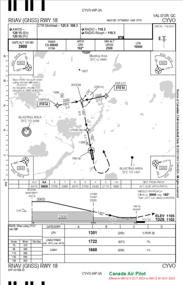
Source: NAV CANADA, Canada Air Pilot (CAP), CAP 5: Quebec (effective 05 October 2023)
Appendix C — Detailed sequence of events
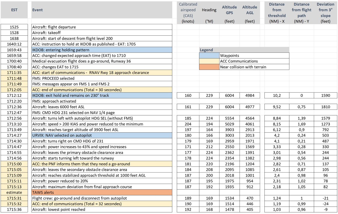
Source: TSB
Appendix D — Flight data
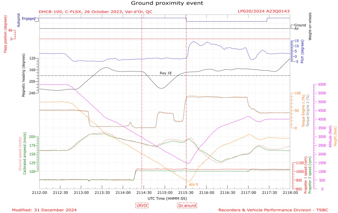
Source: TSB Engineering Laboratory
![Figure 12. MANEUVER page in HOLDING [holding pattern] mode (Source: Universal Avionics, FMS Trainer v4.1.0.600) Figure 12. MANEUVER page in HOLDING [holding pattern] mode (Source: Universal Avionics, FMS Trainer v4.1.0.600)](/sites/default/files/2025-10/A23Q0143-figure-12-BIL.jpg)
![Figure 13. Main navigation page after activating the PROCEED [proceed to] function to exit the holding pattern (Source: Universal Avionics, FMS Trainer v4.1.0.600) Figure 13. Main navigation page after activating the PROCEED [proceed to] function to exit the holding pattern (Source: Universal Avionics, FMS Trainer v4.1.0.600)](/sites/default/files/2025-10/A23Q0143-figure-13-BIL.jpg)
![Figure 14. Navigation page in HDG SEL [heading selected] mode, after activation of the approach (Source: Universal Avionics, FMS Trainer v4.1.0.600) Figure 14. Navigation page in HDG SEL [heading selected] mode, after activation of the approach (Source: Universal Avionics, FMS Trainer v4.1.0.600)](/sites/default/files/2025-10/A23Q0143-figure-14-BIL.jpg)
![Figure 16. Diagram showing the flight path as the aircraft was exiting the holding pattern at IKDOB (Source: NAV CANADA, Canada Air Pilot [CAP], CAP 6: Quebec [effective 05 October 2023], with TSB annotations) Figure 16. Diagram showing the flight path as the aircraft was exiting the holding pattern at IKDOB (Source: NAV CANADA, Canada Air Pilot [CAP], CAP 6: Quebec [effective 05 October 2023], with TSB annotations)](/sites/default/files/2025-10/A23Q0143-figure-16-BIL.jpg)
![Figure 17. Navigation page in HDG SEL [heading selected] mode, after activation of the approach (Source: Universal Avionics, FMS Trainer v4.1.0.600) Figure 17. Navigation page in HDG SEL [heading selected] mode, after activation of the approach (Source: Universal Avionics, FMS Trainer v4.1.0.600)](/sites/default/files/2025-10/A23Q0143-figure-17-BIL.jpg)
![Figure 18. Navigation page in HDG SEL [heading selected] mode, as the aircraft flew toward waypoint URVIX (Source: Universal Avionics, FMS Trainer v4.1.0.600) Figure 18. Navigation page in HDG SEL [heading selected] mode, as the aircraft flew toward waypoint URVIX (Source: Universal Avionics, FMS Trainer v4.1.0.600)](/sites/default/files/2025-10/A23Q0143-figure-18-BIL.jpg)
