In-flight icing and collision with terrain
Privately registered
Mooney M20K, C-GQMS
Calgary/Springbank Airport, Alberta, 0.6 NM S
The Transportation Safety Board of Canada (TSB) investigated this occurrence for the purpose of advancing transportation safety. It is not the function of the Board to assign fault or determine civil or criminal liability. This report is not created for use in the context of legal, disciplinary or other proceedings. See Ownership and use of content. Masculine pronouns and position titles may be used to signify all genders to comply with the Canadian Transportation Accident Investigation and Safety Board Act (S.C. 1989, c. 3).
History of the flight
At 1427Footnote 1 on 22 April 2022, the Mooney M20K (Mooney 231) aircraft (registration C-GQMS, serial number 25-0536) departed Runway 35 at Calgary/Springbank Airport (CYBW), Alberta, for a local round-robin flight on an instrument flight rules (IFR) flight plan with 2 pilots on board. The aircraft had recently been purchased, and the purpose of this flight was for the right-seat pilot to become familiar with operating the Mooney 231 and learn from the pilot-in-command, who was occupying the left seat and had experience on the aircraft type. The aircraft was later to be relocated to its new owner in Fort St. John, British Columbia, where the right-seat pilot was to provide type-specific instruction to the new owner.
After takeoff, the aircraft turned left toward the TURNY waypoint, climbing to a cruising altitude of 9000 feet above sea level (ASL). It flew over High River Aerodrome (CEN4), Alberta, and headed northeast toward the EBGAL waypoint. The aircraft then turned left and proceeded back toward the TURNY waypoint. When the aircraft was flying just northwest of Okotoks (CFX2), Alberta, at an altitude of approximately 8000 feet ASL, it turned slightly to the right to cross the initial approach waypoint (SEKEM) and return to CYBW for an instrument approach and landing on Runway 35 (Figure 1).
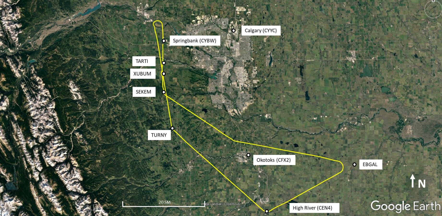
At 1509, before crossing SEKEM, the pilot-in-command contacted air traffic services (ATS) and requested a lower altitude because the aircraft was “picking up a little ice.” ATS cleared the aircraft to descend, with a restriction of not below 6200 feet ASL.
The aircraft crossed SEKEM at an altitude of 6100 feet ASL, travelling at a ground speed of 97 knots. It then crossed the step-down waypoint (XUBUM) at an altitude of 5900 feet ASL, travelling at a ground speed of 114 knots, and crossed the final approach waypoint (TARTI) at an altitude of 5800 feet ASL, approximately 500 feet above the vertical path angle and still travelling at a ground speed of 114 knots.
The aircraft continued to descend, and passed below the vertical path and ultimately below the decision altitude of 4190 feet ASL.Footnote 2 At 1518, it struck the bank of a ditch on the north side of the Trans-Canada Highway, 0.6 nautical miles (NM) south of the threshold of the runway, and slid to a halt in a pasture. The pilot-in-command was fatally injured from the impact forces, and the right-seat pilot received serious injuries. The emergency locator transmitter (ELT) activated and transmitted a signal.
Pilot information
The pilot-in-command held a valid private pilot licence, endorsed with a group 1 instrument rating and a multi-engine rating. The pilot met the recency requirements for the group 1 instrument rating.Footnote 3 He had accumulated approximately 1790 hours total time, which included approximately 540 hours in Mooney M20 series aircraft.
The right-seat pilot held a valid commercial pilot licence, endorsed with a group 1 instrument rating, a multi-engine rating, and a class 3 flight instructor rating. At the time of the occurrence, she had accumulated approximately 1100 hours total flight time. She had no previous experience on the Mooney M20 series of aircraft.
Aircraft information
The Mooney M20K is a low-wing, single-engine, 4-seat, general aviation aircraft with retractable tricycle landing gear. It is powered by a turbocharged 6-cylinder piston engine. The occurrence aircraft was manufactured in 1981.
The investigation did not identify any issues related to the aircraft’s equipment or maintenance that would have prevented it from operating normally during the occurrence flight. The aircraft had been purchased by a new owner in March 2022 and, as part of that process, had gone through extensive maintenance, including an annual inspection.
The aircraft was not equipped with a flight data recorder or a cockpit voice recorder, nor was it required to be by regulation. The aircraft was also not equipped, or certified, for flight into known or forecast icing conditions. The Canadian Aviation RegulationsFootnote 4 stipulate that where icing conditions are reported to exist or are forecast to be encountered, the aircraft must be adequately equipped to operate in icing conditions.
The aircraft was equipped with electric deicing boots on the propeller. It was also equipped with a 406 MHz ELT (Artex ELT 345), which activated. The signal was received by the Joint Rescue Co-ordination Centre (JRCC) in Trenton, Ontario.
Impact and wreckage information
The aircraft collided with the bank of a ditch on the north side of the westbound lanes of the Trans-Canada Highway. The aircraft hit the ground in right-wing-low, nose-down attitude, went through a barbed wire fence, and came to rest 68 feet north of the ditch, facing a southerly direction (Figure 2).
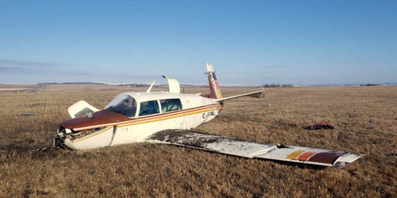
During the impact sequence, the right wing broke off the aircraft, the crankshaft propeller flange and propeller broke free, the left main landing gear was torn from the left wing, and the left elevator contacted the field, resulting in significant damage and distortion to the aft fuselage. After the aircraft came to rest, the engine continued to run at high speed because there was no longer any propeller load on the engine. Bystanders turned off the ignition to the engine and provided assistance to the aircraft occupants.
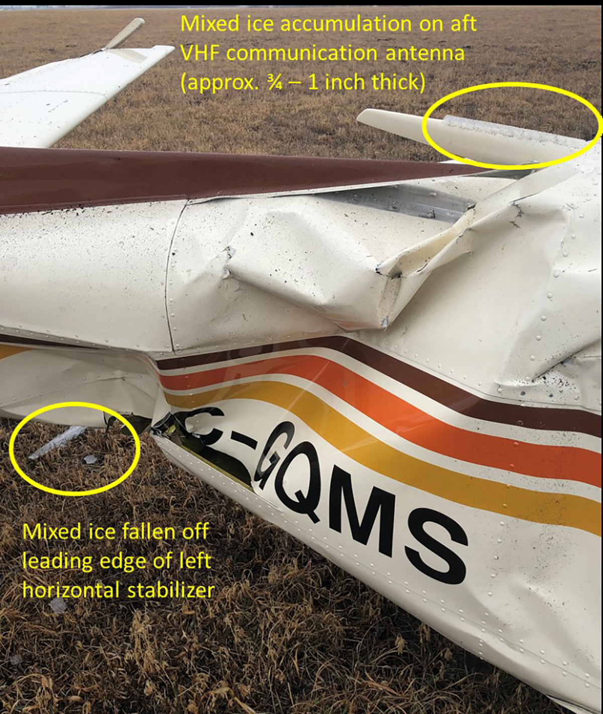
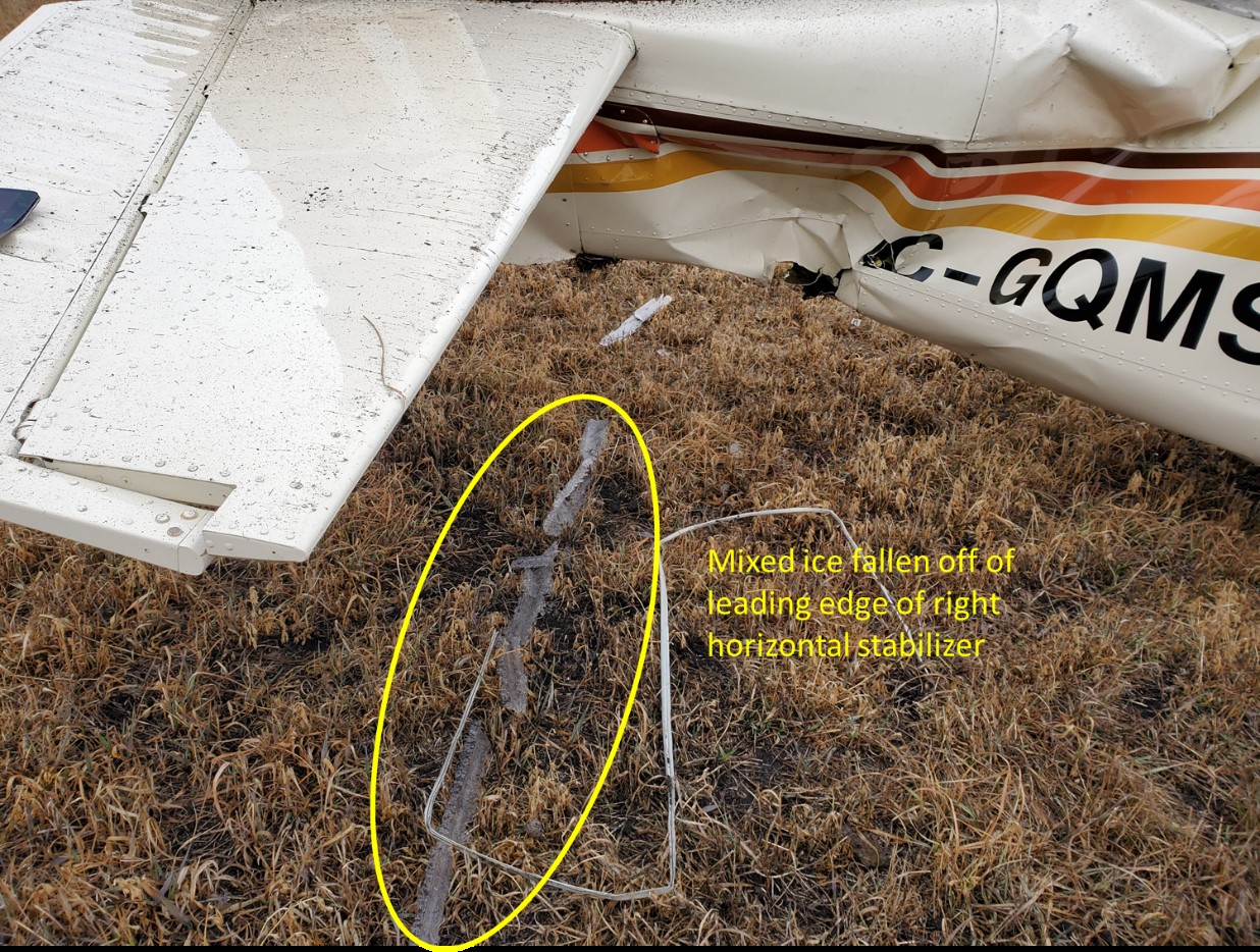
RCMP (Royal Canadian Mounted Police) officers from the Cochrane detachment responded shortly after the accident. Several photos were taken of the exterior of the aircraft and shared with the TSB. The photos revealed a build-up of mixed ice on the aft VHF (very high frequency) communication antenna, the leading edges of the horizontal stabilizer, and the leading edge of the left wing (figures 3 and 4). The investigation estimated the build-up of the mixed ice on the VHF communication antenna to be between ¾ and 1 inch thick.
The aircraft’s digital tachometer was sent to the TSB Engineering Laboratory in Ottawa, Ontario, for analysis. The data recovered from the unit indicated that the engine was operating normally for the duration of the flight.
Weather
At 1316 an amended aerodrome forecast (TAF) was issued for CYBW, forecasting the following:
- Visibility more than 6 statute miles (SM) in light snow
- Scattered clouds at 600 feet above ground level (AGL) and overcast ceiling at 2500 feet AGL
- Temporarily between 1300 and 1500, visibility 1 SM in light rain showers, snow, and mist
- Broken ceiling at 600 feet AGL, overcast cloud layer at 1500 feet AGL
Between 1300 and 1400, the automated weather observation system (AWOS) at CYBW issued 9 aerodrome special meteorological reports (SPECIs), reporting significant changes in the weather.
The CYBW automatic aerodrome routine meteorological report (METAR AUTO) issued at 1400 reported the following:
- Visibility 9 SM in light rain
- Overcast ceiling at 900 feet AGL
- Temperature 1.2 °C, dew point 0.0 °C
- Altimeter setting 29.90 inHg
At 1400, the CYBW automatic terminal information service (ATIS) was reporting information “Papa,” which included the weather information from the METAR issued at 1400, and reported the Runway 35 surface condition as 100% covered in 1/8 inch of slush.
At 1500, 18 minutes before the accident, the CYBW ATIS was reporting information “Quebec,” with the following conditions:
- Winds from 030° magnetic (M) at 5 knots
- Visibility 9 SM
- Overcast ceiling at 1000 feet AGL
- Temperature 1.1 °C, dew point −0 °C
- Altimeter 29.91 inHg
- Runway 35 surface condition reported as 100% wet
At 1516, the AWOS issued a SPECI, reporting the following conditions:
- Visibility 9 SM in light rain
- Overcast ceiling at 800 feet AGL
- Temperature 0.8 °C, dew point −0.1 °C
The Clouds and Weather Chart of the graphic area forecast (GFA) valid at the time of the occurrence indicated frequent altocumulus castellanus clouds in the vicinity and to the west of CYBW. These clouds continued all the way to the border with British Columbia, with a visibility of 1 to 4 SM in light snow showers, and patchy ceilings between 800 and 1500 feet AGL. A note below the legend on the Clouds and Weather Chart states: “CB TCU AND ACC IMPLY SIG TURB AND ICE” (cumulonimbus, towering cumulus, and altocumulus castellanus imply significant turbulence and icing).
The Icing, Turbulence, and Freezing Level Chart of the GFA did not depict any areas of moderate or severe icing conditions in the vicinity of CYBW; however, it did indicate the freezing level to be at 5000 feet ASL. A note below the legend on the Icing, Turbulence, and Freezing Level Chart states: “NIL-LGT RIME ICEIC ABV FZLVL UNLS NOTED” (nil to light rime icing is to be expected in cloud above the freezing level unless noted).
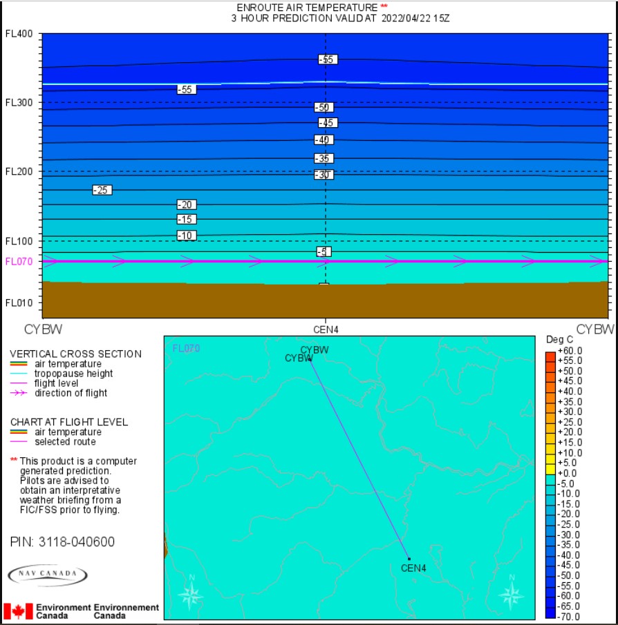
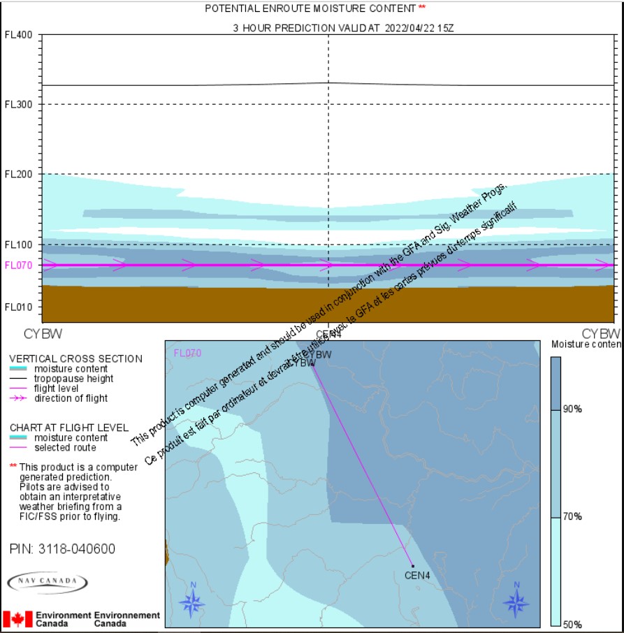
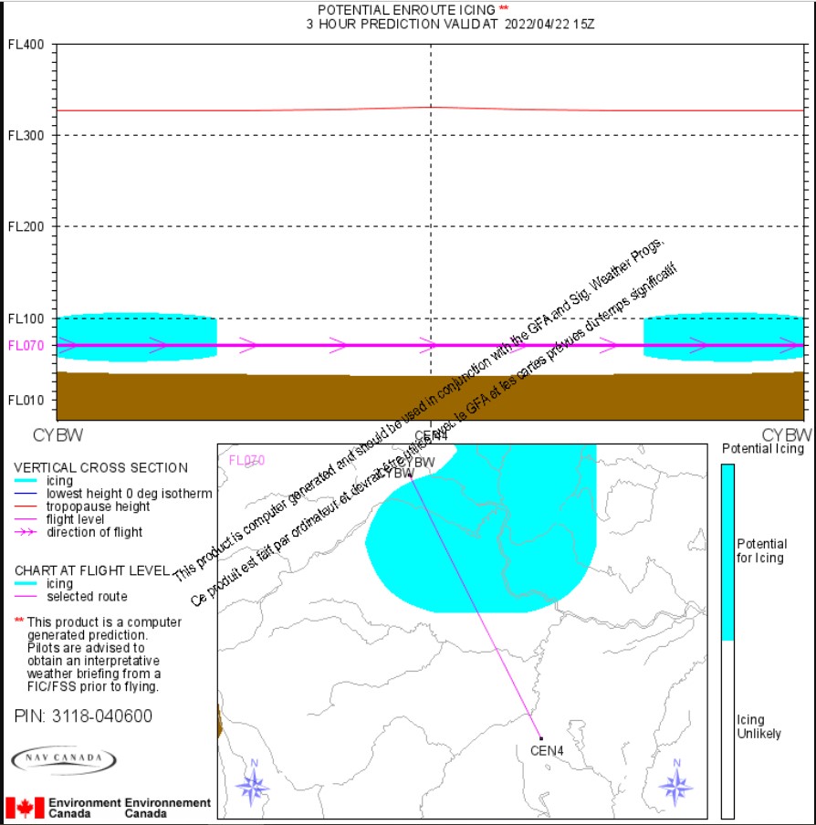
In addition to the weather information products mentioned above, pilots can consult NAV CANADA’s automated supplementary enroute weather predictions (ASEP) page from the Aviation Weather Web Site.Footnote 5 Appendix A provides samples of the graphic depictions of the conditions between 0900 and 1200 on the day of the occurrence. These graphics depict the potential for an aircraft to experience in-flight icing in the vicinity of the planned flight route and at the planned altitude.
The investigation was unable to determine with certainty what weather information the pilots consulted before the occurrence flight; however, the pilots had not contacted a NAV CANADA flight information centre for a weather briefing before departure. The Canadian Aviation RegulationsFootnote 6 require that the pilot-in-command be familiar with the available weather information appropriate for the intended flight.
In-flight icing
Ice can form on aircraft in flight, mainly as a result of 3 processes: super cooled water droplets, freezing of liquid water, or the transition of vapour directly to ice. Depending on the process involved and the conditions, these accretions are normally classified into 4 categories: clear ice, rime ice, mixed ice, and hoarfrost. All of these types of accretions degrade performance, although to varying degrees, and all aircraft are affected negatively when accumulating ice in flight.
![Graph showing how ice affects the coefficient of lift for an airfoil (Source: Federal Aviation Administration, Advisory Circular AC 91-74B: Pilot Guide: Flight in Icing Conditions [August 2015], Figure 3-5.)](/sites/default/files/eng/rapports-reports/aviation/2022/a22w0027/images/a22w0027-figure-05.jpg)
Structural aircraft icing occurs when the various parts of an aircraft (wings, stabilizers, antenna, etc.) accumulate ice during flight. The effects of structural icing on aircraft performance have been well documented. In August 2015, the U.S. Federal Aviation Administration published Advisory Circular (AC) 91-74B: Pilot Guide: Flight in Icing Conditions, which provides “essential information concerning safe flight in icing conditions, what conditions a pilot should avoid, and how to avoid or exit those conditions if encountered.”Footnote 7
As described in AC 91-74B, the accumulation of even a small amount of ice on an airfoilFootnote 8 in flight significantly reduces the maximum amount of lift available at any given airspeed or angle of attack, and significantly reduces the angle of attack at which a stall occurs (Figure 5). It is not unusual for the maximum coefficient of lift to be reduced by 30%.Footnote 9
![Graph showing how ice affects the drag coefficient of an airfoil (Source: Federal Aviation Administration, Advisory Circular AC 91-74B: Pilot Guide: Flight in Icing Conditions [August 2015], Figure 3-6.)](/sites/default/files/eng/rapports-reports/aviation/2022/a22w0027/images/a22w0027-figure-06.jpg)
The accumulation of ice also has a detrimental effect on the drag of an airfoil (Figure 6). This means that as ice accumulates on the surface of the airfoil, the drag increases significantly and quickly as the angle of attack increases. It is not unusual for drag to increase by 100%.Footnote 10
In addition, AC 91-74B notes the following:
An aircraft with a completely unprotected wing is unlikely to be certificated for flight in icing conditions, but may inadvertently encounter icing conditions. […] The ice causes an increase in drag, which the pilot detects as a loss in airspeed or an increase in the power required to maintain the same airspeed. (The drag increase is also due to ice on other parts of the aircraft). The longer the encounter, the greater the drag increase; even with increased power, it may not be possible to maintain airspeed. If the aircraft has relatively limited power (as is the case with many aircraft with no ice protection), it may soon approach stall speed and a dangerous situation.Footnote 11
TSB laboratory reports
The TSB completed the following laboratory reports in support of this investigation:
- LP044/2022 – Radar Analysis
- LP036/2022 – NVM Recovery – Various Devices
Safety messages
Pilots must be diligent when checking the weather before a flight by consulting all available weather resources, including NAV CANADA flight information centres, and reviewing all available weather products, including pilot reports and special weather reports, for the area of the planned flight.
Weather conditions that are conducive to icing are difficult to predict. If icing is encountered when flying aircraft that are not certified for icing conditions, it is imperative that pilots exit the icing conditions immediately. Additionally, pilots should treat this situation as an emergency and declare it as such in order to obtain all available assistance.
This report concludes the Transportation Safety Board of Canada’s investigation into this occurrence. The Board authorized the release of this report on . It was officially released on .
Appendix A - Automated supplementary en route weather predictions (ASEP) for the occurrence flight