Collision with obstacle on approach
Sandy Lake Seaplane Service Ltd.
Cessna U206G, C-GBGJ
Sandy Lake First Nation, Ontario
The Transportation Safety Board of Canada (TSB) investigated this occurrence for the purpose of advancing transportation safety. It is not the function of the Board to assign fault or determine civil or criminal liability. This report is not created for use in the context of legal, disciplinary or other proceedings. See Ownership and use of content. Masculine pronouns and position titles may be used to signify all genders to comply with the Canadian Transportation Accident Investigation and Safety Board Act (S.C. 1989, c. 3).
History of the flight
At 1545Footnote 1 on 26 May 2022, the Sandy Lake Seaplane Service Ltd. float-equipped Cessna U206G aircraft (registration C-GBGJ, serial number U20605249) departed Sandy Lake Water Aerodrome (CKE5), Ontario, for a personal flightFootnote 2 to an unnamed lake located 41 nautical miles (NM) north-northeast of CKE5. The purpose of the flight was to bring boat fuel and groceries to the pilot’s cabin located at the unnamed lake. The weather was suitable for the visual flight rules flight, with nearby weather stations reporting winds generally at 10 knots or less, visibility 9 statute miles, and scattered clouds above 5500 feet above ground level (AGL).
At approximately 1830, the aircraft departed the unnamed lake for the return flight to CKE5. As the aircraft approached CKE5, the pilot transmitted position reports on the aerodrome traffic frequency. At 1853, when the aircraft was flying over the community of Sandy Lake First Nation on final approach for a south-southwest direction landing at CKE5, it struck a 132-foot-tall communications tower located at the Nishnawbe Aski Police Service’s Sandy Lake First Nation detachment. The aircraft subsequently collided with terrain and a post-impact fire ensued. The pilot was fatally injured.
The emergency locator transmitter (ELT) activated as a result of the impact and the Joint Rescue Coordination Centre in Trenton, Ontario, received the signal at 1854. The Nishnawbe Aski Police Service and the Sandy Lake First Nation Fire Department responded to the scene.
Wreckage and impact information
During approach for landing on the lake, the occurrence aircraft struck the communications tower and then descended through a set of hydro lines before colliding with trees in a wooded area. The wreckage came to rest approximately 280 feet from the base of the communications tower. Approximately 80% of the airframe was consumed by the post-impact fire.
Damage to the propeller was indicative of contact with a metal object, suggesting that the propeller was rotating and the engine was producing power when the communications tower was struck. Antenna pieces found near the communications tower exhibited damage consistent with shear. This indicates that the aircraft hit the tower at approximately 126 feet AGL and laterally centered on the aircraft; in line with the propeller.
A portion of the right wing—near the wing tip and including the aileron—was found hanging from the hydro line. Damage to the wing tip was indicative of shear from the collision with the hydro line.
An inspection of all flight control cables did not reveal any pre-impact anomalies. Inspections of both control wheels and columns were inconclusive due to fire damage. Examination of the flap actuator jackscrew extension suggests a flap setting of approximately 24° at the time of impact; however, inspection of the flap system for continuity was also inconclusive due to fire damage.
The 406 MHz ELT emitted a signal before it was destroyed in the fire.
Pilot information
The pilot held a private pilot licence – aeroplane and his Category 3 medical certificate was valid. His licence was endorsed for single-engine landplanes and seaplanes, with a restriction of daylight flying only. The pilot had previously held a commercial pilot licence – aeroplane and had accumulated approximately 20 000 hours of flying time, a substantial portion of which was flying in the Sandy Lake area.
Aircraft information
The occurrence Cessna U206G was a float-equipped, single-engine, high-wing aircraft manufactured in 1979 by the Cessna Aircraft Company. The aircraft was commercially registered to Sandy Lake Seaplane Service Ltd. and was maintained on the operator's approved maintenance schedule. A 100-hour inspection was completed on the aircraft on 11 March 2022. The aircraft had accumulated a total airframe time of 10 659 hours at the time of the occurrence.
A review of the aircraft journey log and technical records did not reveal any outstanding defects that may have contributed to the occurrence. The aircraft had approximately 190 pounds of fuel and a total gross weight of 2906 pounds at the time of the occurrence, which is below the maximum certified take-off weight of 3500 pounds. It was determined that the aircraft was operated within the allowable weight and centre-of-gravity limitations for the occurrence flight.
Aerodrome information
CKE5 is a registered water aerodrome operated by Sandy Lake Seaplane Service Ltd. It is located ¼ NM southeast of the Sandy Lake Airport (CZSJ), Ontario.
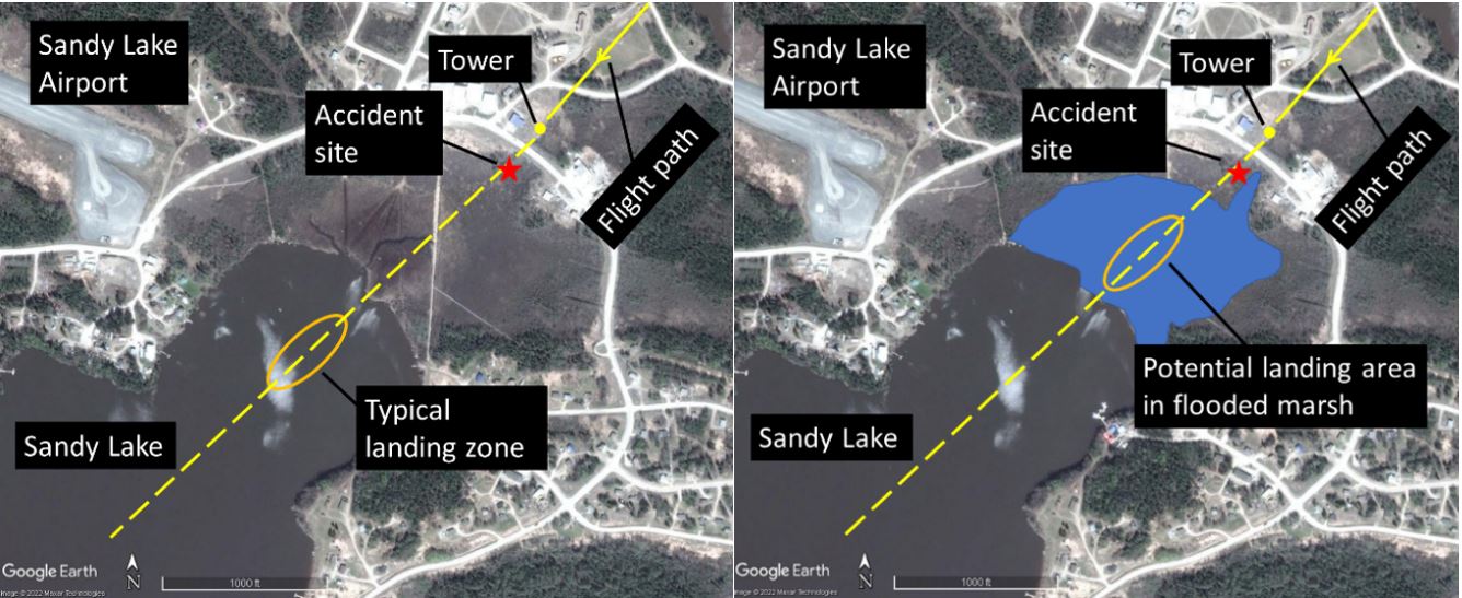
At the time of the occurrence, Sandy Lake had a higher-than-normal water level caused by a greater-than-normal snow melt and a rainy spring. As a result, what is normally a marshy area northeast of the landing area was fully submerged in water (Figure 1). The normal elevation of the lake is 901 feet above sea level (ASL).
Tower information
The communications tower was installed on 03 March 2012. It was equipped with a red beacon. The steel tower’s main structure was 120 feet tall, and a 12-foot antenna was mounted on top of the main structure, resulting in a tower height of 132 feet AGL. Given that the ground elevation at the tower site is 916 feet ASL, the height of the tower is 1048 feet ASL.
The height of the tower was below the threshold for it to be included in aeronautical publications, including area diagrams for CKE5 and CZSJ.
Normal visual landing procedure
A southwest-bound approach to the typical landing zone at CKE5 requires an aircraft to be flown at a slope angle of greater than 4° to avoid the tower. This equates to a height reduction of 70 feet per 1000 feet travelled horizontally. Should the target landing area be moved 1200 feet further northeast, into the flooded marsh area, an approach flown with a 4° slope would be 84 feet lower than normal when passing the tower.
Safety messages
It is important for pilots to remember that a change in a familiar approach environment can cause obstacles that are not normally an issue to become a factor during landing. Therefore, pilots must remain vigilant when selecting a landing area to ensure a safe distance is maintained from obstacles.
This report concludes the Transportation Safety Board of Canada’s investigation into this occurrence. The Board authorized the release of this report on . It was officially released on .