Loss of engine power and collision with terrain
Publicité AERO-GRAMME Inc.
Cessna 172M, C-FFRV
Montréal/Pierre Elliott Trudeau International Airport, Quebec, 8.45 NM E
The Transportation Safety Board of Canada (TSB) investigated this occurrence for the purpose of advancing transportation safety. It is not the function of the Board to assign fault or determine civil or criminal liability. This report is not created for use in the context of legal, disciplinary or other proceedings. See Ownership and use of content. Masculine pronouns and position titles may be used to signify all genders to comply with the Canadian Transportation Accident Investigation and Safety Board Act (S.C. 1989, c. 3).
Summary
On 02 October 2021, at approximately 1745 Eastern Daylight Time, the Cessna 172M aircraft (registration C-FFRV, serial number 17262394) operated by Publicité AERO-GRAMME Inc., took off from St-Mathieu-de-Laprairie Aerodrome (CML8), Quebec, to conduct a visual flight rules aerial advertising flight in the region of Montréal, Quebec. One pilot and 1 passenger were on board. While the aircraft was flying over the St. Lawrence River near the Concorde Bridge, a loss of engine power occurred. While the pilot was attempting to conduct an emergency landing on Pierre-Dupuy Avenue, in the borough of Ville-Marie, Montréal, the left wing grazed some treetops. The aircraft began to cartwheel and struck the ground. There was a post-impact fire. The pilot was seriously injured but managed to evacuate the aircraft. The passenger was unable to evacuate the aircraft and received fatal injuries. The aircraft was destroyed. No signal was detected from the emergency locator transmitter.
1.0 Factual information
1.1 History of the flight
During the day of 02 October 2021, the occurrence pilot began preparations for an aerial advertising (banner-towing) flight that was to be conducted in the late afternoon. At 1332,Footnote 1 in preparation for the flight, the pilot sent an email to air traffic control (ATC) to inform them of the visual flight rules (VFR) flight, estimated to last approximately 8 minutes, that he was planning to conduct at an altitude of 1200 feet above sea level (ASL) in the Montréal, Quebec, control zone. The aircraft was to take off from the St-Mathieu-de-Laprairie Aerodrome (CML8), Quebec, and fly over Place Ville-Marie in the borough of the same name in downtown Montréal. The aircraft was to enter the control zone at 1800 and leave it at 1808.
At 1427, the pilot contacted the Québec flight information centre (FIC) to obtain a weather forecast for the Montréal area. At approximately 1553, after reviewing the available weather information, the pilot informed his client that conditions were acceptable and that he was preparing for the flight.
As required by ATC, the pilot contacted the Québec FIC at around 1626 to obtain a transponder code,Footnote 2 which would allow him to conduct the flight in the control zone. At approximately 1705, after rechecking the weather forecast, he left his home and went to CML8 to prepare the aircraft, a Cessna 172M (registration C-FFRV, serial number 17262394) operated by Publicité AERO-GRAMME Inc. (AEROGRAM).
The aircraft took off from CML8 at around 1745, with the pilot and 1 passenger on board. After conducting a circuit to attach the banner, the pilot made initial contact with the tower controller at the Montréal/Pierre Elliott Trudeau International Airport (CYUL), Quebec, at around 1750. When the aircraft was flying northward over the municipality of Saint-Constant, Quebec, in level flight at an altitude of approximately 500 feet ASLFootnote 3 to remain within VFR flight conditions, the pilot informed the controller that he was going to climb to an altitude of 1200 feet ASL to conduct a banner-towing flight over downtown Montréal, but was waiting to be clear of the clouds.
At 1750:14, at the request of the Montréal tower controller, the pilot contacted the tower at the Montréal/St-Hubert Airport (CYHU), Quebec. The pilot confirmed to the CYHU tower controller that he was still planning to fly toward downtown Montréal, but was waiting to be clear of the clouds. The aircraft was still at an altitude of 500 feet ASL.
At approximately 1752, the aircraft reached the south shore of the St. Lawrence River, still at the same altitude, and around 1754, the pilot contacted the Montréal tower controller again. At that point, the aircraft was near the north shore of the river, still at the same altitude. The air traffic controller provided the pilot with the weather observation issued for CYUL and gave the pilot the following instruction, asking him to maintain VFR at all times: “Foxtrot Romeo Victor, last sequence at 21Z was saying 15 miles [visibility], light drizzle, few clouds 800 feet [above ground level], broken 1400 and overcast at 2200. Maintain VFR and advise completed.”
After the aircraft crossed the river, it turned right and headed north-northeast. The aircraft was still flying at an altitude of 500 feet ASL and was heading toward the Old Port of Montréal. At approximately 1759, shortly after flying by Place Ville-Marie, the aircraft turned to the east near the King Edward Quay to return to CML8 because it was not able to climb to a higher altitude. The aircraft then proceeded eastward, crossing over Dieppe Park on the south side of the Concorde Bridge.
Shortly thereafter, while the aircraft was flying over the river, the engine sputtered and the pilot turned on the carburetor heat control. The engine seemed to regain some power, but then sputtered and lost power again. The aircraft was no longer able to maintain its altitude. The pilot then began a left turn and released the banner in preparation for an emergency landing on the Concorde Bridge. However, after noticing concrete barriers on the bridge indicating that construction work was in progress, which prevented a safe landing, the pilot continued the turn with the intention of landing on Pierre-Dupuy Avenue (Figure 1). At the time of the emergency landing, CYUL was reporting winds from the northeast at 6 knots.
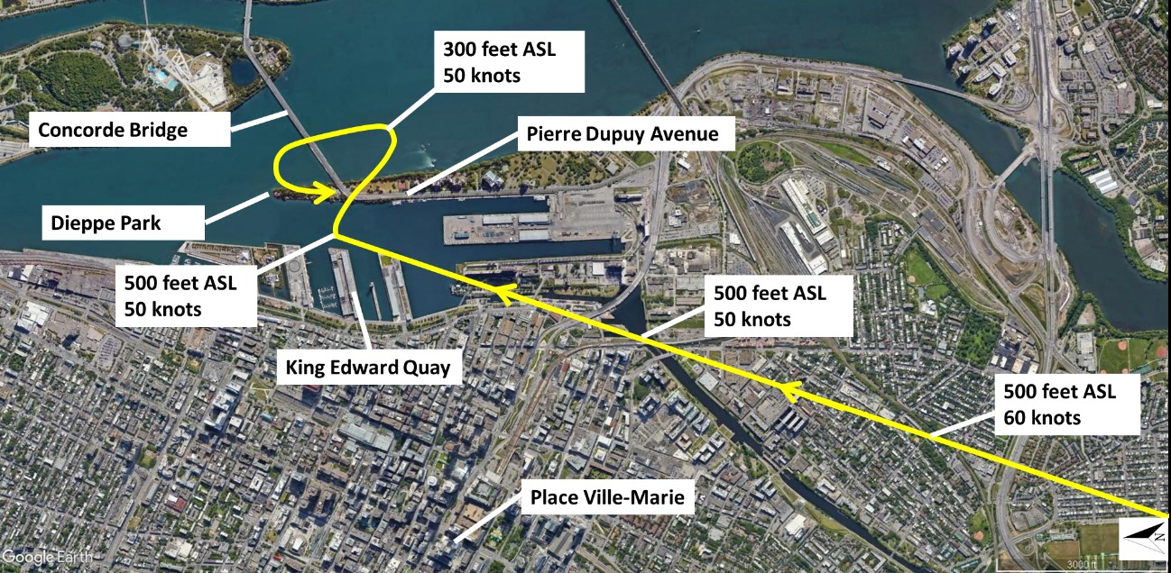
A MAYDAY distress call was sent to the Montréal tower at 1759:45. Shortly after the call, the pilot lined up for landing. The aircraft’s left wing grazed some treetops, the aircraft began to cartwheel, and then it struck the ground. A post-impact fire broke out just under a minute after impact. The pilot, who was in the left seat, was seriously injured but managed to evacuate the aircraft. The passenger, who was in the right seat, was unable to evacuate the aircraft and received fatal injuries. The aircraft was destroyed. No signal was detected from the emergency locator transmitter. Emergency services, who had been alerted by several individuals who had witnessed the accident, arrived at the scene shortly afterward.
1.2 Injuries to persons
The pilot and 1 passenger were on board. Table 1 outlines the degree of injuries received.
| Degree of injury | Crew | Passengers | Persons not on board the aircraft | Total by injury |
|---|---|---|---|---|
| Fatal | 0 | 1 | – | 1 |
| Serious | 1 | 0 | – | 1 |
| Minor | 0 | 0 | – | 0 |
| Total injured | 1 | 1 | – | 2 |
1.3 Damage to aircraft
The aircraft was destroyed by the fire that began shortly after impact with the ground.
1.4 Other damage
The occurrence took place in Dieppe Park, at the northern tip of Cité du Havre in Montréal’s Ville-Marie borough. Some trees were damaged during the impact sequence.
Because of the post-impact fire, the investigation was unable to determine how much fuel was spilled.
1.5 Personnel information
The pilot held a commercial pilot licence – aeroplane issued in September 2006 and a medical certificate that had just expired the day before the occurrence. The pilot was therefore no longer entitled to exercise the privileges of his licence, as stipulated in the Canadian Aviation Regulations (CARs):
404.03(1) No person shall exercise or attempt to exercise the privileges of a permit, licence or rating unless the person holds a valid medical certificate of a category that is appropriate for that permit, licence or rating, as specified in section 404.10.Footnote 4
| Pilot licence | Commercial pilot licence (CPL) |
|---|---|
| Medical expiry date | 01 October 2021 |
| Total flying hours | 6400 |
| Flight hours on type | 2500 |
| Flight hours towing banners | 2900 |
| Flight hours towing gliders | 100 |
1.6 Aircraft information
| Manufacturer | Cessna Aircraft Company |
|---|---|
| Type, model and registration | Cessna 172M, C-FFRV |
| Year of manufacture | 1974 |
| Serial number | 17262394 |
| Certificate of airworthiness/flight permit issue date | 22 April 2009 |
| Total airframe time | 4049.4 |
| Engine type (number of engines) | Avco Lycoming O-320-E2D (1) |
| Propeller type (number of propellers) | McCauley 1C160/DTM (1) |
| Maximum allowable take-off weight | 1043 kg (2300 lb) |
| Recommended fuel type(s) | 100/130, 100 LL |
| Fuel type used | 100 LL |
The last maintenance work on the occurrence aircraft was carried out on 04 August 2021 for a 200-hour recurrent inspection. At the time of the inspection, the engine had accumulated 427.5 hours since its installation in July 2013.
Records indicate that there were no deferred defects at the time of the occurrence. There was no indication of a mechanical engine failure or malfunction of a system before or during the flight.
1.6.1 Emergency procedures
The Cessna 172M Pilot’s Operating Handbook states the procedure to be followed in the event of engine failure in flight:
(1) Airspeed -- 65 KIAS [knots indicated airspeed].
(2) Carburetor Heat -- ON.
(3) Fuel Selector Valve -- BOTH.
(4) Mixture -- RICH.
(5) Ignition Switch -- BOTH (or START if propeller is stopped).
(6) Primer – IN and LOCKED.Footnote 5
In addition, section 3 of the handbook provides a table of gliding distances, indicating that a Cessna 172M gliding at a speed of 65 KIAS, with propeller windmilling, flaps up, in calm winds, would cover a distance of 3 statute miles (SM) for every 2000 feet of altitude above ground level (AGL) or a gliding distance of approximately 0.75 NM from a starting altitude of 500 feet AGL. This section also provides amplified procedures and states that, in the event of an engine failure after takeoff,
[p]rompt lowering of the nose to maintain airspeed and establish a glide attitude is the first response to an engine failure after takeoff. In most cases, the landing should be planned straight ahead with only small changes in direction to avoid obstructions. Altitude and airspeed are seldom sufficient to execute a 180° gliding turn necessary to return to the runway. The checklist procedures assume that adequate time exists to secure the fuel and ignition prior to touchdown
After an engine failure in flight, the best glide speed […] should be established as quickly as possible.Footnote 6
1.7 Meteorological information
1.7.1 Graphic area forecasts
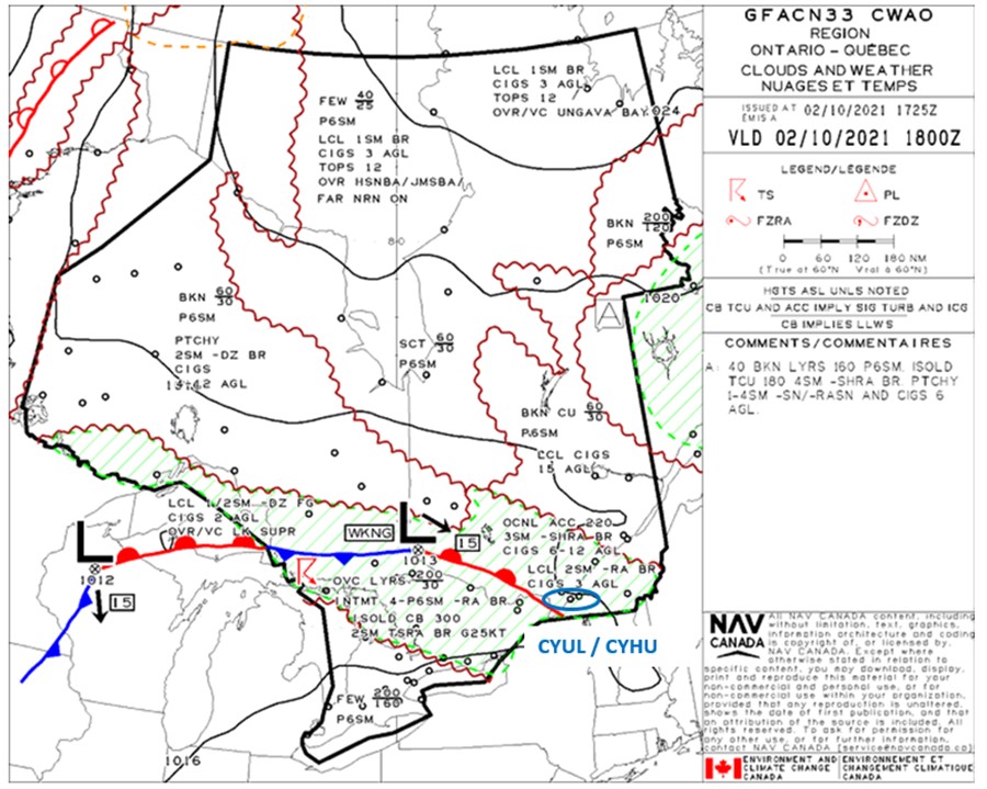
Graphic area forecasts (GFA) indicate the future weather conditions for a given geographic area.Footnote 7 On the day of the occurrence, a Clouds and Weather chart, issued at 1325 and valid as of 1400, showed a weakening low-pressure system to the north of North Bay, Ontario, moving southeast at a speed of 15 knots. This system included a warm front extending along the Quebec–Ontario border, on the Quebec side (Appendix A).
The forecast conditions ahead of the warm front, near the route of the occurrence flight were as follows:
- occasional altocumulus castellanus with tops at 22 000 feet ASL;
- visibility of 3 SM;
- light rain showers;
- mist; and
- ceilings varying between 600 and 1200 feet AGL.
The GFA also indicated the following local conditions for the same area:
- visibility of 2 SM;
- light rain;
- mist; and
- ceiling at 300 feet AGL.
1.7.2 Aerodrome routine meteorological reports
1.7.2.1 Montréal/Pierre Elliott Trudeau International Airport
Aerodrome routine meteorological reports (METARs) for CYUL are based on observations made by a qualified human observer.
The METAR for CYUL issued at 1700 on 02 October 2021 indicated the following:
- winds from 050° true (T) at 8 knots;
- visibility of 15 SM;
- light drizzle;
- few clouds at 800 feet AGL, broken ceiling at 1400 feet AGL, and an overcast cloud layer at 2200 feet AGL;
- temperature 12 °C and dew point 12 °C;
- altimeter setting 29.98 inches of mercury; and
- remarks on cloud layers: 1/8 stratus fractus, 5/8 stratocumulus, 2/8 stratocumulus.Footnote 8
A table of METARs issued for CYUL for the hours leading up to the flight can be found in Appendix B of this report.
1.7.2.2 Montréal/St-Hubert Airport
METARs for CYHU are based on observations recorded by an automated weather observation system (AWOS) and are referred to as AUTO METARS.
The AUTO METAR for CYHU issued at 1700 on 02 October 2021 indicated the following:
- winds from 040°T at 6 knots;
- visibility of 3 SM;
- light rain;
- mist;
- broken ceiling at 900 feet AGL, broken clouds at 1400 feet AGL and an overcast cloud layer at 2100 feet AGL;
- temperature 12 °C and dew point 12 °C; and
- altimeter setting 29.98 inches of mercury.
A table of METARs issued for CYHU for the hours leading up to the flight can be found in Appendix C of this report.
1.7.3 Aerodrome forecasts
Aerodrome forecasts (TAFs) provide a description of the most probable weather conditions within a radius of 5 NM around an aerodrome. They are modified as necessary to reflect improvements or deteriorations in current or forecast conditions.
1.7.3.1 Montréal/Pierre Elliott Trudeau International Airport
The TAF for CYUL issued at 1638 on 02 October 2021 and valid from 1700 on 02 October until 1400 on 03 October, forecast the following conditions:
- winds from 050°T at 8 knots;
- visibility of 4 SM;
- light rain;
- mist;
- broken ceiling at 700 feet AGL; and
- overcast cloud layer at 1200 feet AGL.
The TAF forecast the temporary changes (TEMPO) below from 1700 on 02 October until 1000 on 03 October:
- visibility of 6 SM;
- light rain;
- light drizzle;
- mist;
- scattered clouds at 700 feet AGL;
- broken ceiling at 1200 feet AGL; and
- overcast cloud layer at 2000 feet AGL.
The TAF forecast the permanent changes below effective 1000 on 03 October:
- winds from 040°T at 12 knots;
- visibility greater than 6 SM;
- light rain;
- broken ceiling at 1200 feet AGL; and
- overcast cloud layer at 3000 feet AGL.
1.7.3.2 Montréal/St-Hubert Airport
The TAF for CYHU issued at 1339 on 02 October 2021 and valid from 1400 on 02 October until 1400 on 03 October, forecast the following conditions:
- winds from 080°T at 7 knots;
- visibility of 4 SM;
- light rain;
- mist; and
- overcast ceiling at 700 feet AGL.
The TAF forecast the temporary changes (TEMPO) below from 1400 on 02 October until 1000 on 03 October:
- visibility of 6 SM;
- light rain;
- light drizzle;
- mist;
- scattered clouds at 700 feet AGL;
- broken ceiling at 1200 feet AGL; and
- overcast cloud layer at 3000 feet AGL.
The TAF forecast the permanent changes below effective 1000 on 03 October:
- winds from 030°T at 12 knots;
- visibility greater than 6 SM;
- light rain;
- broken ceiling at 1200 feet AGL; and
- overcast cloud layer at 3000 feet AGL.
1.8 Aids to navigation
1.8.1 Visual flight rules terminal procedures chart
Aeronautical information required for VFR flight that cannot be depicted on visual aeronautical charts is published in the Canada Flight Supplement (CFS). When important information about an aerodrome cannot be adequately described in the sketch or text normally used in the CFS, a VFR terminal procedures chart (VTPC) is added to the pages pertaining to that aerodrome.
A VTPC depicts all VFR call-up points as well as VFR checkpoints where pilots must report to ATC before entering the control zone. The chart also depicts routes that are to be followed by VFR fixed-wing aircraft flying into and out of the control zone.
1.8.1.1 Ville-Marie sightseeing circuit
The Ville-Marie sightseeing circuit VTPC, which depicts the route to be followed when flying over the city of Montréal within CYUL and CYHU controlled airspace, does not indicate a minimum altitude.
However, the procedures for the Ville-Marie sightseeing circuit described in the CFS state that pilots must “maintain the [altitude] assigned by the Montréal Control Tower.”Footnote 9 The procedures also state that banner-towing and aerial photography flights “should be coordinated with the Montréal Control Tower supervisor […] with at least 1 [hour] prior notice.”Footnote 10
1.9 Communications
At the time of the occurrence, the pilot was communicating with the Montréal Control Tower. A MAYDAY distress call was received on the tower frequency at 1759:45, moments before the aircraft struck the ground.
1.10 Aerodrome information
Not applicable.
1.11 Flight recorders
The aircraft was not equipped with a flight data recorder or a cockpit voice recorder, nor was either required by regulation.
1.12 Wreckage and impact information
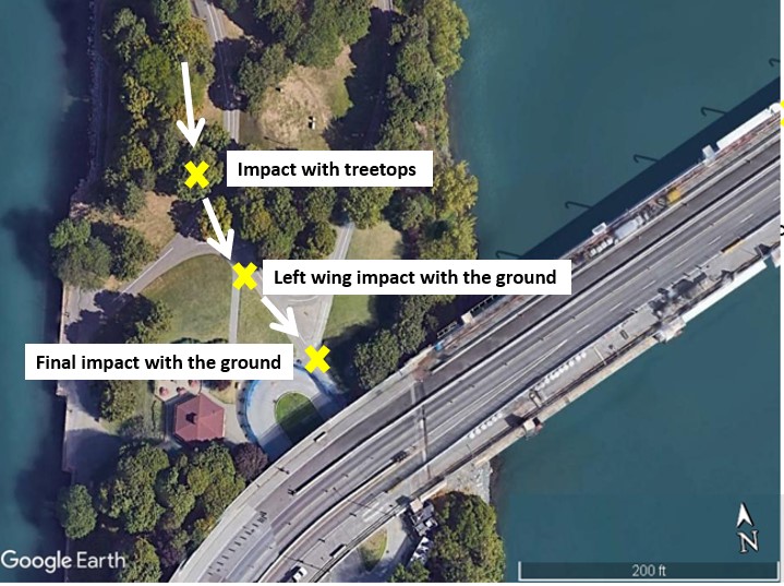
The accident occurred in Dieppe Park, in Montréal’s Ville-Marie borough. During the impact sequence, the left wing grazed treetops, the aircraft began to cartwheel, and then it struck the ground.
Broken branches on 2 trees near the west bank of Dieppe Park identified where the aircraft’s initial impact took place, just north of the bend that connects the west tip of the Concorde Bridge to the start of Pierre-Dupuy Avenue. There was a short distance between the damaged trees and the ground scars left by the left wing and propeller, which were found in a section of the park where there were no trees. Based on the wreckage distribution pattern, the aircraft was flying southward when it made initial contact with the trees before quickly deviating to the southeast. The aircraft came to rest on a concrete flower bed, about 10 m from the ground scar left by the propeller. At the end of the impact sequence, the aircraft was resting in one piece, on its nose, with its belly lying on the concrete flower bed, facing southwest (Figure 2).
The fire that broke out consumed the aircraft’s entire fuselage, sparing parts of the wings and the empennage, which had fallen to the ground. The damage to the left wing was consistent with the impact with the trees and the ground. Although there was a fuel leak after the impact, there was still fuel in the wing tanks. Given the amount of damage to the wreckage, the investigation was unable to determine the position of the ancillary controls (carburetor heat and mixture) or the throttle.
1.12.1 Analysis of the engine and propeller
The engine and propeller were sent to the TSB Engineering Laboratory in Ottawa, Ontario, for analysis. There was no indication of a deficiency that could have prevented the engine from working properly before the impact. The damage to the crankshaft and propeller flange was consistent with a heavy impact with a hard surface. The absence of torsional signatures at the crankshaft fracture surface, coupled with the marks on the propeller, are indicative of low engine power at impact.
1.13 Medical and pathological information
According to information gathered during the investigation, there was no indication that the pilot’s performance was affected by medical or physiological factors.
1.14 Fire
The aircraft caught on fire after striking the ground. The cabin area was destroyed by the fire. Given the destructive nature of the fire, it was impossible to determine how it started or how it spread.
1.15 Survival aspects
Given the extensive damage caused by the fire, TSB investigators were unable to determine the extent of the deformations to the livable space when the aircraft cartwheeled and when it struck the ground. Given that the aircraft struck the ground in a left-bank attitude, the left side experienced more abrupt acceleration than the right side. The pilot, who was sitting on the left side, was able to evacuate the aircraft despite his injuries. The passenger, who was sitting on the right side, was thrown to the left side when the aircraft cartwheeled; he was unable to evacuate the aircraft. Despite his efforts, the pilot was unable to help the passenger get out of the aircraft before it caught on fire.
1.15.1 Use of safety belts and restraints
The CARs contain several provisions requiring the use of safety belts, restraints and, if applicable, shoulder harnesses. Specifically, section 605.25 of the CARs stipulate the following with respect to the general use of safety belts:
(1) The pilot-in-command of an aircraft shall direct all of the persons on board the aircraft to fasten safety belts, including any shoulder harness,
(a) during movement of the aircraft on the surface;
(b) during take-off and landing; and
(c) at any time during flight that the pilot-in-command considers it necessary that safety belts be fastened.Footnote 11
In addition, section 605.27 of the CARs stipulate the following regarding the use of safety belts by flight crew members:
(3) The pilot-in-command shall ensure that at least one pilot is seated at the flight controls with safety belt, including any shoulder harness, fastened during flight time.Footnote 12
Although the occurrence aircraft’s seats were equipped with safety belts consisting of a lap belt and shoulder harness,Footnote 13 the 2 occupants were wearing only their lap belts during the occurrence flight. According to a U.S. Federal Aviation Administration (FAA) research paper on restraint systems, “[a]mong all possible types of injury occurring in potentially survivable accidents, those most frequently occurring result from the partially restrained or wholly unrestrained occupant’s [sic] striking surrounding structures.”Footnote 14
The shoulder harness is an important part of an aircraft occupant’s protection system, and wearing a shoulder harness is known to reduce the likelihood and severity of injuries. A major advantage of using a shoulder harness is that it minimizes body movements and ensures that the body does not strike the aircraft’s structure during lateral and longitudinal impacts.Footnote 15 Transport Canada (TC) states the following in its Advisory Circular (AC) 605-004:
(1) A high percentage of pilot and passenger deaths and serious injuries have occurred in small aircraft accidents and have been attributed to the pilot’s head making contact with the aircraft’s control yoke, instrument panel or other parts of the flight deck structure, or the passenger’s head making contact with the seat in front of them. This is due to the unrestrained upper body flailing around in the absence of a shoulder harness during the crash sequence.
(2) Accident statistics provide substantial evidence that the use of a shoulder harness, in conjunction with a lap strap, can reduce serious injuries to the head, neck, and upper torso for occupants on board an aircraft, and has the potential to reduce fatalities of occupants in an otherwise survivable accident.Footnote 16
The TSB has investigated many accidentsFootnote 17 involving aircraft that were equipped with detachable shoulder harnesses, in which the harnesses were not being worn at the time of the accident. Following an accident involving an Airbus Helicopters AS 350 B2 helicopter on 14 December 2017 in Tweed, Ontario,Footnote 18 the TSB investigation determined that the passengers’ shoulder harnesses were not used with the lap belts. Based on the definition of “safety belt” in the CARs, the company had considered that it would be in compliance with the regulations if the occupants wore either the lap belt alone, or the lap belt combined with the shoulder harness. Therefore, the Board recommended that
the Department of Transport amend the Canadian Aviation Regulations to remove any ambiguity associated with the definition of “safety belt”.
TSB Recommendation 000Footnote 19
On 07 July 2021, TC published amendments to the relevant sections of CARs Subpart 605. The amendments included new wording to remove any ambiguities pertaining to the use of safety belts, and to clarify that safety belts, including shoulder harnesses, must be fastened. In March 2022, the Board assessed TC’s response to Recommendation A19-01 to be Fully Satisfactory and closed the recommendation.
1.16 Tests and research
1.16.1 TSB laboratory reports
The TSB completed the following laboratory reports in support of this investigation:
- LP131-2021 – Engine and Propeller Examination
- LP138-2021 – Radar Data Analysis
- LP144-2021 – Audio Analysis
- LP149-2021 – Video Analysis
1.17 Organizational and management information
AEROGRAM is a company based at Saint-Hubert, Quebec, that specializes in banner-towing flights and has been in business for more than 25 years. At the time of the occurrence, AEROGRAM was operating 1 Piper PA-18 and 1 Cessna 172M in accordance with an air operator certificate issued by TC for operations conducted under CARs subparts 702 (Aerial Work) and 703 (Air Taxi Operations).Footnote 20 The occurrence flight was an aerial work flight, conducted under CARs Subpart 702. At the time of the occurrence, the pilot was the owner of the company and was also acting as operations manager, chief pilot, and maintenance coordinator.
Aerial work covers a wide range of operations, some of which require an air operator certificate, as is the case for towing objects such as banners.Footnote 21 Although a person other than a flight crew member may be on board during aerial work, that person’s presence on board must be essential to the flight. Otherwise, their presence must be authorized in the air operator certificate.Footnote 22
The Commercial Air Service Standards (CASS) Standard 722 states the requirements that must be met “for authorization to carry persons other than a flight crew member and persons essential during the flight,”Footnote 23 including the following:
(a) the person is a flight crew member trainee, is a person undergoing training for essential duties during flight or is an air operator employee aircraft maintenance technician; […]
(c) the person is being carried to an aerial work site, performs an essential function in connection with the aerial work operation and is necessary to accomplish the aerial work operation; […]
(e) aircraft equipment requirements comply with Subpart 605 of the Canadian Aviation Regulations, Division II - Aircraft Equipment Requirements for aircraft seats, restraint system requirements and shoulder harness requirements, as applicable; and
(f) persons are safety briefed in accordance with section 722.23 of the Aerial Work Standard.Footnote 24
The person occupying the right seat on the occurrence flight did not meet the requirements to be considered essential to a flight, and AEROGRAM did not have the special authorization required for carrying persons.
1.18 Additional information
1.18.1 Minimum altitudes and distances
Subsection 602.14(2) of the CARs states the minimum altitudes and distances for a flight over a built-up area:
(2) Except where conducting a take-off, approach or landing or where permitted under section 602.15, no person shall operate an aircraft
(a) over a built-up area or over an open-air assembly of persons unless the aircraft is operated at an altitude from which, in the event of an emergency necessitating an immediate landing, it would be possible to land the aircraft without creating a hazard to persons or property on the surface, and, in any case, at an altitude that is not lower than:
(i) for aeroplanes, 1,000 feet above the highest obstacle located within a horizontal distance of 2,000 feet from the aeroplane, […]
(b) in circumstances other than those referred to in paragraph (a), at a distance less than 500 feet from any person, vessel, vehicle or structure.Footnote 25
The occurrence aircraft was not authorized under section 602.15 of the CARs to conduct the flight at an altitude or distance less than that stated in section 602.14.
1.18.2 Minimum altitudes and distances for visual flight rules flights
Section 602.114 of the CARs states the minimum meteorological conditions for VFR flight in controlled airspace:
No person shall operate an aircraft in VFR flight within controlled airspace unless
(a) the aircraft is operated with visual reference to the surface;
(b) flight visibility is not less than three miles;
(c) the distance of the aircraft from cloud is not less than 500 feet vertically and one mile horizontally; and
(d) where the aircraft is operated within a control zone,
(i) when reported, ground visibility is not less than three miles, and
(ii) except when taking off or landing, the distance of the aircraft from the surface is not less than 500 feet.Footnote 26
If weather conditions do not allow a pilot to meet the minimum conditions set out in section 602.114 of the CARs, ATC may still clear the aircraft to fly within the control zone if the pilot makes the request. The conditions for a VFR special flight are stated in subsection 602.117(1):
Despite paragraph 602.114(b), an aircraft may be operated in special VFR flight within a control zone if
(a) weather conditions preclude compliance with paragraph 602.114(b);
(b) flight visibility is not less than
(i) one mile, where the aircraft is not a helicopter, or
(ii) one-half mile, where the aircraft is a helicopter;
(c) the aircraft is operated clear of cloud and with visual reference to the surface at all times; and
(d) authorization to do so has been requested and obtained from the appropriate air traffic control unit.Footnote 27
The pilot is responsible for remaining within VFR flight conditions at all times (Figure 3). No VFR special flight authorization request had been received or issued by the Montréal Control Tower for the occurrence flight.
![Illustration showing minima for meteorological references (Source: Aviation Publishers Co. Ltd., From the Ground Up, 29th Edition [2021], section 5.2.9: Weather Minima for VFR Flight, Fig. 4)](/sites/default/files/eng/rapports-reports/aviation/2021/a21q0092/images/a21q0092-figure-03.jpg)
1.18.3 Pilot decision making
Pilot decision making is a cognitive process consisting of gathering information, evaluating it, then selecting an option between alternatives. Once a course of action is being performed, the decision-making process starts again in order to validate whether the decision made corresponds to the best possible option. Decision making is therefore a dynamic process. By anticipating and addressing possible issues that could occur during the flight, pre-flight planning decisions avoid the need for potentially more difficult in-flight decisions.
According to an educational package from TCFootnote 28 on the subject, pilot decision making varies depending on how much time the pilot has to act:
- Before the flight, there is “ample time decision making.”
- During the flight, there is “time critical decision making,” since a quick decision and reaction are necessary, often based on similar previous experience or one that was simulated during training.
Other factors may have an impact on pilot decision making, such as the pressure to conduct a flight within a scheduled timeframe and the financial repercussions if a contract is cancelled. In this occurrence, the flight, which was being conducted to display a marriage proposal, had to be conducted before the client’s scheduled departure on the afternoon of 03 October.
1.18.3.1 Plan continuation bias
A number of cognitive biases can also influence pilot decision making. Plan continuation bias is best described as “the unconscious cognitive bias to continue with the original plan in spite of changing conditions,”Footnote 29 or “a deep-rooted tendency of individuals to continue their original plan of action even when changing circumstances require a new plan.”Footnote 30 Once a plan is made and committed to, it becomes increasingly difficult for stimuli or conditions in the environment to be recognized as necessitating a change to that plan. Often, as workload increases, the stimuli or conditions will appear obvious to people external to the situation; however, it can be very difficult for a pilot caught up in the plan to recognize the saliency of the cues and the need to alter the plan.Footnote 31 Plan continuation bias can be a factor for continued flight in adverse weather conditions.
In this occurrence, the pilot had planned to conduct the flight at an altitude of 1200 feet ASL, but due to lower clouds, the flight remained at an average altitude of 500 feet ASL, reducing the safety margin available in an emergency.
1.18.4 Carburetor icing
In an internal combustion engine, such as the one in the occurrence aircraft, the combustion process in the cylinder is based on mixing fuel and air to achieve optimal performance. To do so, the carburetor converts liquid fuel into vapour and then mixes the vapour with air to make it combustible.
Carburetor icing is a phenomenon where water vapour in the air freezes and adheres to internal surfaces of the carburetor (Figure 4). This occurs because the temperature of the air entering the carburetor is reduced by the effect of fuel vaporization and by the decrease in air pressure caused by the Venturi effect. If the air temperature in the carburetor drops below freezing, ice may form on internal surfaces of the carburetor, including the throttle valve. As ice forms, this increases the Venturi cooling effect due to narrowing of the carburetor throat. This narrowing limits the flow of the fuel-air mixture, reducing the power output. Carburetor icing usually results in a loss of power and engine roughness. If enough ice accumulates, it can cause an engine failure.
![Illustration showing how the formation of carburetor icing can restrict or prevent the fuel-air mixture from flowing to the engine (Source: Aviation Publishers Co. Ltd., From the Ground Up, 29th Edition [2021], section 3.3.5: Carburetor Icing, Figure 26.)](/sites/default/files/eng/rapports-reports/aviation/2021/a21q0092/images/a21q0092-figure-04.jpg)
Wet weather and a temperature between −5 °C and +30 °C are favourable for the formation of carburetor icing. The manual From the Ground Up states that:
Liquid gasoline must be changed into a vapour and mixed with air to become combustible. This process occurs in the carburetor. The heat that is required to change the liquid gasoline to a vapour is absorbed from the air that passes through the carburetor and into the manifold. Thus, the carburetor is, in effect, a miniature refrigerator, the temperature in this mixing chamber dropping as much as 30 degrees Celsius below the temperature of the incoming air.
If this air contains large amounts of moisture (air always contains some water vapour), the cooling process will cause the water vapour to condense and possibly freeze on all surfaces of the carburetor but especially on the throttle butterfly. It is possible for this icing condition to occur with outside air temperatures as high as 30°C, in bright sunshine with no sign of rain. A temperature of around 15°C should be regarded as the most suspect. The minimum relative humidity generally necessary for icing to occur is 50%, with the icing hazard increasing as the humidity increases.Footnote 32
To help determine whether atmospheric conditions are likely to produce carburetor ice, charts that compare outside ambient temperature and dew point have been produced (Figure 5).
![Diagram showing carburetor icing in relation to atmospheric conditions (Source: Transport Canada, TP 14371, Transport Canada Aeronautical Information Manual [TC AIM], AIR – Airmanship [25 March 2021], section 2.3, with TSB annotations.)](/sites/default/files/eng/rapports-reports/aviation/2021/a21q0092/images/a21q0092-figure-05.jpg)
According to the above diagram, the temperature and dew point in the Montréal area at the time of the occurrence were conducive to serious carburetor icing at any power.
1.18.4.1 Prevention of carburetor icing
To avoid carburetor icing, aircraft are equipped with a device that heats incoming air to prevent ice buildup. The carburetor heating control channels the heated air to the carburetor air intake to maintain the fuel–air mixture above the freezing point and avoid the formation of ice in the carburetor (Figure 6). Ideally, this is done as a preventive measure. However, once ice has formed in the carburetor, the carburetor heat must be turned on to melt it.
![Carburetor heating system (Source: Aviation Publishers Co. Ltd., From the Ground Up, 29th Edition [2021], section 3.3.5: Carburetor Icing, Figure 26.)](/sites/default/files/eng/rapports-reports/aviation/2021/a21q0092/images/a21q0092-figure-06.jpg)
The first signs of carburetor icing are a loss of power and engine roughness. Carburetor heat causes an additional power reduction because the hot air coming into the carburetor is less dense than the outside air, so the fuel–air mixture is enrichened.
Also, if a large amount of ice forms in the carburetor and the carburetor heat is set to maximum to melt it, the additional water generated by the melting ice begins to flow through the engine. The engine loses even more power, sputters more often, and may even stall. The loss of power and engine roughness may last from 30 seconds to several minutes, depending on the severity of the icing. The pilot must keep the heat at maximum until power returns to normal and resist the temptation to decrease the heat before that point.Footnote 33 If no action is taken to eliminate the ice buildup, the engine can quickly experience complete failure.
In this occurrence, the carburetor heat was turned on at the first signs of carburetor icing. After the carburetor heat had been turned on, the engine appeared to regain a bit of power, but then it sputtered again and there was another loss of power.
Ice that forms in a carburetor during flight is rarely still present after a crash. However, accidents and incidents related to carburetor icing occur frequently in aviation: between 2005 and 2021, the TSB released 4 investigation reports in which this phenomenon was cited as a cause.Footnote 34
1.18.5 Forced landing
In many ways, the altitude available for an emergency landing is a factor that determines whether the outcome is successful. In the occurrence flight, the loss of engine power happened when the aircraft was flying at low speed and high rpm in level flight approximately 500 feet ASL, which meant the action to be taken was similar to what is required in the event of engine failure after takeoff, leaving little time for the pilot to assess the situation.
At the time, the aircraft was flying over the St. Lawrence River at low altitude. The pilot then decided to try to land on the Concorde Bridge. However, there was construction on the bridge, so the pilot had 2 options: he could continue on a path for a water landing, with only slight corrections required to the heading, or he could turn to land on Pierre-Dupuy Avenue.
The TC Flight Training Manual states that:
Numerous fatal accidents have resulted from attempting to turn back and land on the runway or aerodrome following an engine failure after take-off. As altitude is at a premium, the tendency is to try to hold the nose of the aircraft up during the turn without consideration for airspeed and load factor. These actions may induce an abrupt spin entry. [An attempt to turn back to the runway or aerodrome may be successful under certain conditions.Footnote 35] Experience and careful consideration of the following factors are essential to making a safe decision to execute a return to the aerodrome:
- Altitude.
- The glide ratio of the aircraft.
- The length of the runway.
- Wind strength/ground speed.
- Experience of the pilot.
- Pilot currency on type.Footnote 36
When a flight takes place over an area that is not suitable for a forced landing, pilots benefit from having a plan for dealing with an emergency. The plan should take into account several factors, including terrain, altitude, the aircraft’s glide ratio, wind strength, and in the occurrence flight, the additional drag from the banner. It must also include the minimum altitude at which a 180° turn could be attempted in order to return to the take-off point after an engine failure or, as in the occurrence flight, to attempt a 180° turn to land on a road.
During the final turn, the aircraft’s left wing grazed treetops. There was no indication of an engine stall or the aircraft entering a spin.
2.0 Analysis
The pilot held the appropriate licence and ratings for the flight. However, his medical certificate had been expired since 01 October 2021—the day before the accident—which prohibited him from exercising the privileges of his licence and ratings. There was no indication that the pilot’s performance was affected by fatigue or any other medical or physiological factors.
An examination of the aircraft’s engine and technical records did not reveal any mechanical issues likely to have caused a total or partial power loss.
Consequently, the analysis will focus on the following points:
- flight planning;
- pilot decision making;
- carburetor icing;
- forced landing procedure; and
- survival aspects .
2.1 Flight planning
The occurrence pilot had contacted the Québec flight information centre (FIC) to obtain the weather conditions forecast for the Montréal area. He had also rechecked the weather observations before he arrived at the aerodrome to prepare for the flight.
The cloud ceilings in the last aerodrome routine meteorological reports (METARs) were at 1400 feet above ground level (AGL) for the Montréal/Pierre Elliott Trudeau International Airport (CYUL) and at 900 feet AGL for the Montréal/St-Hubert Airport (CYHU). Scattered clouds were also reported at 800 feet AGL at CYUL.
The most recent aerodrome forecasts (TAFs) for CYUL and CYHU, valid at the time of the flight, were forecasting cloud ceilings at 700 feet AGL; however, both TAFs were also forecasting that conditions would improve temporarily during the time period in question. The most recent graphic area forecast (GFA) was forecasting an overcast cloud layer between 600 and 1200 feet AGL ahead of the warm front, with the possibility of a local ceiling at 300 feet AGL.
2.2 Pilot decision making
Pre-flight planning reduces a pilot’s risk of making decision errors in flight because it can help to prepare the pilot for situations that might arise during the flight. Without planning, the pilot might need to make decisions in high-stress situations, increasing the risk of inappropriate or incorrect decisions being made.
When weather conditions deteriorate during a flight, or are not as expected, pilots must manage the associated risks appropriately as their workload increases. Furthermore, they must be aware when conditions are no longer suitable for proceeding with a flight and take decisive action.
To meet the minimum weather conditions for VFR flight in controlled airspace, the aircraft had to maintain the required minimum distances from cloud: 500 feet vertically and at least 1 mile horizontally. However, during the occurrence flight, the pilot, who had planned to fly at an altitude of 1200 feet above sea level (ASL), stated in his communications with the Montréal and St-Hubert control towers that he was waiting to be clear of the clouds to climb to the planned altitude, yet he continued to head toward his target point at an altitude of 500 feet ASL.
Plan continuation bias is an unconscious cognitive bias to continue with the original plan despite changing conditions. Once a person has made a plan and is committed to following the plan, it becomes increasingly difficult for the person to recognize stimuli or conditions that suggest the need to change the plan, particularly during periods of high workload.
In addition, on the occurrence flight, factors such as pressure to complete the flight within the scheduled timeframe (before the client’s departure the following day) and the purpose of the flight (a marriage proposal) could have influenced the decision to conduct and continue with the planned flight even though the weather conditions were poor.
Finding as to causes and contributing factors
During flight planning, weather forecasts indicated unfavourable conditions, making it difficult to meet the minimum requirements for a VFR flight; however, the pilot decided to take off and proceed with the flight at an altitude of 500 feet ASL, likely under the influence of an unconscious cognitive bias and the time constraints to complete the flight.
2.3 Carburetor icing
The engine teardown did not reveal any mechanical issues associated with the loss of power.
Given the temperature and dew point in the Montréal area at the time of the occurrence, conditions were conducive to severe carburetor icing, regardless of the engine speed. Furthermore, the presence of precipitation meant that there was a relatively high amount of atmospheric moisture, and an increased risk of severe carburetor icing. Carburetor icing generally causes a loss of power and engine roughness. During the occurrence flight, the pilot turned on the carburetor heat at the first signs of carburetor icing, but the engine had an additional loss of power.
Finding as to causes and contributing factors
Atmospheric conditions conducive to carburetor icing most likely caused ice to develop, which would have reduced the engine’s ability to produce enough power to maintain the aircraft‘s altitude.
When ice forms in the carburetor, the carburetor heat initially causes a sharp loss of power and engine roughness. If a large amount of ice forms in the carburetor and the carburetor heat is set to maximum to melt the ice, the additional water generated by the melting ice flows through the engine. The pilot can expect it to take some time, from 30 seconds to several minutes, before the ice is melted. During that time, the engine may lose even more power, sputter even more, and perhaps even stall.
Finding as to causes and contributing factors
Given the amount of ice that was quite likely in the carburetor when the carburetor heat was turned on, the melted ice entered the engine in the form of water, causing an additional loss of power.
2.4 Forced landing
During flight, when a mechanical issue arises that requires an immediate landing, pilots find themselves in a situation where they can attempt a forced landing in an unsuitable location, at the risk of damaging the aircraft and receiving injuries, or they can attempt a turn toward a location that is deemed safer.
The occurrence flight was conducted primarily over a built-up area, and due to the clouds, the pilot could not maintain the minimum altitude of 1000 feet above the highest obstacle located 2000 feet or less from the aircraft horizontally. Therefore, in the event of an emergency requiring an immediate landing, his chances of conducting a landing without creating a hazard to people or property on the surface were reduced.
The loss of power occurred while the aircraft was flying over the St. Lawrence River at low altitude. The pilot then attempted to land on the Concorde Bridge. However, there was construction on the bridge, so the pilot had 2 options: continue on a path for a landing on the river, with only slight corrections required to the heading, or attempt to continue the turn and land on Pierre-Dupuy Avenue.
Finding as to causes and contributing factors
To remain within VFR conditions, the pilot continued the flight at an altitude of 500 feet ASL, flying over built-up areas. Consequently, when the engine lost power, the possible locations for a safe landing were considerably limited .
In this occurrence, in addition to the low altitude at which the aircraft was flying when the engine failure took place, the pilot had to take into consideration the aircraft’s reduced speed in flight, the additional drag caused by the banner, and the aircraft’s rate of descent. When the pilot began the turn, the aircraft was at an altitude of approximately 400 feet ASL, leaving little leeway to conduct a turn and land on Pierre-Dupuy Avenue.
Finding as to causes and contributing factors
After the loss of engine power at low altitude, the aircraft turned left to attempt to land on Pierre-Dupuy Avenue. While the aircraft was in the turn, the left wing grazed treetops, the aircraft began to cartwheel, and it struck the ground. There was a post-impact fire, and the aircraft was destroyed.
2.5 Survival aspects
Regulations regarding the use of safety belts in Canada require that safety belts, including shoulder harnesses, if applicable, be worn during ground movements, takeoffs and landings, and, for the pilot sitting at the flight controls, throughout the flight. However, passengers are not required to wear the shoulder harness during the en-route portion of the flight.
During the occurrence flight, neither the pilot nor the passenger were wearing their shoulder harness. Although he was injured, the pilot was able to evacuate the aircraft. However, the passenger was unable to evacuate the aircraft and received fatal injuries. Compared to wearing a lap belt alone, wearing both a lap belt and a shoulder harness is known to reduce the likelihood and severity of injuries, particularly flailing injuries to the upper body, in the event of an accident.
Aerial work, carried out in accordance with CARs Subpart 702, covers a wide range of operations, some of which require an air operator certificate, as is the case for towing objects including banners. Although individuals other than flight crew members may, in some cases, be allowed on board during aerial work, their presence must be essential to the flight given the risks involved in this type of work. On the occurrence flight, the passenger did not meet the requirements to be considered essential to the flight, and AEROGRAM did not have the special authorization required for carrying persons.
Finding as to causes and contributing factors
The passenger, who was not considered essential to the flight, was not wearing the shoulder harness at the time of impact, and received fatal injuries upon impact or during the fire that broke out after impact .
3.0 Findings
3.1 Findings as to causes and contributing factors
These are conditions, acts or safety deficiencies that were found to have caused or contributed to this occurrence.
- During flight planning, weather forecasts indicated unfavourable conditions, making it difficult to meet the minimum requirements for a visual flight rules flight; however, the pilot decided to take off and proceed with the flight at an altitude of 500 feet above sea level, likely under the influence of an unconscious cognitive bias and the time constraints to complete the flight.
- Atmospheric conditions conducive to carburetor icing most likely caused ice to develop, which would have reduced the engine’s ability to produce enough power to maintain the aircraft’s altitude.
- Given the amount of ice that was quite likely in the carburetor when the carburetor heat was turned on, the melted ice entered the engine in the form of water, causing an additional loss of power.
- To remain within visual flight rules conditions, the pilot continued the flight at an altitude of 500 feet above sea level, flying over built-up areas. Consequently, when the engine lost power, the possible locations for a safe landing were considerably limited.
- After the loss of engine power at low altitude, the aircraft turned left to attempt to land on Pierre-Dupuy Avenue. While the aircraft was in the turn, the left wing grazed treetops, the aircraft began to cartwheel, and it struck the ground. There was a post-impact fire, and the aircraft was destroyed.
- The passenger, who was not considered essential to the flight, was not wearing the shoulder harness at the time of impact, and received fatal injuries upon impact or during the fire that broke out after impact.
4.0 Safety action
4.1 Safety action taken
The Board is not aware of any safety action taken following this occurrence.
This report concludes the Transportation Safety Board of Canada’s investigation into this occurrence. The Board authorized the release of this report on . It was officially released on .
Appendices
Appendix A – Graphic Area Forecast Clouds and Weather Chart GFACN33 issued at 1325 Eastern Daylight Time on 02 October 2021
Source: Environment and Climate Change Canada, with TSB annotations
Appendix B – Aerodrome routine meteorological reports issued for the Montréal/Pierre Elliott Trudeau International Airport from 1400 to 1700 on 02 October 2021
| Time issued | Wind direction (°T) | Wind speed (knots) | Visibility (SM) | Precipitation | Cloud layers* | Temperature (°C) | Dew point (°C) | Altimeter (inches of mercury) | ||
|---|---|---|---|---|---|---|---|---|---|---|
| First | Second | Third | ||||||||
| 1400 | 070 | 6 | 15 | Light rain | 800 ft; broken clouds | 1300 ft; broken clouds | 3000 ft; overcast | 12 | 11 | 29.98 |
| 1414 | 050 | 7 | 15 | Light rain | 800 ft; scattered clouds | 1200 ft; broken clouds | 2000 ft; overcast | 12 | 11 | 29.97 |
| 1500 | 050 | 9 | 15 | Light rain | 700 ft; few clouds | 1300 ft; broken clouds | 2000 ft; overcast | 12 | 11 | 29.97 |
| 1600 | 040 | 9 | 15 | Light rain | 800 ft; few clouds | 1200 ft; broken clouds | 2000 ft; overcast | 12 | 11 | 29.98 |
| 1652 | 040 | 9 | 15 | Light drizzle | 700 ft; few clouds | 1300 ft; broken clouds | 2200 ft; overcast | 12 | 11 | 29.97 |
| 1700 | 050 | 8 | 15 | Light drizzle | 800 ft; few clouds | 1400 ft; broken clouds | 2200 ft; overcast | 12 | 11 | 29.99 |
* The cloud base is the height above the station in 100-foot increments up to a height of 10 000 feet, then 1000-foot increments. Cloud layers are indicated in eighths (octas) of overcast sky: “few clouds” (FEW) is for summation amounts of less than 1/8 to 2/8; “scattered” (SCT) is from 3/8 to 4/8 summation amount; “broken” (BKN) is from 5/8 to less than 8/8 summation amount; “overcast”(OVC) is 8/8 summation amount.
Appendix C – Aerodrome routine meteorological reports (METARs) issued for the Montréal/St-Hubert Airport from 1400 to 1700 on 02 October 2021
| Time issued | Wind direction (°T) | Wind speed (knots) | Visibility (SM) | Precipitation | Cloud layers* | Temperature (°C) | Dew point (°C) | Altimeter (inches of mercury) | ||
|---|---|---|---|---|---|---|---|---|---|---|
| First | Second | Third | ||||||||
| 1400 | 070 | 5 | 9 | Light rain | 900 ft; broken clouds | 5500 ft; overcast | Nil | 12 | 11 | 29.98 |
| 1449 | 050 | 5 | 9 | Light rain | 1300 ft; overcast | Nil | Nil | 12 | 12 | 29.97 |
| 1500 | 050 | 5 | 7 | Light rain | 900 ft; few clouds | 1300 ft; overcast | Nil | 12 | 12 | 29.97 |
| 1600 | 040 | 5 | 9 | Nil | 2100 ft; overcast | Nil | Nil | 13 | 12 | 29.98 |
| 1640 | 030 | 8 | 9 | Light rain | 900 ft; scattered clouds | 1800 ft; broken clouds | 2400 ft; overcast | 13 | 12 | 29.98 |
| 1700 | 040 | 6 | 3 | Light rain and mist | 900 ft; broken clouds | 1400 ft; broken clouds | 2100 ft; overcast | 12 | 12 | 29.98 |
* The cloud base is the height above the station in 100-foot increments up to a height of 10 000 feet, then 1000-foot increments. Cloud layers are indicated in eighths (octas) of overcast sky: “few clouds” (FEW) is for summation amounts of less than 1/8 to 2/8; “scattered” (SCT) is from 3/8 to 4/8 summation amount; “broken” (BKN) is from 5/8 to less than 8/8 summation amount; “overcast” (OVC) is 8/8 summation amount.