Controlled flight into terrain
Alkan Air Ltd.
Cessna 208B Grand Caravan, C-FSKF
Mayo, Yukon, 25 NM ENE
The Transportation Safety Board of Canada (TSB) investigated this occurrence for the purpose of advancing transportation safety. It is not the function of the Board to assign fault or determine civil or criminal liability. This report is not created for use in the context of legal, disciplinary or other proceedings. See Ownership and use of content. Masculine pronouns and position titles may be used to signify all genders to comply with the Canadian Transportation Accident Investigation and Safety Board Act (S.C. 1989, c. 3).
Summary
At 1101 Pacific Daylight Time on 06 August 2019, the Alkan Air Ltd. Cessna 208B Grand Caravan aircraft (registration C-FSKF, serial number 208B0673) departed Rau Strip, Yukon, on a visual flight rules company flight itinerary to Mayo Airport, Yukon. The aircraft had 1 pilot, 1 passenger, and cargo on board. At 1113, the aircraft entered instrument meteorological conditions and struck rising terrain in a box canyon shortly after. The crash occurred approximately 25 nautical miles east-northeast of Mayo Airport, at an elevation of 5500 feet above sea level. The Canadian Mission Control Centre did not receive a signal from the aircraft’s 406 MHz emergency locator transmitter. Eyewitnesses from a nearby exploration camp arrived at the site after approximately 1 hour. Royal Canadian Mounted Police and emergency medical services arrived on site approximately 90 minutes after the accident. The pilot and passenger received fatal injuries. The aircraft was destroyed; there was a brief post-impact fire.
1.0 Factual information
1.1 History of the flight
On 06 August 2019, the Alkan Air Ltd. (Alkan Air) Cessna 208B Grand Caravan aircraft (registration C-FSKF, serial number 208B0673) was scheduled to depart Mayo Airport (CYMA), Yukon, at 0830Footnote 1 to conduct 4 flights under visual flight rules (VFR) (Appendix A):
- The 1st flight was from CYMA to Rackla Strip, Yukon.
- The 2nd flight was from Rackla Strip to CYMA.
- The 3rd flight was from CYMA to Rau Strip, Yukon.
- The 4th flight was from Rau Strip to CYMA.
The first 3 flights would be conducted with only the pilot on board. A passenger boarded the aircraft at Rau Strip for the 4th and final flight to CYMA.
The pilot completed the first 2 flights with no issues. The highest flight altitudes recorded on the onboard global positioning system (GPS) for these flights were 7500 and 8500 feet above sea level (ASL), respectively. The highest terrain along the direct route between Rau Strip and CYMA is approximately 6500 feet ASL.
The aircraft departed CYMA on the 3rd flight at 0954. A portion of the recorded track was along Granite Creek at an altitude of 4200 feet ASL, which put the aircraft 100 to 200 feet above ground level (AGL) at the highest point along Granite Creek. The investigation was unable to confirm if the pilot obtained weather information before departing CYMA for Rau Strip.
The aircraft was observed flying eastbound along Granite Creek at low altitude and in reduced visibilities due to rain and cloud at about 1005. The onboard GPS measured an altitude of approximately 200 feet AGL, near the observers.
The aircraft arrived at Rau Strip at 1017, where the cargo was unloaded and different cargo loaded. A passenger boarded the aircraft for the final flight and was seated in the right seat in the cockpit. The aircraft departed Rau Strip at 1101.
The route of the 4th flight from Rau Strip to CYMA was the reverse of the previous flight. The aircraft entered Granite Creek at 4300 feet ASL and was flying at a ground speed of 156 knots (Appendix B).
Eyewitnesses at an exploration camp approximately halfway along Granite Creek heard and then observed the aircraft flying at near tree-top level. The cloud bases to the west of the exploration camp were at tree-top level.
As it passed the exploration camp, the aircraft turned south into a box canyon, departing from the intended route. It headed toward rising terrain that led to the north face of Mount Albert. The aircraft began to climb and shortly thereafter was observed to disappear into the clouds and fog at 1112, approximately 1 nautical mile (NM) from the accident site. The aircraft impacted terrain approximately 30 seconds later, in a near wings-level attitude with the flaps in the up position. The 2 occupants were fatally injured on impact. The aircraft was destroyed.
1.2 Injuries to persons
| Injuries | Crew | Passengers | Others | Total |
|---|---|---|---|---|
| Fatal | 1 | 1 | – | 2 |
| Serious | 0 | 0 | – | 0 |
| Minor/None | 0 | 0 | – | 0 |
| Total | 1 | 1 | – | 2 |
1.3 Damage to aircraft
Both wings partially detached from the fuselage and the left elevator separated from the horizontal stabilizer. The engine separated from the firewall and all 4 propeller blades were broken free from the propeller hub. There were signs of a small post-impact fire on the outboard portion of the left wing.
1.4 Other damage
Approximately 400 pounds (225 L) of jet fuel contaminated the wreckage and soil at the site. Environmental damage was confined to the main impact site. There was no other property damage.
1.5 Personnel information
The pilot held a commercial pilot licence and valid Category 1 medical certificate, as well as a valid instrument rating. He joined Alkan Air in April 2016 and began flying duties as a first officer on the King Air 300 in February 2017. He was subsequently assigned to the King Air 200 and Dornier 228 aircraft as a first officer. This was a typical progression for new pilots before being assigned a captain position on the Cessna Caravan. The pilot began training as a captain on the Cessna Caravan at the end of March 2019 and he was released as a qualified captain on the aircraft on 11 May 2019.
| Pilot licence | Commercial pilot licence |
|---|---|
| Medical expiry date | 01 May 2020 |
| Total flying hours* | 1694.7 |
| Flight hours on type* | 212.7 |
| Flight hours in the 7 days before the occurrence * | 16.2 |
| Flight hours in the 30 days before the occurrence * | 74.9 |
| Flight hours in the 90 days before the occurrence * | 189.2 |
| Flight hours on type in the 90 days before the occurrence * | 189.2 |
| Hours on duty before the occurrence** | 4 |
| Hours off duty before the work period | 11.7 |
* The pilot’s personal logs were not found. All times are based on Alkan Air crew duty time software.
** Based on the pilot’s arrival at the airport 1 hour before the scheduled departure of 0830.
Records indicate that the pilot was certified and qualified for the flight in accordance with existing regulations. Based on a review of the pilot’s work and rest schedules, fatigue was not considered to be a factor in this occurrence.
1.5.1 Specific pilot training
A review of the pilot’s training record showed the following training had been completed for the Cessna Caravan (Table 3).
| Course | Completion date |
|---|---|
| Garmin GTN 750/650 | 06 January 2016 |
| Safety management systems | 04 September 2018 |
| Crew resource management and pilot decision making | 14 March 2019 |
| Controlled flight into terrain avoidance | 14 March 2019 |
| Technical ground school for C208B | 25-27 March 2019 - 20.5 hours |
| C208B level D simulator training – included VFR and instrument flight rules (IFR) procedures and emergencies | 25-29 March 2019 – 10 hours simulator |
| Pilot competency check – including minimum VFR flight visibility training, emergency operations in cloud, flight at reduced airspeed, and use of GPS procedures for low visibility operations | 15 April 2019 – 3 hours in aircraft |
| Conversion training for the Garrett engine in the C208B | 02 May 2019 – 1.1 hours in aircraft |
| C208B line indoctrination training | May 2019 – 35.1 hours in aircraft |
In several of the training assessments, it was noted that the pilot was exceptional, well organized, flew above standard, and adapted well. The last evaluation of his instrument flying skills occurred during his Dornier 228 proficiency check in April 2019, which was valid at the time of the accident.
1.6 Aircraft information
The Cessna 208B Grand Caravan is a fixed landing gear, unpressurized, single turboprop aircraft that is certified to carry cargo or up to 9 passengers. At the time of the occurrence, the aircraft was configured for cargo. The aircraft is approved for operation by a single pilot or by 2 pilots and is certified for flight into forecast icing. Alkan Air specified that single-pilot operations were approved for VFR flights under Canadian Aviation Regulations (CARs) Subpart 703 (Air Taxi). The occurrence flight was being operated under this subpart.
This aircraft had been modified with the following supplemental type certificates (STCs):
- AeroAcoustics Aircraft Systems, Inc., STC SA01213SE, on 16 March 2006. This allowed for the installation of the AeroAcoustics Payload Extender III System, which increased the aircraft’s maximum take-off weight from 8750 pounds to 9062 pounds, and increased the maximum landing weight from 8500 pounds to 9000 pounds.
- Supervan Systems Ltd., STC SA10841SC, on 22 April 2019. This allowed for the replacement of the original Pratt & Whitney Canada PT6A-114A engine with a Honeywell TPE331-12JR engine.
- SB Designs, Inc., STC SA09872AC, on 22 April 2019. This allowed for the replacement of the propeller with a new Hartzell Propeller, Inc. 4-blade carbon composite propeller following the engine modification.
The aircraft was equipped with the following flight instruments and avionics:
- Left- and right-side traditional analog flight instrumentation
- Garmin GTN 750 multi-function display with terrain awareness and warning system (TAWS)
- Weather radar
- Autopilot
| Manufacturer | Cessna Aircraft Company |
|---|---|
| Type, model, and registration | Cessna 208B Grand Caravan, C-FSKF |
| Year of manufacture | 1998 |
| Serial number | 208B0673 |
| Certificate of airworthiness/flight permit issue date | 08 May 1998 |
| Total airframe time | 19 060.8 |
| Engine type (number of engines) | Honeywell TPE331-12JR (1) |
| Maximum allowable takeoff weight | 9062 lb |
| Recommended fuel type(s) | Jet-A1, Jet-A, Jet-B |
| Fuel type used | Jet-A1 |
The occurrence aircraft was registered to Alkan Air on 16 November 2005.
The weight and centre of gravity were calculated by the TSB to be within the prescribed limits for all portions of the occurrence flight from takeoff to impact. The investigation estimated the weight at the time of the accident to be approximately 6800 pounds. A pilot-created weight and balance calculation for the flight was not available.
Records indicate that the aircraft was certified, equipped, and maintained in accordance with existing regulations and approved procedures.
1.7 Meteorological information
1.7.1 Weather received by pilot
Before departing CYMA, the pilot did not contact NAV CANADA to obtain a weather briefing from a specialist. The investigation was unable to determine what weather information the pilot did obtain.
1.7.2 Environment and Climate Change Canada meteorological assessment
The TSB requested a weather analysis for the location and time of the accident. The analysis examined the available information and concluded that on the morning of 06 August 2019, a surface trough, associated with a low pressure system, was located over north central Yukon. Extensive cumulus and stratocumulus cloud was associated with the trough in the area of the accident along with embedded convective cloud (TCU) and light rain showers. Westerly winds were predominant across the Yukon due to the pressure gradient. Footnote 2
Around 1101, the departure time from Rau Strip, there were broken to overcast clouds with a light westerly wind of approximately 10 knots. Cloud bases were likely between 4000 to 5000 feet AGL, with scattered lower cloud near 2500 feet AGL. Once the aircraft entered the box canyon, clouds would have likely obscured the mountain tops because Mount Albert’s summit is 6200 feet ASL. Embedded towering cumulus clouds (TCU) in the area could have lowered the ceilings to mainly marginal VFR and possible IFR conditions, as observed at Dawson City Airport, Yukon. There were no aviation routine weather reports of marginal VFR or IFR visibilities in the area, although these visibilities could have been possible directly under a rain shower or in the cloud.
Westerly winds could have been stronger than observed due to a potential gap wind effect as they passed through the canyon. The result could have triggered light to moderate mechanical turbulence in the area. Furthermore, TCU cells typically produce moderate convective updrafts and/or downdrafts, which could have added to the variability of winds experienced during the flight, and further complicated the wind profile through the atmosphere.
1.8 Aids to navigation
1.8.1 Garmin GTN 750 multi-function display
The Garmin GTN 750 multi-function display was approvedFootnote 3 by Transport Canada for IFR and VFR operations, and featured a WAAS-enabled GPS for approaches.Footnote 4 An integral part of the system is a moving map display, which depicts the aircraft position relative to terrain. This unit also included the optional TAWS-BFootnote 5 system.
The TAWS-B of the GTN 750 is designed to increase situational awareness and help reduce controlled flight into terrain (CFIT) occurrences. The system, also known as forward-looking terrain avoidance, uses GPS horizontal position and altitude information to compare against the terrain database. This allows the system to issue both visual and aural alerts for terrain well ahead of the aircraft’s current position.
The system displays visual and aural terrain alerts to the pilot in several ways. There are threat location indicators on the display that colour the terrain yellow when the terrain is between 1000 and 100 feet below the aircraft (Figure 1). This is accompanied by a visual annunciation of TERRAIN on the lower left corner of the display and an accompanying aural message of “terrain ahead; terrain ahead.” Terrain is depicted red when the terrain is above the aircraft or less than 100 feet below the aircraft’s GPS altitude. This is accompanied by a visual annunciation of PULL-UP and an aural message of “terrain ahead, pull up; terrain ahead, pull up” (Figure 2).

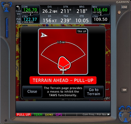
The GTN 750 unit was recovered from the wreckage. It was configured for the aural alerts to be active and the system audio level of alerts was set to 25%. These aural alerts were available through the intercom system to the pilot’s headset.
Additionally, there is a “terrain inhibit” switch on the TAWS annunciator control unit in the pilot’s instrument panel to allow the pilot to silence the aural TAWS alerts as desired. When flying VFR in mountainous terrain, it was not unusual for flight crew to inhibit the alerts because they would sound often and could be distracting. The nature of the impact prevented the investigation from determining the position of this switch before impact.
1.9 Communications
No difficulties were noted with the quality of radio communications during the flight.
1.10 Aerodrome information
Not applicable.
1.11 Flight recorders
The occurrence aircraft was not equipped with a flight data recorder or cockpit voice recorder, nor was it required to be by regulation.
1.11.1 Garmin GPSMAP 296
A hand-held Garmin GPSMAP 296 was recovered from the aircraft and sent to the TSB Engineering Laboratory in Ottawa, Ontario, for download. A total of 337 flights were recovered from the GPS and featured flights going back to June 2019, when the pilot first started flying the occurrence aircraft.
Almost all of the recorded flights featured flight paths that went directly between CYMA and the various remote strips and were completed at altitudes between 7000 and 9000 feet ASL.
The previous flights recorded on the GPS before the day of the accident did not record a flight path along Granite Creek at altitudes below 1000 feet AGL. This was most likely the first day of marginal VFR weather experience in the area, for the pilot as captain on the Grand Caravan.
1.12 Wreckage and impact information
The wreckage was located on a rocky mountain slope on a bearing of 340° true (T), 25 NM from CYMA. The aircraft had impacted a 30–40° rocky slope in a slightly nose-up, wings-level attitude at moderate speed, causing the wings to detach and destroying the aircraft. The wreckage trail was approximately 300 feet long, oriented on a heading of 180° magnetic (M) (Figure 3).
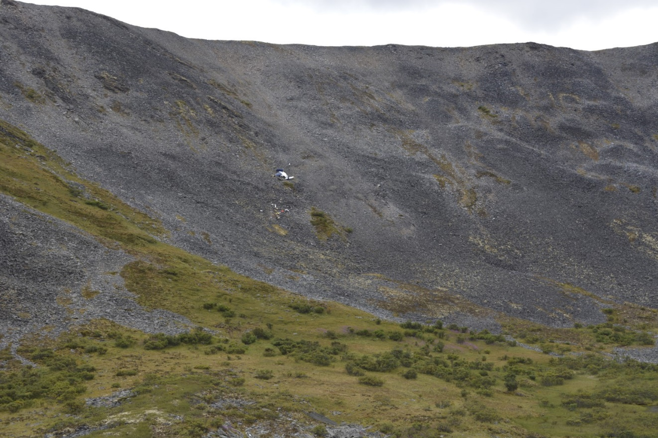
All major aircraft structural components were accounted for during the on-site examination of the wreckage. To the degree possible, continuity of primary flight controls was established. The wing flaps were found in the up position.
1.13 Medical and pathological information
The investigation determined that there was nothing to indicate that the pilot’s performance was degraded by physiological factors.
1.14 Fire
There were signs of a brief post-impact fire on the outboard portion of the left wing.
1.15 Survival aspects
The accident was not survivable due to the impact forces.
Eyewitnesses from the nearby exploration camp were on scene 60 minutes after the accident. Alkan Air dispatched a company aircraft and located the accident site 90 minutes after the accident and a locally based helicopter was on scene with RCMP and emergency medical services at about the same time.
The aircraft was also equipped with a satellite tracking and communications system, which periodically transmits position and speed data back to the base of operations for the company. The company flight-following program uses these data to monitor the flight progress of its aircraft. The system was working; however, it was not used to initially locate the aircraft in this occurrence because the accident site was located by eyewitnesses and the RCMP.
The Canadian Mission Control Centre did not receive a signal from the aircraft’s 406 MHz emergency locator transmitter (ELT).Footnote 6 The transmitter’s antenna cabling was detached during the impact.
The TSB Engineering Laboratory examined the ELT. The unit worked when selected to ON but did not activate via the acceleration of gravity switch (the G switch).
1.16 Tests and research
1.16.1 TSB laboratory reports
The TSB completed the following laboratory report in support of this investigation:
- LP189/2019 – ELT Analysis
1.17 Organizational and management information
1.17.1 Alkan Air Ltd.
Alkan Air Ltd. is an airline headquartered in Whitehorse, Yukon. The company operates both 7-day-a-week charter and air ambulance (MEDEVAC) services. The Whitehorse base and the Mayo base, which is seasonal, generally focus on wheel and floatplane charter and MEDEVAC services in northern and western Canada and Alaska. The Nanaimo, British Columbia, base provides charter and MEDEVAC services focused primarily in western Canada, the western United States, and Mexico. From 2016 to 2018, Alkan Air also operated scheduled flights between Whitehorse/Erik Nielsen International Airport (CYXY), Yukon, and Watson Lake Airport (CYQH), Yukon.
1.17.2 Operational control
Flight operations out of the Mayo base use a Type C operational control system, which delegates operational control to the captain of a flight. The responsibility for the day-to-day conduct of flight operations is retained by the operations manager.
Before each flight for day VFR operations, the captain is responsible for filing a flight plan or flight itinerary with NAV CANADA, or for leaving a flight itinerary with a responsible person. Footnote 7 In this occurrence, only a flight itinerary was created and filed with the company for the flights of the day.
For IFR or night VFR flights, a qualified and knowledgeable person shall be on duty or available; this person is known as a flight follower.Footnote 8 Day VFR flights that originate and terminate on the same calendar day and at the same aerodrome, such as the accident flight, are tracked on the company’s automated flight-following system.Footnote 9
The automated flight-following system consists of satellite tracking technology on the ground and in the aircraft. The system records and transmits the aircraft’s position every 10 minutes and also sends an email to company management when the aircraft takes off or lands, or when the emergency switch on the unit is activated.Footnote 10
When the accident occurred, the automatic flight-following system showed that the aircraft was in flight. and, as a result, the company was not aware of the accident until it was notified by NAV CANADA.
1.17.3 Crew resource management and pilot decision making
The objective of crew resource management (CRM) is to reduce human error in aviation. CRM is widely accepted as an effective use of all human, hardware, and information resources available to the flight crew to ensure safe and efficient flight operations.
For single-pilot operations, the concepts are largely the same. Alkan Air provided training on the general concepts of CRM and pilot decision making for single-crew operations. The pilot completed this self-study course in December 2017.
At the time of the accident, there were no requirements for CRM training for operations under CARs Subpart 703. As of 30 September 2019, Transport Canada requires that an operator provide CRM training to flight crews.Footnote 11,Footnote 12
1.17.4 Controlled flight into terrain training
Transport Canada standards require companies operating under CARs Subpart 703 and conducting IFR or night VFR flights to provide training on the avoidance of CFIT.Footnote 13 This training is to consist of
- factors that may lead to CFIT accidents and incidents;
- operational characteristics, capabilities, and limitations of ground proximity warning systems if applicable;
- CFIT prevention strategies;
- methods of improving situational awareness; and
- escape manoeuvre techniques and profiles applicable to the airplane type.
The Alkan Air training program met this requirement. Although this training was not required for the Caravan operation in CYMA (day VFR flights only), the pilot had last received CFIT awareness training in March 2019.
1.17.5 Flight in reduced visibility in uncontrolled airspace
Alkan Air received Operations Specification 004Footnote 14 from Transport Canada, which authorizes it to conduct day VFR flights in uncontrolled airspace with flight visibility of less than 2 statute miles (SM), to a minimum of 1 SM at altitudes below 1000 feet AGL.
For the Operations Specification to remain valid, the company must comply with the requirements of section 723.28 of the Commercial Air Service Standards (CASS). These include requirements with respect to pilot experience, pilot training programs, and information contained in the company operations manual. Subsection 723.28(2) of the CASS stipulates that, in order for pilots to fly in reduced visibility, they must have accumulated 500 flight hours of experience in CAR Part VII operations in the same category of aircraft (single-engine or multi-engine). The occurrence pilot did not meet the experience requirement. Subsection 723.28(4) of the CASS outlines topics that must be included in the company’s training program. The Alkan Air training manualFootnote 15 complies with these requirements. As required in subsection 723.28(5) of the CASS, the Alkan Air company operations manualFootnote 16 states that C208 aircraft be operated at 90 knots indicated airspeed (KIAS), with flaps set to 20° when operating in reduced visibilities.
Alkan Air made a policy decision to limit the exposure to hazards of the occurrence pilot and another junior Grand Caravan pilot while they were getting to know the aircraft. In a letter issued by the chief pilot on 27 May 2019, these pilots were restricted from flying when the cloud height was below 2000 feet AGL and the visibility was less than 5 SM when operating single-pilot.
1.17.6 Strip-to-strip risk assessment
Alkan Air uses a strip-to-strip pre-flight risk assessment worksheet that it introduced in July 2019 as a trial; these risk assessments were not required by regulation. Following the trial period, the worksheets were to be refined and incorporated into the operations manual as a formal procedure.
The intent of the risk assessment was to engage pilots in assessing the risk on a round-robin trip from their home base to a remote strip and back. The risk assessment worksheet was to be filled out and left behind before the first departure of the day. It was not intended to be used before each departure on a flight with multiple legs.
The worksheet guides the pilot through several operational conditions, such as fuel on board, weather, runway conditions, time of day, familiarity, and crew fitness. These conditions have increasing scores associated with increasing risk levels. A total of the scores will then prompt the pilot into 1 of 3 actions before departing: no consultation, consulting a senior pilot on all risk items scored 3 or higher, or consulting an experienced crew member on all risk areas.
The investigation found several prepopulated risk assessment worksheets for Rau Strip. The prepopulated worksheets, given no additional operational challenges, scored a risk of 13 (Appendix C). Alkan Air did not prepopulate the worksheets when issuing them to flight crews.
The investigation could not find a completed strip-to-strip risk assessment for the flights on the day of the occurrence.
1.18 Additional information
1.18.1 Pilot decision making
Pilot decision making (PDM) is a cognitive process to select a course of action among alternatives, which involves identifying and evaluating options. PDM typically consists of gathering information, processing information, making a decision, acting on that decision, and evaluating the outcome of that decision against what was expected.
After encountering low ceilings and visibilities on the inbound flight to Rau Strip, the pilot had several options to consider before his departure to CYMA:
- obtain more weather information from NAV CANADA or pilot weather reports (PIREPs) from other Alkan Air pilots or company dispatch;
- confer with other Alkan Air pilots on options to consider;
- delay the departure;
- plan an alternate route to CYMA; or
- consider and prepare for entering instrument meteorological conditions (IMC) and completing the flight under IFR as an emergency response to encountering decreasing cloud ceilings and reduced visibilities.
Several factors or biases can, invariably or unconsciously, affect PDM. In flight, PDM occurs in a dynamic environment, and can occur in situations when time is limited.
Pilots operate in a complex environment where there are multiple sources and types of information to monitor. Organizing and simplifying information lessens the burden on their information-processing capacity. Although such information management can aid performance in some conditions, it can sometimes result in strong performancebiases that lead to unsafe decisions, and a reduced probability of recognizing such decisions.
An example of a decision-making bias is the availability heuristic.Footnote 17 This focuses on the timing of an experience, “in that more recent events or conditions in the world generally are recalled more easily.” This means that a pilot may make a decision based on a more recent experience: for example, basing the decision to depart Rau Strip on the success of the previous leg from CYMA to Rau Strip.
Even if an individual makes an initial assumption during a decision, they can always double check the available information to ensure they have considered all facts. Typically, the more uncertain the individual is, the more information they are likely to seek. However, “if one is more confident than is warranted in the correctness of one’s hypothesis, then one will not be likely to seek additional information.”Footnote 18 This is known as the overconfidence bias.
Once a decision has been made, an individual may then bias all subsequent beliefs in favour of that initial decision (anchoring heuristic) and/or actively seek information and cues that confirm that decision, while also discounting those that support an opposite conclusion (confirmation bias).Footnote 19 As a result, “the false hypothesis can be extremely resistant to correction,” especially when expectancy is high and when attention is diverted elsewhere in the flight, for example, to other flight condition threats.Footnote 20 The anchoring heuristic relates to the recency effect observed in working memory. In the presence of complex information, the recency effect will have predominance.Footnote 21
Once a pilot has reached a hypothesis about a certain situation, this will form the basis of their mental model of that situation as they proceed with the flight. Once the decision to proceed with the flight has been made, a pilot may then be at risk of plan continuation bias,which is a form of confirmation bias, a “deep-rooted tendency of individuals to continue their original plan of action even when changing circumstances require a new plan.”Footnote 22 Resistance to changing the plan may be affected by factors such as the perceived loss or gain from changing the plan. ResearchFootnote 23 shows that in flight environments, the framing of a decision in terms of loss or gain of potential outcomes may be affected by the proximity of a pilot’s goals, such as the destination airport. As goal achievement gets closer, there may be a natural shift to the “loss” frame, i.e., changing the plan becomes more negative, resulting in an increased motivation to continue with the original plan.
When focusing on a task, individuals generally seek the most meaningful information needed at that time, fixating on the cues deemed critical, often overlooking other available cues. This is a phenomenon known as perceptual bias.Footnote 24 As workload increases, narrowing or tunnelling of visual and auditory attention may also occur,Footnote 25 exacerbating any perceptual bias.
1.18.2 Flying at low altitude and/or in low visibility
Transport Canada identifiedFootnote 26 that the most critical element in avoiding a collision with terrain in low-altitude flying is time. With more time, a pilot has the ability to:
- identify the obstacle as a hazard;
- select the appropriate action;
- make control inputs; and
- have the aircraft respond.
The 2 elements that will dictate the amount of time available to pilots who are flying at low altitude are ground speed and flight visibility.
In this occurrence, the flight visibility was estimated to have been approximately 1 SM and the aircraft was travelling over the ground at about 156 knots or 264 feet per second. This would give the pilot approximately 20 seconds to understand the aircraft’s position relative to obstacles and the aircraft’s overall position along the route of flight for the purposes of navigation.
At a constant ground speed of 150 knots, an aircraft would need a diameter of 4004 feet to complete a 180° turn at a 45° angle of bank,Footnote 27 and would take 25 seconds to complete the manoeuvre.
At a constant ground speed of 90 knots, an aircraft would need a turn diameter of 1441 feet at 45° angle of bank and 15 seconds to complete the course reversal (Figure 4).

With an estimated weight of 6800 pounds, the atmospheric conditions at the time of the accident, and assuming zero wind, the aircraft would produce a climb gradient to clear the ridge of the box canyon if a cruise climb (115 KIAS, flaps up) was started approximately 2 NM before the accident site.Footnote 28 At the best angle of climb speed (74 KIAS, flaps up) the climb gradient would result in clearing the ridge by starting a climb 1.2 NM before the ridge.Footnote 29
1.18.3 Controlled flight into terrain
CFIT occurs “when an airworthy aircraft under the control of the flight crew is flown unintentionally into terrain, obstacles, or water, usually with no prior awareness by the crew.”Footnote 30
In the early 1990s, CFIT was the primary cause in fatal aircraft accidents worldwide. In the following decades, operators and regulators made strides to reduce accidents of this type. Many new technologies have been introduced, such as TAWS, enhanced ground proximity warning systems, global navigation satellite systems, digital terrain databases, and moving map displays with graphic depiction of the aircraft’s position relative to terrain. Also, improved training is available, such as CFIT awareness training, CFIT escape manoeuvre training, and enhanced CRM with threat error management. When combined, these advances have reduced the number of CFIT accidents, to the point where in-flight loss of control has surpassed CFIT as the primary cause of fatal accidents for aircraft over 5700 kg.Footnote 31
In Canada, there has also been a reduction in CFIT accidents. A TSB statistical review of CFIT accidents in Canada was conducted for the period 1992 to 2019.Footnote 32 The review looked at accidents where Canadian-registered aircraft in commercial flights operating under VFR continued into IMC and a CFIT accident occurred.
In the 28-year period examined, the following accident numbers were noted:
- 60 accidents involved commercial operators (64 fatalities); of those,
- 34 accidents involved airplanes (45 fatalities), and
- 26 accidents involved helicopters (19 fatalities).
A correlation testFootnote 33 was used to determine whether there was any trend in this type of accident over the 28-year period. The accident counts for commercial airplanes showed a decreasing trend over 28 years, while the numbers of accidents involving commercial helicopters did not show statistically significant trends. Most of the overall decrease in accident counts took place during the first 14 years of this period (1992 to 2005), with no trend in the period 2006 to 2019.
2.0 Analysis
2.1 Introduction
The investigation did not find any technical issues with the aircraft that would have contributed to the accident. The analysis will focus on weather, pre-flight risk assessment, pilot decision making, alternatives when encountering low visibility in mountainous terrain, navigation, and the terrain awareness and warning system (TAWS).
2.2 Weather
The weather encountered during the late morning on 06 August 2019 was consistent with the forecast for the area. The pilot encountered low clouds and visibilities in precipitation from the scattered convective weather on the flight from Mayo Airport (CYMA), Yukon, to Rau Strip, Yukon, and on the return flight.
The pilot was not allowed to fly if the visibility was less than 5 statute miles (SM) and the cloud height was below 2000 feet above ground level (AGL). The hourly weather and forecast weather in Mayo never went below the weather restrictions placed on the pilot; however, the weather encountered along the route from CYMA to Rau Strip was less than those restrictions.
2.3 Pre-flight risk assessment
Alkan Air began a program a few weeks before the accident that required pilots to perform a risk assessment before each takeoff from CYMA to the various remote strips to which they fly.
The investigation found several prepopulated risk assessment worksheets for Rau Strip. Since these had already been completed, pilots may not have always been going through the worksheets as intended. The investigation could not determine the purpose of the prepopulated worksheets; however, they may have resulted in pilots not conducting a step-by-step review of the hazards before departures from CYMA.
Although this risk assessment tool has the potential to be an effective safety defence, its use had not matured at the time of the occurrence because it had been introduced only several weeks prior. Using a prepopulated worksheet would likely decrease the effectiveness of an assessment. If administrative safety defences are not used as intended, it increases the risk that the hazards associated with the flight will not be identified and mitigated.
2.4 Pilot decision making
This was the pilot’s 1st assignment as a captain at Alkan Air in a challenging operational environment: single-pilot visual flight rules (VFR) operations in mountainous terrain flying to remoteunprepared strips. The pilot’s above-average performance during training and the company’s confidence in the pilot to perform this type of flying suggests that he had a significant level of confidence and optimism.
The company recognized the hazards associated with these types of operations and provided training that exceeded what was required by regulation to ensure that the pilot was competent for the operation. In addition, weather restrictions were placed on the pilot to ensure that he did not get into a situation where weather would be problematic.
The decision to depart Rau Strip to CYMA was influenced by several factors. Because the pilot had recently completed the flight from CYMA to Rau Strip, his decision making would have been affected by his familiarity with the route and, consequently, he likely did not consider an alternate route or discuss it with senior pilots. Once airborne en route to CYMA, plan continuation bias and confidence would have further affected his decision making with respect to taking action in altering his route when confronted, once again, with the low visibilities and cloud ceilings.
Once the pilot entered Granite Creek and began to fly even closer to the tree tops, his cognitive workload would have increased significantly. As the pilot became task saturated, a narrowing of visual and auditory attention occurred. This perceptual bias would have taken effect as the pilot focused on the task of flying. This likely resulted in the pilot choosing the most meaningful information by fixating on the cues deemed critical and perhaps overlooking other available cues, which could have prompted actions, such as reducing aircraft speed, selecting an escape route, and interpreting his location accurately.
The pilot’s decision making was influenced by several biases and, as a result, the flight departed and subsequently continued into poor weather conditions in mountainous terrain.
2.5 Alternatives when encountering low visibility in mountainous terrain
The pilot was trained to fly the aircraft in instrument meteorological conditions (IMC) and the aircraft was equipped to do so. Encountering low clouds and reduced visibility in a VFR operation in mountainous terrain can be considered an emergency. One option available to pilots is to climb into cloud to a safe altitude.
In this occurrence, the pilot held a valid instrument rating and the aircraft was equipped to fly in IMC. However, there was no record of the pilot transitioning from VFR to a flight under instrument flight rules (IFR) in an emergency in his flying history on the Cessna 208B Grand Caravan or in his training.
2.6 Navigation
Shortly after departure from Rau Strip, the pilot began encountering cloud ceilings, which required him to fly, at times, as low as 100 to 200 feet above terrain and in visibilities that were likely as low as 1 SM. The global positioning system (GPS) track data showed that the aircraft remained at the cruise airspeed of 156 knots. At no time did the pilot configure the aircraft for operations in reduced visibility by setting the flaps to 20° and reducing the airspeed to 90 knots indicated airspeed, as indicated in company procedures. The high speed at low altitude and low forward visibility reduced the opportunities for the pilot to take alternative action to avoid terrain.
When flying at low altitude, pilots direct a significant portion of their attention outside the aircraft to avoid striking trees. This was likely the case in this occurrence just before the aircraft turned south into the box canyon, where it was observed at near treetop level.
In addition, when pilots direct their attention outside the aircraft, it reduces their ability to refer to paper maps and to the moving map display. Therefore, their primary awareness of the aircraft’s location is based on their recollection of their last known position, especially when they are in a valley or canyon. This recollection can also be compromised when flying at a lower altitude than the pilot is used to and in reduced visibility.
The previous flights recorded on the GPS did not include the occurrence route at this altitude. Therefore, this was most likely the pilot’s first experience, as captain in the Grand Caravan, in significantly reduced visibility and low altitude flying in the area.
The pilot turned into the box canyon likely believing that it was the continuation of Granite Creek as it turned to the south, toward the west end of Mayo Lake. The GPS did not record a change of altitude that would suggest the pilot was trying to perform a best angle of climb manoeuvre (also known as a maximum gradient climb manoeuvre) to clear the ridge of the box canyon. Instead, there was a slight increase in altitude that followed the initial gradual elevation terrain in the box canyon.
Within the box canyon, the canyon floor elevation increased abruptly within less than 1 NM and the low visibility prevented the pilot from detecting this and taking sufficient actions to prevent collision with terrain.
2.7 Terrain awareness and warning system
The Garmin GTN 750 installed in the occurrence aircraft featured Class B TAWS software that could warn a pilot of terrain that may come into conflict with the current flight path. These alert features were designed for situations where most of the flight would be well above terrain.
When flying in mountainous terrain at low level, the terrain cautions and warnings are near-continuous. As a result, the aircraft is equipped with a “terrain inhibit” switch that can silence the aural alerts. In this occurrence, the TAWS-B would have been providing alerts to the pilot during significant portions of the occurrence flight. To prevent distraction from these aural alerts, the pilot may have silenced them.
When the pilot turned into the box canyon, the TAWS-B aural alerts were ineffective in warning the pilot about the rising terrain either because he had already heard multiple similar alerts in the preceding minutes, or because he had silenced the alerts.
3.0 Findings
3.1 Findings as to causes and contributing factors
These are conditions, acts or safety deficiencies that were found to have caused or contributed to this occurrence.
- The pilot’s decision making was influenced by several biases and, as a result, the flight departed and subsequently continued into poor weather conditions in mountainous terrain.
- The high speed at low altitude and low forward visibility reduced the opportunities for the pilot to take alternative action to avoid terrain.
- Within the box canyon, the canyon floor elevation increased abruptly within less than 1 NM and the low visibility prevented the pilot from detecting this and taking sufficient actions to prevent collision with terrain.
- When the pilot turned into the box canyon, the terrain awareness and warning system aural alerts were ineffective in warning the pilot about the rising terrain either because he had already heard multiple similar alerts in the preceding minutes, or because he had silenced the alerts.
3.2 Findings as to risk
These are conditions, unsafe acts, or safety deficiencies that were found not to be a factor in this occurrence but could have adverse consequences in future occurrences.
- If administrative safety defences are not used as intended, it increases the risk that the hazards associated with the flight will not be identified and mitigated.
3.3 Other findings
These items could enhance safety, resolve an issue of controversy, or provide a data point for future safety studies.
- The pilot held a valid instrument rating and the aircraft was equipped to fly in instrument meteorological conditions. However, there were no scenarios in the pilot’s flying history on the Cessna 208B Grand Caravan or in his training where a transition from visual flight rules to a flight under instrument flight rules in an emergency was performed.
4.0 Safety action
4.1 Safety action taken
4.1.1 Alkan Air Ltd.
The following actions have been taken by Alkan Air since the accident:
- Flight-following procedures have been updated to ensure that, when passenger manifests are changed, flight crew notify flight following.
- The Alkan Air Emergency Response Plan has been modified such that, if a third party inquires about a possible missing or crashed aircraft, the company will assume it is one of its aircraft until it confirms it is not.
- The Alkan Air Emergency Response Plan has been updated to include changes to enhance communication between members of the response team and to ensure that any Alkan Air aircraft that are used for searching are dispatched with 2 flight crew members.
- Clarification with all flight crew that a NAV CANADA flight plan must be filed for all flights. The company indoctrination program has also been modified to make this clear to new hires.
- All Cessna 208B Grand Caravan captains (less than 2000 flight hours total time) will require a second flight crew member on the aircraft.
- The training program for Cessna 208B Grand Caravan aircraft has been amended to include low-level route training for new captains.
- Before becoming a captain on the the Cessna 208B Grand Caravan, candidates must perform as a second crew member on this type of aircraft for 1 season.
- The flight crew assigned to the Mayo base of operations will be rotated out on a more frequent basis.
This report concludes the Transportation Safety Board of Canada’s investigation into this occurrence. The Board authorized the release of this report on . It was officially released on .
Appendices
Appendix A – Flight path data

Source: Google Earth, with TSB annotations
Appendix B – Profile view of accident flight showing GPS altitude (red line) compared to Google Earth terrain elevation
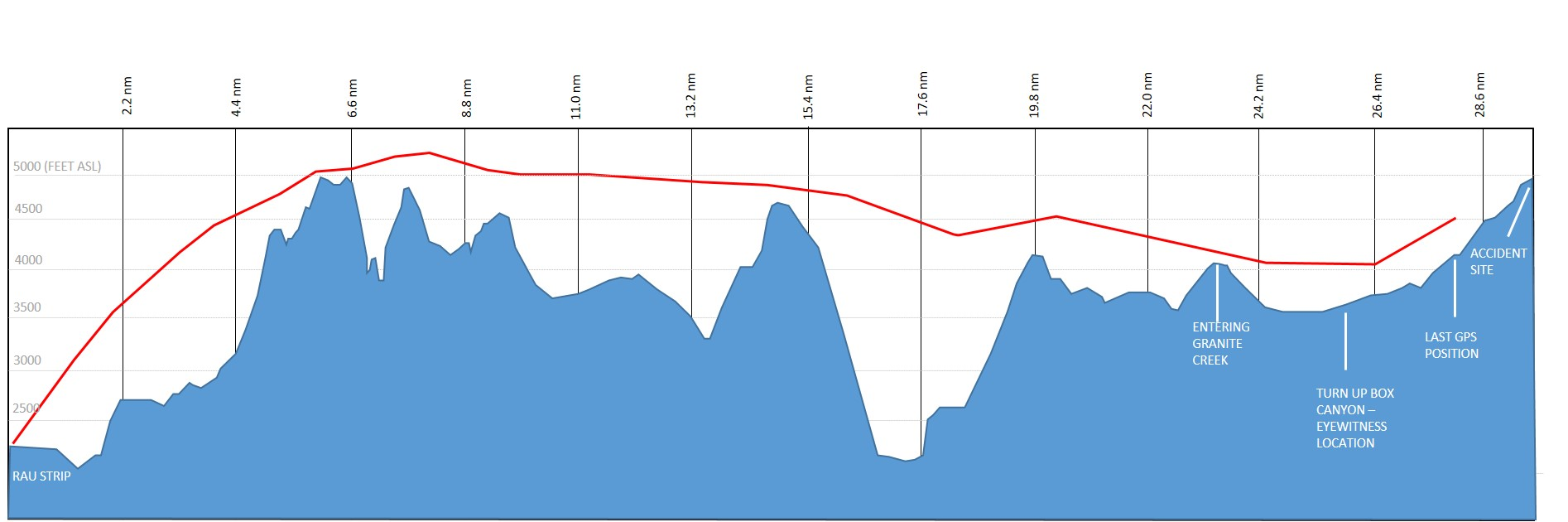
Source: Google Earth, with TSB annotations
Appendix C – The pre-populated strip-to-strip operations pre-flight risk assessment for flights between Mayo Airport and Rau Strip
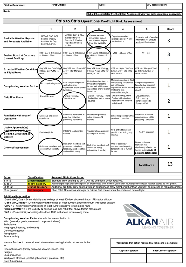
Source: Alkan Air Ltd., with TSB annotations