Collision with trees
de Havilland DHC-2 Mk.1 (Beaver), C-GRHF (private)
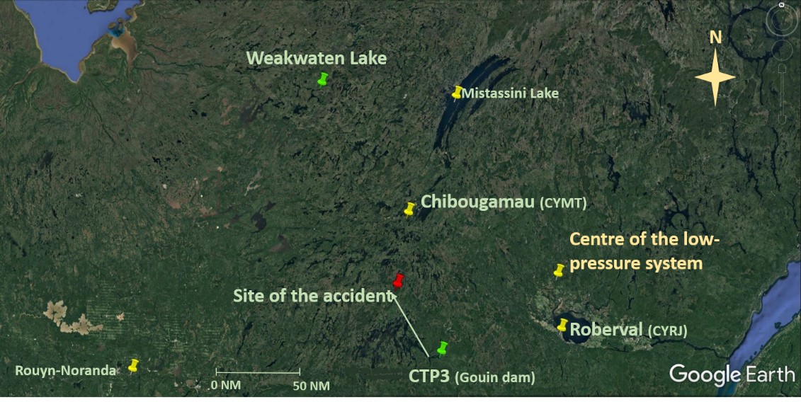
Chibougamau, Quebec, 43 NM S
The Transportation Safety Board of Canada (TSB) investigated this occurrence for the purpose of advancing transportation safety. It is not the function of the Board to assign fault or determine civil or criminal liability. This report is not created for use in the context of legal, disciplinary or other proceedings. See Ownership and use of content. Masculine pronouns and position titles may be used to signify all genders to comply with the Canadian Transportation Accident Investigation and Safety Board Act (S.C. 1989, c. 3).
History of the flight
At approximately 1000Footnote 1 on 12 July 2019, a private de Havilland DHC-2 Mk. 1 Beaver floatplane (registration C‑GRHF, serial number 1123) took off from the St-Mathias Water Aerodrome (CSV9), Quebec, with only the pilot on board, for a series of visual flight rules (VFR) flights. The aircraft landed at approximately 1130 on Désert Lake in La Minerve, Quebec, and came alongside a private dock where 3 individuals were waiting to board and fly to a fishing lodge.
Once the baggage was stowed on the aircraft, the pilot provided a safety briefing to the passengers, who were all wearing a personal flotation device. The aircraft took off from Désert Lake at approximately 1215, bound for the Barrage Gouin Water Aerodrome (CTP3), Quebec, where the aircraft was scheduled to be refuelled. The aircraft landed at approximately 1430. Once the refuelling was complete, the aircraft took off once again around 1528, headed northwest to Weakwaten Lake, Quebec, where the fishing lodge was located.
After approximately 48 minutes of flight, at around 1616, the aircraft collided with trees and struck the ground. There was no post-impact fire. The emergency locator transmitter was activated by the force of impact, and began transmitting a signal on frequency 121.5 MHz. This signal was detected by the flight crew of a commercial airliner at 1705 and reported to air traffic services. At 1850, the Joint Rescue Coordination Centre in Trenton dispatched a CC130 Hercules aircraft to try to locate the distress signal. The occurrence aircraft was found in a densely wooded area at 2032. Two search and rescue technicians were parachuted to rescue the aircraft occupants. Three of the 4 occupants received fatal injuries. The survivor was evacuated and transported to the hospital in Chibougamau, Quebec.
Weather information
For the purposes of this investigation, the TSB asked the Meteorological Service of Canada’s Prediction Services Directorate to prepare a weather analysisFootnote 2 of the weather conditions on 12 July.
At 1300, the centre of a quasi-stationary low-pressure system was located approximately 37 statute miles (SM) north of the Roberval Airport (CYRJ), Quebec (Figure 1). Areas to the west and northwest of the low-pressure system were influenced by a cloudy return flow strengthened by high humidity, which was 87% at CTP3 and 100% near the site of the accident. Localized areas of mist, drizzle or intermittent rain were also possible in these areas, which could lead to a reduction in visibility and in the height of the cloud ceiling. Between 1300 and 1700, the Chibougamau/Chapais Airport (CYMT), Quebec, located approximately 43 nautical miles (NM) north of the scene of the accident, reported visibility varying between 2½ SM and 9 SM, with a ceiling at 400 feet above ground level (AGL) and intermittent low precipitation.Footnote 3
Between 1300 and 1700, the cloud base was generally between 400 and 1200 feet AGL in the areas to the west and northwest of the low-pressure system. Given that the elevation at the site of the accident was higher than that of the weather stationsFootnote 4 providing the data, it is possible that the cloud ceiling was below 400 feet AGL in some places.
The temperature recorded to the north of the Gouin Reservoir was approximately 14 °C. According to the weather analysis, the aircraft did not encounter any icing conditions while in flight. Furthermore, low level winds were light, and no wind shears or turbulence were forecast below 4500 feet above sea level (ASL).
Pilot information
The pilot held a private pilot licence – aeroplane, with ratings to operate single-engine aircraft and seaplanes, and conduct night flights. He had a valid Category 3 medical certificate. The pilot had accumulated 1028 hours of flight time in total, including 314 hours on board the DHC-2 Beaver.
The pilot had taken training to meet the recency requirement stated in paragraph 401.05(2)(a) of the Canadian Aviation Regulations (CARs). According to the pilot’s documents, his last theoretical training was on 4 February 2017. The pilot’s personal log indicated that the last flight to meet the recency requirement was on 21 May 2018, with no specifics as to the type of flight training conducted.
The pilot had executed 5 takeoffs and 5 water landings in the 6 months preceding the flight in accordance with the regulatory requirementFootnote 5 regarding the transportation of passengers.
The pilot was certified and qualified for the flight in accordance with existing regulations.
There was no indication that the pilot’s performance was degraded by physiological factors.
Aircraft information
The occurrence aircraft was built in 1957 by de Havilland Aircraft of Canada Ltd. It was powered by a Pratt & Whitney, 9-cylinder, radial, air-cooled engine which drove a Hamilton Standard constant-speed propeller. The aircraft was equipped with floats. At the time of the occurrence, it had accumulated 15 040.5 flight hours and approximately 7 hours since the last annual inspection, which included a 500-hours maintenance inspection. Technical records indicate that the aircraft was certified, equipped and maintained in accordance with existing regulations. There was no evidence of an airframe, engine or system failure during the occurrence flight.
The aircraft was equipped with 12 vortex generators and 2 leading edge “delta winglets” mounted on each wing, which had been installed in accordance with Supplemental Type Certificate (STC) SA96-126 issued by Transport Canada (TC) to Aeronautical Testing Service Inc. According to the STC holder, the vortex generators can be used to enhance aircraft performance: reducing the stall speed, improving stability and increasing the take-off weight.Footnote 6 However, the STC did not require a supplement to the existing flight manual, implying amongst other things that the maximum take-off weight would remain the same as that specified in the DHC-2 flight manual, in other words, 5090 pounds when the aircraft is equipped with floats.
The maximum permissible take-off weight indicated in the current amendment of the weight and balance report was 5370 pounds. The aircraft would therefore likely have been modified in accordance with an STC in order to be able to increase its maximum permissible take-off weight. According to the information gathered during the investigation, it could have been STC SA98-10, issued on 14 January 1998 by TC to Kenmore Air Harbour Inc. The purpose of this STC was to increase the maximum permissible take-off weight to 5370 pounds, and required structural modifications.
The technical records availableFootnote 7 and the documentation obtained from TC did not contain any mention of this STC.
Furthermore, an examination of the wreckage revealed that some of these structural modifications had not been done. In the absence of reliable technical documentation, the investigation was unable to determine whether STC SA98-10 had been incorporated. Moreover, no other STC designed to increase the maximum permissible take-off weight of the occurrence aircraft was found. Consequently, there was no evidence showing that the maximum permissible take-off weight could be more than 5090 pounds, even though the pilot and the approved maintenance organization that maintained the aircraft were convinced that STC SA98-10 had been incorporated.
Planning the cross-country flight
Determination of the aircraft’s weight
The trip had initially been scheduled for 11 July. When the trip was being planned, approximately 10 days before departure, a stop at Ledden Lake, next to CYMT, had been included for refuelling purposes. The aircraft’s weight had been calculated, taking into account the baggage and passenger weights provided to the pilot on request. The fuel weight had been determined based on the remaining weightFootnote 8 available to achieve the maximum permissible take-off weight of 5370 pounds, as indicated in the current amendment of the aircraft’s weight and balance report. However, the investigation was unable to determine how the fuel planned for the flights was distributed among the aircraft’s tanks and the six 20 L canisters stowed in the float compartments.
Pre-departure weather checks
The flight on 11 July was delayed until 12 July due to poor weather conditions. At 0904 on the morning of 12 July, the pilot contacted the Québec flight service station (FSS) to obtain a weather forecast. The briefing indicated a low cloud cover due to a humid and unstable air mass associated with the low-pressure system. According to the forecast, the cloud base was going to rise during the morning, in time for the flight to La Minerve. However, as the aircraft got closer to the low-pressure system, the cloud cover density would increase; the ceiling could drop to 800 feet and visibility could be reduced to 2 SM in places due to isolated showers.
The pilot contacted the Québec FSS 2 more times to track the changing weather conditions. Although no improvements were expected, the decision to conduct the flight was upheld, with an intention to reassess the situation while en route. A flight itinerary was filed with a responsible person and the flight was tracked using the pilot’s SPOTFootnote 9 satellite personal tracker, brought on board.
Given that the cloud ceiling was low at CYMT, the pilot decided to refuel at CTP3, which extended the distance to the lodge by approximately 85 NM compared with the initial plan.
Refuelling on departure from CTP3
At CTP3, all of the aircraft’s tanks were filled, along with the 6 canisters, which added approximately 300 pounds to the total weight of 5370 pounds initially calculated by the pilot. The investigation was unable to determine whether the pilot knowingly accepted this excess weight. The total weight of the aircraft on takeoff from CTP3 was estimated by the TSB to be 5810 pounds. Based on the list provided to the pilot by the passengers, the weight of the baggage, food and drinks may have been underestimated. Also, some of the items brought on board did not appear on the list provided to the pilot.
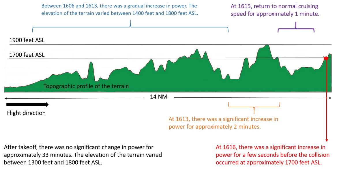
After approximately 48 minutesFootnote 10 of fuel use, the aircraft’s weight at the time of the accident was estimated to be 5685 pounds, which is 315 pounds over the maximum permissible take-off weight used by the pilot during flight planning, or 595 pounds over the maximum weight specified in the DHC-2 flight manual when the aircraft is equipped with floats.
Review of flight route
The aircraft took off from CTP3 at approximately 1528 heading northwest. The pilot was using the ForeFlight application, installed on a tablet, as a navigation aid. No flight data could be retrieved from the tablet by the specialists at the TSB Engineering Laboratory. However, data were successfully downloaded from the engine data management system that was installed on board the aircraft, which helped to establish that the engine was working properly.
The pilot’s SPOT tracker transmitted a signal at 1547 between CTP3 and the accident site, providing the aircraft’s global positioning system (GPS) location at that time. According to the data collected during the investigation, the flight path between CTP3 and the accident site seems to have been flown primarily in a straight line. In addition, the time at which the SPOT tracker’s signal was transmitted helped to determine the aircraft’s various ground speeds between CTP3 and the accident site, and to determine that the aircraft had slowed down before the accident.
Using the aircraft’s estimated straight path and comparing the data from the engine data recording and monitoring system, the estimated ground speeds and the topography, a correlation was found between the use of the power lever and the topography of the terrain (Figure 2). It was also found that the aircraft’s altitude in relation to the terrain lessened as the flight progressed.
View from the cockpit
Deteriorating weather conditions can force a pilot flying under VFR to reduce altitude to avoid losing all visual contact with the surface. Given that a pilot will tend to reduce speed as the aircraft approaches the ground, the aircraft could end up in slow flight.Footnote 11
In slow flight, the aircraft is more nose-up than it is at cruising speed. The nose-up position changes the position of the horizon visible from the cockpit as well as the earth’s surface that is visible (Figure 3). The horizon and the earth’s surface are therefore the main visual cues used by a pilot to determine the aircraft’s attitude. If a pilot sees the horizon move to the lower part of the windshield and the earth’s surface that is visible diminish above the instrument panel, the pilot can recognize the aircraft’s nose-up position.
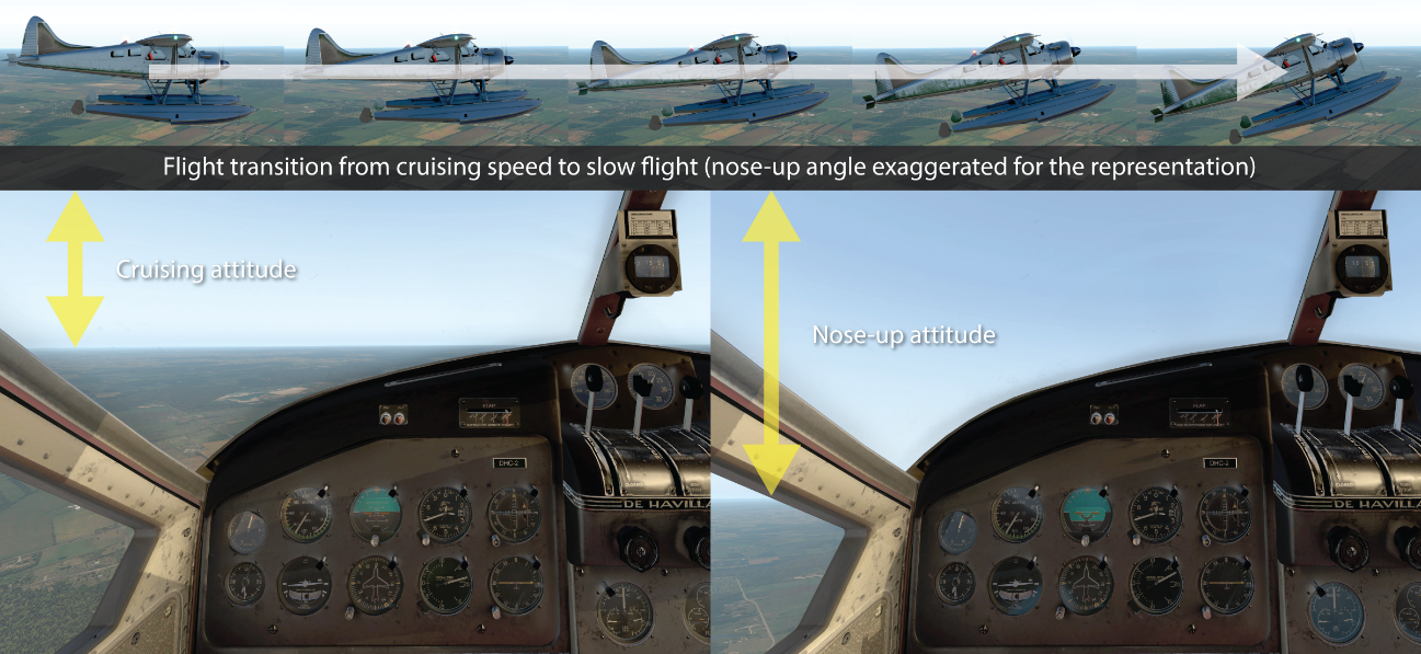
In mountainous terrain, given that the rising terrain often masks all references to the actual horizon, the pilot will have a harder time accurately assessing the aircraft’s attitude and altitude if the pilot relies solely on the visual cues without referring to the flight instruments. For example, an incorrect reference to the horizon can create the illusion that the aircraft is in level flight when it is actually descending.
![Pilot’s viewing angle depending on the flight attitude (Source: TSB, using figures in Transport Canada’s Air Command Weather Manual [TP 9352E] and Flight Training Manual [TP 1102E])](/sites/default/files/eng/rapports-reports/aviation/2019/a19q0107/images/a19q0107-figure-04.png)
In slow flight, the pilot’s front viewing angle is reduced (Figure 4). Also, when the aircraft has a high instrument panel, as is the case in the DHC-2, the reference line for the actual horizon and the terrain may be completely hidden by the instrument panel. Hence, the visual cues needed to detect obstacles straight ahead are greatly reduced, which hinders the pilot’s ability to maintain a safe altitude when flying at low altitude, and even more so when visibility is reduced.
In this occurrence, the fact that there was a sudden increase in power a few seconds before the collision with the trees, while the aircraft was possibly descending toward a rising terrain, suggests that the pilot saw the trees too late. The reduced speed, excess weight and proximity of the trees prevented the aircraft from regaining sufficient altitude to avoid the impact.
Safety messages
Effective pre-flight planning contributes to mitigating the risks associated with unforeseen circumstances and to deciding in advance on a backup plan, if necessary. Sometimes, however, information that is missing, incorrect or not reassessed according to the circumstances creates an unsafe situation of which the pilot is unaware, as was the case for the excess weight in the occurrence aircraft.
A flight conducted in a remote area where detailed weather data and fuel are not readily available has additional risks. To minimize these risks, pilots must set clear limits for themselves or their passengers in advance, limits that should provide a margin of safety for the flight and assist pilots in knowing when to implement their backup plan before the margin of safety disappears.
Adverse weather conditions, such as a low cloud ceiling and reduced visibility, may compel a pilot to decrease the flight altitude to maintain visual contact with the ground. When a flight is conducted in a mountainous area at very low altitude, the pilot is quite likely to reduce speed, which will affect the aircraft’s attitude. Given that visibility from the cockpit is reduced, the risk of collision with terrain or an obstacle in front of the aircraft will be greater if altitude is insufficient.
This report concludes the Transportation Safety Board of Canada’s investigation into this occurrence. The Board authorized the release of this report on . It was officially released on .