
Marine transportation safety investigation report M22C0338
Bottom contact
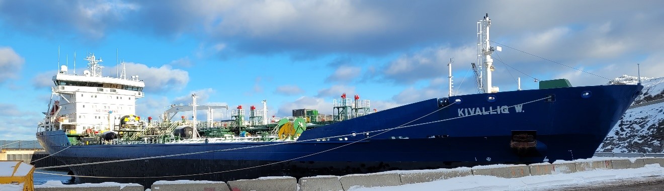
Oil and chemical tanker Kivalliq W.
Chesterfield Narrows
Baker Lake, Nunavut
The Transportation Safety Board of Canada (TSB) investigated this occurrence for the purpose of advancing transportation safety. It is not the function of the Board to assign fault or determine civil or criminal liability. This report is not created for use in the context of legal, disciplinary or other proceedings. See Ownership and use of content.
Description of the vessel
The Kivalliq W. (International Maritime Organization [IMO] no. 9187409) (Figure 1) is a double-hulled oil and chemical tanker of steel construction owned by Coastal Shipping Limited. The vessel’s ice class is type A.Footnote 1 Propulsion is provided by a single diesel engine. The vessel has a single controllable-pitch propeller, a single rudder, and a bow thruster. The vessel’s maximum draft is 8.45 m. The Kivalliq W. has a maximum speed of 15.5 knots, and a service speed of 14.5 knots.
The bridge is equipped with all navigational equipment required by regulations, including a simplified voyage data recorder (S-VDR).
At the time of the occurrence, as required by the International Convention on the Safety of Life at Sea (SOLAS Convention), the vessel had a valid safety management certificate that was issued by DNV in 2021. The bridge watch officers operated on a 6 hours on, 6 hours off watch schedule, and the crew complement and watch schedule were compliant with the safe manning document issued by Transport Canada.
Coastal Shipping Limited had been contracted to deliver liquid bulk cargo to Baker Lake, Nunavut, for the 3 years prior to the occurrence. The Kivalliq W. made multiple voyages along the occurrence route throughout the year of the occurrence, including a passage 3 days before the bottom contact.
History of the voyage
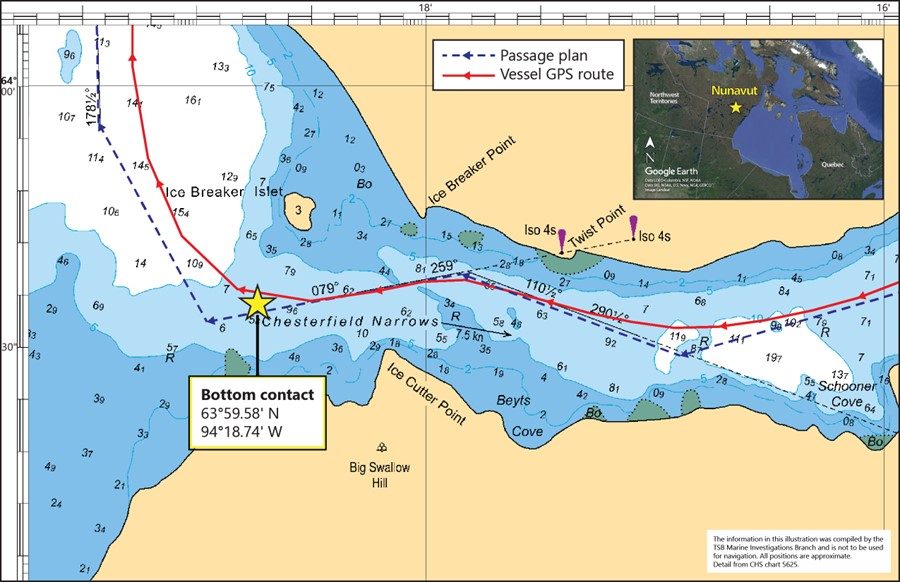
At 0230Footnote 2 on 18 October 2022, the Kivalliq W. completed a ship-to-ship transfer operation with the Marlin Ametrine at the anchorage off Helicopter Island, Nunavut, and then proceeded toward Baker Lake, with the intention of arriving at Chesterfield Narrows for slack water 2 hours after high tide. On this day, high tide was predicted for 0232 at a height of 1.7 m. The vessel’s draft at departure was 4.8 m on an even keel. According to the passage plan, the vessel was expected to maintain an under-keel clearanceFootnote 3 in excess of 1 m throughout its transit of Chesterfield Narrows.
At 0424, the master took over navigation of the vessel from the officer of the watch. The vessel remained on manual steering, and the speed was adjusted to 5 knots. The engine room crew was ordered to stand by, and a security call was broadcast on VHF channel 16 to inform any traffic in the area of the vessel’s presence and intention to proceed westward in the narrows.
At approximately 0450, as the vessel turned to exit Chesterfield Narrows (Figure 2), an abnormal vibration was felt throughout the vessel, and the vessel was slower to respond to helm orders. Shortly thereafter, the master sent the officer of the watch to the cargo control room to check the instruments for possible water ingress, and initiated emergency procedures. It was suspected that the vessel had made bottom contact with an uncharted submerged object. The master directed the vessel toward a nearby anchorage and ordered the crew to assemble at the muster stations.
At approximately 0458, the deck crew began manually sounding the ballast water tanks to check for water ingress.
As the vessel listed to starboard, water was found in the No. 3 starboard ballast water tank. Before the occurrence voyage, this tank was empty; the presence of water in the tank confirmed to the crew that the vessel had made bottom contact and that the hull had been breached. All other tanks appeared intact, including those in the engine room spaces.
After communicating with Transport Canada Marine Safety and Security, the vessel was authorized to continue its voyage to Baker Lake, where further inspections were carried out. Additionally, at the request of the TSB, the S-VDR data for the occurrence were saved.Footnote 4 After inspection by DNV, the vessel was allowed to proceed on its own power to the dry dock in Les Méchins, Quebec, for repairs.
On 01 November 2022, the Kivalliq W. departed Baker Lake for Les Méchins and was accompanied by a Canadian Coast Guard (CCG) icebreaker until it left Arctic waters. The vessel arrived at its destination on 09 November 2022.
Environmental conditions
At the time of the occurrence, the air temperature was 0 °C, the skies were clear with a visibility of 8 nautical miles, the wind was from the south-southeast at 20 knots, and the sea was calm. The tide was ebbing; high tide occurred at 0232 (1.7 m) and was due to be low at 0901 (0.6 m). No ice was sighted by the crew, and the ice charts did not indicate the presence of ice at the time.
Damage to the vessel
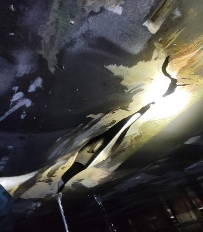
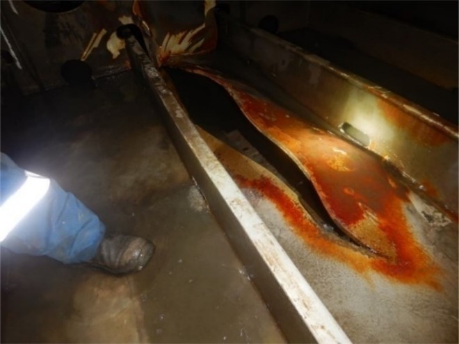
As a result of bottom contact, the Kivalliq W. sustained a hull breach below the waterline. The damage was limited to the bottom shell plating of the No. 3 starboard ballast water tank, between frames 105 and 108. The breach, which caused the ingress of water, was approximately 3 m in length (figures 3 and 4).
Personnel experience and certification
At the time of the occurrence, the bridge team was composed of the master, the second officer, and a wheelsman, all of whom held valid certification in accordance with applicable regulations.
Role and mandate of the Canadian Hydrographic Service
According to the Oceans Act,Footnote 5 the Minister of Fisheries, Oceans and the Canadian Coast Guard is responsible for the Government of Canada’s policies and programs regarding oceans. Among other responsibilities, the Minister provides hydrographic services to promote safe marine navigation and facilitate maritime trade and commerce. Through the Canadian Hydrographic Service (CHS), the Minister may conduct hydrographic and oceanographic surveys of Canadian and other waters, and prepare and publish data, reports, statistics, charts, maps, plans, and other documents.
According to the Navigation Safety Regulations, 2020,Footnote 6 vessels must carry up-to-date charts and other nautical publications, made by or under the authority of the CHS, necessary for their intended voyage.
The CHS is also responsible for ensuring that Canada fulfills certain international obligations. The SOLAS Convention requires contracting states such as Canada to provide hydrographic services adequate for the needs of safe navigation as well as adequate, up-to-date charts and publications for all vessels.Footnote 7 The CHS is also responsible for producing charts or publicizing the coordinates for Canada’s maritime boundaries, as required under the United Nations Convention on the Law of the Sea. Finally, through Transport Canada, the CHS supports the work conducted at the IMO to establish carriage requirements for electronic chart display information systems.
The CHS delivers its services by performing targeted hydrographic surveys, which provide data to map the seafloor, and communicating this information to mariners via electronic and paper navigational charts. These authoritative products are maintained and updated with new information on a continual basis via Notices to Mariners (NOTMAR).Footnote 8 The CHS also operates a network of tide gauges, which provide real-time measurements of sea or lake levels, and inform tide tables.
Data quality and survey standards
The CHS does not have dedicated vessels for data collection in the Canadian Arctic; rather, it relies primarily on CCG vessels for its surveys. The CHS also accesses ship time for dedicated surveys in addition to collecting data opportunistically while CCG vessels are on standby for ice escort or while transiting. CHS also procures services through private industry, other vessels of opportunity,Footnote 9 and other various trusted sources.
The remoteness, harsh meteorological conditions, seasonal and permanent sea ice coverages, and low marine traffic in Canadian Arctic waters are factors that impact the quality of hydrographic data collected, some of which are decades old. As of October 2022, 15.8% of Canada’s Arctic waters had been surveyed to modern or adequate standards. This includes approximately 44.7%Footnote 10 of the high traffic areas determined through the Northern Low-Impact Shipping Corridors initiative.Footnote 11
Chesterfield Narrows
CHS Chart 5625 – Schooner Harbour to Baker Lake covers the Chesterfield Narrows and surrounding waters. Three editions of this chart have been released: the first in 1975 and the second in 1992. Both of these editions used the hydrographic survey done in 1974 with soundings spaced 100 m apart. A chart correction was published in 2004 in a Notice to Mariners,Footnote 12 for the area of the occurrence; this correction added depth data from a survey in 1997. The most recent edition was published in 2018 based on a hydrographic survey done in 2016.
In 2016, IIC Technologies Inc. was contracted by the CHS to carry out a bathymetric survey of the area between Baker Lake and the Chesterfield Narrows. This project included the installation of temporary tidal gauges and a multi-beam survey. The survey was conducted between 19 July and 20 September 2016. The data collected from this survey were used to update Chart 5625. The zone of confidence indicated on the electronic chart is A1,Footnote 13 which is the highest modern standard for hydrographic surveys.
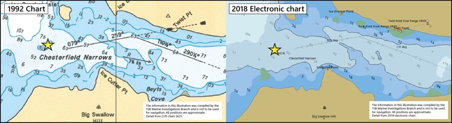
The 1992 edition of Chart 5625 shows a depth of 4.2 m at the occurrence position (Figure 5). The 2018 edition of the chart, which was used in this occurrence, does not show the same shallow depth at this position. Six years elapsed between the hydrographic survey used for the 2018 edition of the chart and the occurrence involving the Kivalliq W.
The Canadian Sailing Directions for Northern Canada (ARC 400)Footnote 14 warn that nautical charts represent the general conditions present at the time of the hydrographic survey, and that the survey may fail to find every obstruction in areas with rocks. In such waters, customary routes and channels should be followed. The seafloor of the occurrence area is mainly composed of rocks.
No permanent tidal gauges are installed in the Chesterfield Narrows, so tidal information is obtained by calculations that are informed in part by a tidal survey conducted in 2016. The Canadian Tide and Current Tables for the Arctic do not provide a margin of error for seafarers to consider when determining the deepest draft at which their vessel can maintain a safe under-keel clearance.Footnote 15 The Kivalliq W.’s passage plan was carried out with the expectation that the vessel would have a minimum under-keel clearance of 1.77 m at the occurrence location.
Safety action taken
The crew of the Kivalliq W. reported the uncharted submerged object to Marine Communications and Traffic Services in Iqaluit, Nunavut, and a navigational warning was published the day of the occurrence.Footnote 16 Ten days later, after the CHS reviewed the data provided by the vessel, a second navigational warningFootnote 17 was published.
Following the occurrence, the CHS reviewed the data collected from the 2016 hydrographic survey, and on 31 March 2023, the CHS published a chart correction to indicate depths of 5.1 m in the area of the occurrence.Footnote 18 This cancelled the second navigational warning.
The first navigational warning will remain in effect until a hydrographic survey is carried out.
Safety messages
Seafarers navigating in Canadian Arctic waters should be aware that nautical charts represent the general conditions present at the time of the hydrographic survey and may not reflect the actual condition of the seafloor. Even if an area is charted and surveyed to modern hydrographic standards, crews navigating within those waters must exercise extra caution with due regard to under-keel clearance.
Seafarers navigating in areas where tide prediction calculations are used to determine under-keel clearance should be aware that water levels are predicted, and a margin of error should be taken into account.
This report concludes the Transportation Safety Board of Canada’s investigation into this occurrence. The Board authorized the release of this report on . It was officially released on .