
Marine transportation safety investigation report M18A0075
Grounding
Fishing vessel Roping the Wind
Hardys Channel, Prince Edward Island
The Transportation Safety Board of Canada (TSB) investigated this occurrence for the purpose of advancing transportation safety. It is not the function of the Board to assign fault or determine civil or criminal liability. This report is not created for use in the context of legal, disciplinary or other proceedings. See Ownership and use of content.
Description of the vessel
The Roping the WindFootnote 1 was a 12.35 m long Northumberland-style fishing vessel of 14 gross tonnage, used for lobster fishing. The wheelhouse and accommodation space were located forward, and the engine compartment was situated beneath a working deck. The vessel’s hull was of fibreglass-over-wood construction. At the time of the occurrence, the vessel’s draft was approximately 3 feet.
History of the voyage
On 30 April 2018 at approximately 1100,Footnote 2 the Roping the Wind, with 5 crew members on board, departed Milligans Wharf near Poplar Grove, Prince Edward Island, to set its second load of 150 lobster traps and bait for that day. At the time of the occurrence, the master held a Small Vessel Operator Proficiency training certificate and a Radio Operator's Certificate—Maritime Commercial. He had owned and operated the vessel for 5 years and had fished locally for the past 10 years. All of the crew members on board had completed Marine Emergency Duties A3 training.
The approximately 9-week-long local lobster fishery opens on or around 01 May each year, depending on ice and weather conditions. In 2018, 30 April was the official opening day of the local lobster fishing season. In the early morning of opening day, with the advantage of the high tide, the master and crew had made 1 return trip from Milligans Wharf through Hardys Channel to the fishing grounds, with a load of 150 lobster traps and bait.
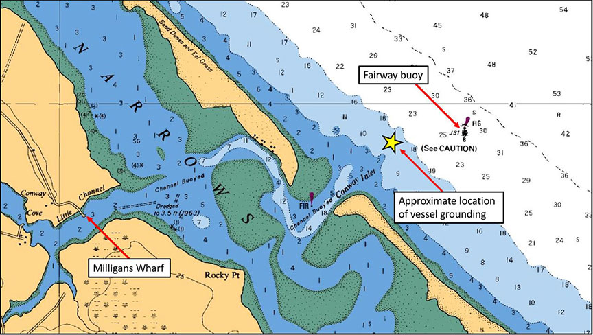
When the vessel departed at 1100 for its 2nd trip, visibility was good, the tide was ebbing, the winds were northeasterly at 10 to 15 knots, there were swells of 1 m to 2 m in height, and some white water was visible near the JS-2 and JS-3 channel buoys. Masters of other fishing vessels who had navigated Hardys Channel earlier that day had reported over very high frequency (VHF) radio channel 80 to pass close to the starboard hand buoys, because water there was deeper than at other locations within the channel (Figure 1).

Once the Roping the Wind entered Hardys Channel, it briefly made bottom contact with a sandbar and the engine slowed. The engine soon recovered, and the vessel continued its voyage until it grounded on another sandbar near the last port and starboard hand buoys in the channel, approximately 1.25 nautical miles northeast of Rocky Point, PEI.
When the master realized that the vessel was hard aground, he immediately switched the control handle to neutral, stopped the engine, and ordered the crew to don their lifejackets. As the crew members donned their lifejackets, a swell from the northeast combined with the ebbing tide turned the grounded vessel to port, exposing its starboard side to the sea.
The master requested help over VHF channel 80, and all crew members moved from the deck onto the vessel’s starboard side washboard, using the vessel’s lobster trap boom for support. Some lobster traps fell overboard as the crew members made their way onto the washboard. The master tried to climb up and over the remaining traps to access the life raft and emergency position–indicating radio beacon (EPIRB) stored on top of the wheelhouse, but was unsuccessful. The vessel began to founder as waves broke over the starboard bulwark.
The fishing vessel Spring Loaded 04 was nearby, and its master positioned it near the Roping the Wind. The crew of the Spring Loaded 04 rescued 3 crew members from the grounded vessel. As other fishing vessels arrived on scene, the Spring Loaded 04 returned to the wharf.
One of the crew members from the Roping the Wind had fallen into the water and was rescued by the crew of the Dustin’s Dream. The crew of the Bounty Hunter 04 rescued the last crew member remaining on board the Roping the Wind.
All rescued crew members were brought to Milligans Wharf, where they received medical attention from paramedics. Four of the crew members, 1 of whom was in critical condition, were taken to hospital where they were treated for hypothermia before being released later that day. The 5th crew member did not require medical attention.
The vessel was recovered later that week by a local salvage company. It sustained severe damage to its wheelhouse and extensive water damage due to flooding. The local salvage company covered the fuel tank vent the day after the occurrence. No pollution was reported.
Milligans Wharf and Hardys Channel
Milligans Wharf is located within Little Channel and is an L-shaped public wharf used by local lobster harvesters. A channel leads through the narrows of Malpeque Bay toward Conway Inlet, and is locally known as Hardys Channel (Figure 1).
Hardys Channel is a buoyed channel that contains 5 starboard hand buoys and 5 port hand buoys; the end of the channel is marked with a JS fairway buoy (Figure 1).
The Canadian Coast Guard’s Aids to Navigation program (CCG Aids to Navigation) and the Fisheries and Oceans Canada (DFO) Small Craft Harbours (SCH) program are the 2 principal entities that manage the navigational aspects of Malpeque Bay. CCG Aids to Navigation oversees the placement of navigation aids to mark the channels within the bay, including Hardys Channel, and is responsible for communicating changes to these aids. The SCH program oversees the regulatory and administrative control of harbours within the bay, as well as operations and maintenance; it is responsible for working with the local harbour authority to determine if dredging is required to provide a safe access to the port.
In order to identify and maintain a navigable channel into Milligans Wharf, the CCG contracts out the placement, lifting and removal, maintenance, and servicing of the buoys in Hardys Channel.Footnote 3
A local fish harvester has bid on and won the CCG contract every year for over 20 years, including the spring of 2018. As soon as conditions allow, and before the start of the fishing season, the contractor takes soundings of the area and, in conjunction with information provided by DFO’s Buoy Data Card,Footnote 4 places buoys to mark the best channel. This was done before the opening of the 2018 fishing season. No guidance is provided to the contractor as to the minimum depth required for this channel. The contractor is not required to share the depth soundings of the channel with any party, and SCH is not made aware of the channel depth before the start of the fishing season. Neither the CCG nor the SCH program take soundings before the start of the fishing season to determine the water depth in the channel.
The contractor tends the buoys throughout the navigation season and may move them to mark the best channel, as needed. The CCG and SCH program rely on the contractor and mariners to report on insufficient water depth. Typically these reports are made following a bottom contact or grounding. The CCG relies on the contractor to report when the buoys have been moved as a result. Once informed, the CCG issues a cautionary notice to shipping (NOTSHIP), which remains in place until the end of the navigation season, and the SCH program takes action as needed.
At the time of the occurrence, CCG Aids to Navigation required that a design and review officer conduct a local site visit every 5 years to assess the aids to navigation throughout the Narrows of Malpeque Bay and Hardys Channel (Figure 2). The last review was conducted in 2008, when it was determined that no revision to the aids to navigation was needed.
The Canadian Hydrographic Services Chart No. 4491 for Hardys Channel does not depict the port and starboard hand buoys marking the channel; rather, the chart tates that the channel is buoyed, indicating that mariners must rely on the buoys in place for the best route (Figure 2).
The chart also includes a warning to mariners, in both English and French, that, due to changes in channel conditions, buoys can move position, and that mariners should not navigate the channel without local knowledge:
CAUTION
Owing to changing conditions, the lights and buoys may be moved to mark the best channel leading into Malpeque Bay. Mariners should not attempt to enter without local knowledge. For subsequent changes to aids to navigation, the Notices to Mariners and the List of Lights, Buoys and Fog Signals must be consulted.Footnote 5
Local fish harvesters are familiar with the constant silting and bottom shifting that can occur within Hardys Channel, and the potential that under-keel clearance can be less than what is required for fishing vessels to safely navigate the channel. At the time of the occurrence, local fish harvesters had already determined that the preferred route in Hardys Channel was to navigate as close to the starboard hand buoys as possible.
Prior to the incident, the last sounding by SCH was done along the channel in 2011. At the time, SCH decided, in accordance with its Harbour Accommodations Guidelines for Small Craft Harbours Branch,Footnote 6 that dredging was unnecessary because the channel was deemed deep enough for safe navigation. Historically, dredging has not been required in this channel; it was last dredged in 2004.
According to these guidelines, when the water depth in any channel under the authority of the SCH program is less than 1 m, the SCH program begins to closely monitor the water depth within the channel and communicates regularly with the harbour authority. If the channel meets the threshold for dredging (approximate 0.7m depth), the SCH program arranges for a survey to be carried out, and Public Services and Procurement Canada issues contracts for dredging when required. These thresholds for increased monitoring and dredging are not publicly available.
The day after the Roping the Wind ran aground, DFO carried out a sounding survey, and a few areas with less than 1 m of water depth were found. The results of the survey were communicated to the CCG and notices to shipping were published, cautioning local fish harvesters that a fishing vessel was blocking the channel, that the channel was experiencing infilling, and that fish harvesters should navigate with caution.
Tides
On 30 April 2018, there was a full moon. Full moon and new moon phases in the spring produce spring tides, causing significant differences in height between daily high and low tides. The graph below depicts tides at Ellerslie, PEI, which is the reference port for Hardys Channel (Figure 3).
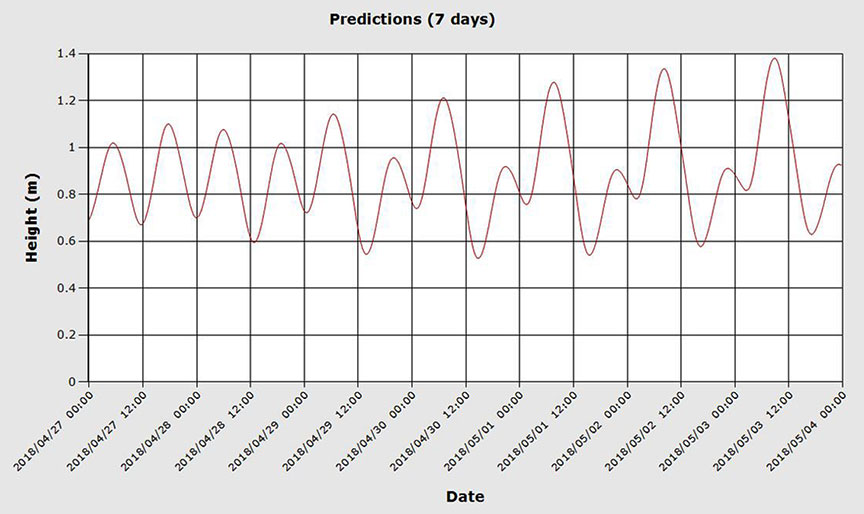
When the Roping the Wind made its 1st trip of the day, there was sufficient water depth to safely navigate Hardys Channel. On its 2nd run, the tide was falling and was lower than the previous low tide. During the outgoing tide, the winds were from the northeast and opposing the tidal current in Hardys Channel, generating large, steep waves.
Safety action taken
As a result of this occurrence, SCH Prince Edward Island Area has taken a new initiative to annually monitor channels to gather information for future decisions, and to be aware of infilling.
Safety messages
The TSB has previously investigated occurrences involving sandbars in the approach to a harbour. In 1 occurrence, the specific location of a newly buoyed channel was not depicted on any chart or otherwise communicated to harbour users.Footnote 7 In 2 other occurrences, the extent of silting and the presence of a sandbar was not communicated to harbour users.Footnote 8
Although fish harvesters are responsible for assessing the risks posed by weather and sea conditions to ensure the safety of their vessels and crews, and caution should be exercised when transiting areas of continuous silting and shifting sand, an accurate assessment cannot be completed in the absence of information regarding navigational hazards and safe passages.
Hardys Channel is buoyed by a local contractor before the start of each fishing season, and the depth soundings are not communicated to the users before the season opens. SCH and the CCG rely on reports from local users on insufficient channel depth after the buoys are placed. SCH had not assessed the condition of the channel or sounded the channel since 2011. Without accurate channel depths before the start of the fishing season, fish harvesters may transit into hazard areas, endangering the safety of their vessels and crews.
This concludes the TSB’s limited-scope investigation into this occurrence. The Board authorized the release of this investigation report on . It was officially released on .