
Marine Investigation Report M98L0097
Grounding
bulk carrier Federal Fraser
Lévis, Quebec
The Transportation Safety Board of Canada (TSB) investigated this occurrence for the purpose of advancing transportation safety. It is not the function of the Board to assign fault or determine civil or criminal liability. This report is not created for use in the context of legal, disciplinary or other proceedings. See Ownership and use of content.
-
Table of contents
Summary
On 2 August 1998, the Panamanian bulk carrier Federal Fraser was calling at the Port of Québec to discharge steel plates at the shipyard. As the vessel was initiating its final approach to Murphy wharf, assisted by a tug and under the conduct of a harbour pilot, it grounded during high tide on a sand shoal southeast of its course.
Factual information
Particulars of the vessel
| Name | "FEDERAL FRASER" |
|---|---|
| Official Number | 25571-98 |
| Port of Registry | Panama |
| Flag | Panama |
| Type | Bulk carrier |
| Gross TonsFootnote 1 | 22 388 |
| Length | 222.54 m |
| Draught | Forward: 7.60 m Aft: 7.50 m |
| Cargo | 22 941 tonnes of steel plate |
| Built | 1983, Glasgow, Scotland |
| Propulsion | One Sulzer 4RLB76 diesel engine; 8003 kW |
| Crew Members | 22 |
| Owner | Prominent Star, Hong Kong |
The Federal Fraser is a bulk carrier with its bridge, accommodation, and engine room located aft of the seven cargo holds. With a deadweight capacity of 35 315 tonnes, this ocean-going vessel is of maximum dimension for the St. Lawrence Seaway. It is fitted with a bow thruster to facilitate docking and departure.
History of the voyage
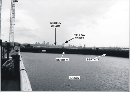
On August 1, at approximately 2242Footnote 2, the Federal Fraser dropped anchor at Québec harbour anchorage "D", waiting to unload 1135 steel plates at the shipyard's Murphy wharf at Lévis. The Québec Port Authority identifies this wharf as berth No 73.
The vessel weighed anchor on August 2 at approximately 0130. On the bridge were the master, the officer of the watch, a helmsman, and a harbour pilot conducting the vessel visually. At 0142 the pilot advised Marine Communications and Traffic Services (MCTS) that the vessel was leaving anchorage "D" to approach the shipyard entrance. At 0146 the tug Ocean Bravo was secured by the bow, forward of the accommodation on the starboard side. The weather was clear and no traffic was in the area.
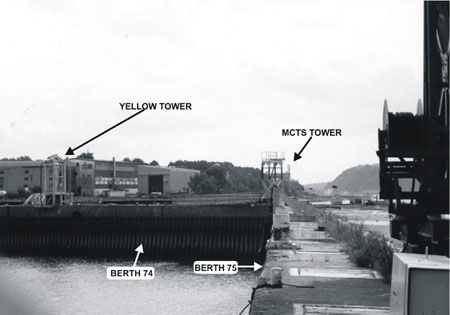
The vessel steered towards the basin by completing a turn in the St. Lawrence River waterway. In the approaches to the shipyard, the vessel was steered for north of the mole of wharf No 75, and when the face of the wharf was visible, the pilot ordered the helmsman to steer a course of 225° G. Drifting southeast, the pilot aligned the vessel with a yellow tower at the back of the basin and the MCTS radar tower in Lévis. The approach manoeuvre was carried out at an approximate speed of one knot. The chief officer on the forecastle informed the master that the vessel's bow was about 40 m from the entrance to the dock. A little later, he reported a distance of about 30 m.
At about 0200 the shipyard staff assigned to moor the vessel observed that the vessel had stopped about 75 m off Murphy wharf.
At 0202 the main engine was stopped, put to full astern, and then half astern. At 0215 the pilot noticed that the vessel ran aground. Then, at 0218, the main engine was stopped. At 0225 the pilot asked about the water level via his cellular telephone. The MCTS marine traffic regulator informed him that the tide gauge measured the water level at 3.98 m. The speed was changed from full astern to full ahead, but the vessel slowly swung round on itself. When the speed was increased again to full ahead at 0310, the vessel remained dead in the water. Thus, navigating personnel concluded that the vessel was aground. The radar indicated a distance of 0.15 nautical miles from the mole of Murphy wharf.
At 0312 the Ocean Bravo pushed against the vessel's port side in an effort to free it. An inspection of the compartments did not reveal any water ingress. At 0405, with the assistance of the tug, the Federal Fraser swung to starboard and then refloated. It was then decided to return to the anchorage. At 0445 the pilot advised MCTS that the vessel was back at anchorage "D".
In a second attempt, on August 4, the Federal Fraser docked at Murphy wharf without further incident. This time, assisted by two tugs, the approach to the basin was made during high tide by aligning the vessel with the mole of berth No 75.
Damage to the vessel
Soundings of the compartments conducted after the occurrence did not reveal any water ingress. On August 5, as the vessel was moored at Murphy wharf, an underwater inspection was performed along the port bottom plating. The inspection revealed the presence of scoring on the bilge strake and the adjacent bottom strake between frames nos 213 and 225 under hold No 2. A second concentration of scoring was observed in way of the transverse bulkhead between holds nos 2 and 3 on the bilge and bottom strakes between frames nos 186 and 196. According to the underwater inspection plans, this damage is located between about 30 m and 75 m from the vessel's bow.
Weather and Current Conditions
On August 2 the following weather conditions were recorded in the bridge log book of the Federal Fraser: light wind, partly overcast sky, and a temperature of 16°C.
According to the Department of Fisheries and Oceans (DFO) Atlas of Tidal Currents, during high tide, the current arrow off Murphy wharf indicated a current of 1.12 knots in an estimated direction of 280° T. However, after the change of tide, the current overturned and then flowed eastward.
According to the DFO Canadian Tide and Current Tables, on August 2 the predicted height and time of high tide were 4.1 m at 0200 eastern daylight time. The tide gauge recorded high tide at approximately the same time but as 3.9 m high.
Nautical Charts and Bathymetric Surveys
Before boarding, the pilot had consulted his copy of CHS chart No 1316 at his home.Footnote 3 Pilots are responsible for updating their nautical charts and his was, to his knowledge, up to date.
Any local authority, company, or person wishing to carry out works in the navigable waters of Canada must apply to DFO, Navigable Waterways Protection Division (NWPD), for approval. However, if a survey is produced which does not follow work such as construction, dumping, or excavation, the person or organization conducting the survey is not required to inform the NWPD of the survey results. The NWPD has an information/data-sharing agreement with the CHS.
The shipyard received an excavation-of-materials permit from the Navigable Waterways Branch of Transport Canada (now the NWPD of DFO) in 1992. A copy of the post-dredging survey, dated 5 July 1992 and entitled Ent. Normand Juneau inc, No 92-004, was sent to the CHS.
In 1996 the shipyard carried out a private sounding of the basin and its approaches to assess the water depth available for docking drilling platforms. The bathymetric survey (dated 25 June 1996, entitled BPR No AO-E03-9600-X-001) was produced and distributed to the appropriate departments of the shipyard. However, no excavation was done and no copy of this survey was forwarded to NWPD or, consequently, to the CHS. The shipyard did not forward a copy of the survey to the CHS directly.
A data-sharing agreement also exists between the CHS and port authorities. If the works lie within the limits of a port over which the port authority has jurisdiction, the authority will inform the CHS directly of any change in survey results. However, this agreement does not apply to a private area in a port. The shipyard is located in a private area of the Port of Québec, and there was no procedure requiring the shipyard administration to submit its new bathymetric surveys to the Port of Québec Corporation.Footnote 4 Consequently, the results of the 1996 bathymetric survey were not forwarded to the harbour master's office.
At the time of the occurrence, the shipyard had two bathymetric surveys showing the bottom contour near the yard, but the Port of Québec Corporation and the Corporation des pilotes du Bas Saint-Laurent were aware of only the 1992 bathymetric survey. Before going on this assignment, the pilot had consulted a copy of this survey. He was unaware of the existence of the 1996 survey.
When the CHS receives a bathymetric survey produced by the private sector, it verifies the parameters used to produce the document, such as chart datum and references. If the survey is not conducted according to CHS criteria, the verification process is more complicated. Private sector soundings and surveys are not subject to a CHS quality control program.
Charted depths are maintained by sounding and dredging navigable waterways. The frequency of this work is determined by the historical assessment of needs and special demands. There were no CCG plans to conduct soundings in the approaches to the shipyard in 1998. Further to the grounding, the CHS conducted such soundings in September 1998. In November 1998, the CHS produced a bathymetric survey of the area entitled Quai de MIL Davie Lauzon, No 321/1018.
Available Water Depth
CHS chart No 1316 shows a shoal on the eastern side of the basin entrance. Both the 1992 and 1996 bathymetric surveys show that the shoal extends westward. Notship 127/98 indicates that in July 1997, a 3.2-m ridge was discovered in the western part of this shoal. The 1998 survey also detected the presence of a new ridge, 3.8 m deep, on the west side of the shoal. This ridge, with an area of about 200 m2, lies north of the 3.2-m ridge and the 5-m isobath and is about 75 m north-northeast of the mole of Murphy wharf. There is no notice warning of silting on CHS chart No 1316.
At about 0200 on August 2, the Québec tide gauge trace indicated a water level of 3.9 m above chart datum. The tide gauge trace showed that the actual time and height of high tide were consistent with those forecast, i.e. 4.1 m. The pilot indicated - and the tide gauge trace confirmed - that, after high tide, the water level fell more quickly than expected. When the vessel refloated at about 0400, the water level had fallen to 3.05 m.
With a maximum draught of 7.6 m and a water level ranging between 4.1 m and 3.05 m, the Federal Fraser would strike any shoal over which it passed which was less than 3.5 m deep. CHS chart No 1316 shows a limiting depth of over 3.7 m on the direct approach to Murphy wharf from the river. According to the vessel's bell book, the depth was 6.3 m at 0240 and 3.8 m at 0317.
Aids to Navigation
Navigators, including pilots, use land topography to conduct ships visually. Among the features charted by the CHS, there are natural features, cultural features, and landmarks. The CHS inventories and chooses which landmarks to chart.
To align the vessel with the mid-point of the basin, the pilot used, in the background, the MCTS radar tower and, in the foreground, a yellow tower on berth No 74.
The CHS does not have a list of landmarks used by pilots in the area. Some features useful to pilots are not charted by the CHS. At the time of this occurrence, the CHS had not received a request to chart the position of the yellow tower on its chart No 1316.
This yellow structure was used to carry power supply lines to the General Georges P. Vanier floating dry dock. This 7.17-m high tower stands 67.3 m and 36 m from berths Nos 73 and 75, respectively. However, a prominent feature, the floating dry dock, was charted even though it was no longer at the shipyard. No mariner had advised CHS of this change.
A group of communication radio towers located west of Fort No 1 at Pointe de Lévy are used by navigators as landmarks. The pilot used one of these towers abeam to judge the vessel's movement. In the foreground, he observed the shipyard's cranes; in the background, he noticed the 76.2-m VHF tower, which was illuminated.
Although these towers were listed by the CHS, their number and location have changed over the years. The CCG surveyed the new installations after the changes, but this information was not submitted to the CHS. The DFO Technical Services Branch limited its verification of radio telecommunication towers to the towers' radio-electric performance. At the time of the occurrence, the positioning of the radio towers on the chart was not subject to the degree of precision inherent in the CHS verification process of some landmarks known to be used by navigators.
Participation of Navigating Personnel
Before departing from anchorage D, the pilot informed navigating personnel of the route that he intended to follow and stated the subsequent mooring manoeuvre he would execute. At 0220 an entry was made in the bridge logbook that the vessel was awaiting a favourable tide to enter the basin. Further entries were made in the vessel's bell book concerning speed changes until 0310, when the vessel was logged as having come to a stop.
Tug Assistance
The number of tugs used for the approach and docking manoeuvre at Murphy wharf was left to the discretion of the master and the shipping agent . As the vessel was fitted with a bow thruster, all agreed to the use of one tug.
Approach Manoeuvre
The pilot conducted the vessel visually using the landmarks with which he was familiar. During the approach, the pitch of the propeller was reduced to 1.5 to reduce the vessel's speed.Footnote 5 To stem the current and drift to the southeast, the pilot engaged the bow thruster and ordered the tug to push against the vessel's aft starboard side. The pilot estimated that he followed a route south of the 7.6-m and 5.9-m soundings at the entrance to the basin. The crew observed minimal sideways drift in the final phase of the approach.
Reporting of the Grounding
Neither the pilot nor navigating personnel informed MCTS of the grounding before the vessel was refloated. The pilot had access to VHF radiotelephones and a portable radiotelephone on the vessel, but he used his cellular telephone to ask MCTS about the water level. Upon returning to anchorage "D", the pilot used a VHF radiotelephone to report his position to MCTS. The conversation was limited to when the next attempt would be made to dock at the shipyard. It was not until the pilot requested the services of a pilot boat by cellular telephone that he confirmed to the Pilot Dispatch Centre attendant that the Federal Fraser had been aground.
Although the MCTS regulator maintained a VHF radiotelephone watch as well as a radar and visual watch, he did not notice that the vessel remained motionless for about two hours. In the morning, the Corporation des pilotes du Bas Saint-Laurent confirmed the occurrence, and the Pilot Dispatch Centre advised the MCTS supervisor. At about 1010 a regulator radiotelephoned the crew to obtain information about any damage to the vessel and to check whether there had been any pollution.
Analysis
Nautical Charts and Bathymetric Surveys

Comparison of the bathymetric surveys of 1992, 1996, and the post-occurrence survey of 1998 showed that, over the years, the edge of the shoal at the entrance to the shipyard basin has extended westward as a result of silting (see Figure 1). In keeping with good seamanship, navigating personnel and the pilot chose to use the largest-scale chart as a reference. However, this chart did not bear any notice or warning concerning silting off the shipyard.
Although bathymetric surveys provide more detailed depth information than nautical charts, they are not normally used for navigation. They are usually intended for those who monitor the depth of navigable waters. A note to this effect was included on most of these documents. However, the pilot took into account the 1992 survey in his manoeuvring. As the shipyard had not submitted the 1996 survey to the CHS, neither the pilot nor the CHS had consulted it. It seems that there are no standards for the submission of bathymetric surveys performed by the private sector if no construction, dumping or excavation work is done.
The accuracy of bathymetric surveys depends on several factors related to sounding and survey quality. When the sea bed is subject to constant silting, surveys only represent the actual sea bed at the time of the soundings. Neither the 1992 nor the 1996 bathymetric survey showed the presence of the 3.8-m ridge. As no nautical chart or bathymetric survey available indicated the presence of this ridge, navigating personnel and the pilot could not accurately assess the available depth under the vessel's keel near the approaches to the shipyard.
Choice of Navigation Aids
As the weather was clear, the vessel was conducted visually. The pilot chose to use as visual cues the MCTS radar tower and the yellow tower at the end of the basin. As the CHS had not received any notice from pilots that the yellow tower was used as a landmark, it had neither listed nor charted it. Furthermore, the tower is not located at the centre of berth No 74, but northwest of that position. Accordingly, the alignment that it forms with the MCTS tower runs northwest of the centre of the basin's entrance in the approaches. Examination of the alignment shows that the lateral error 200 m from the basin's entrance is about 15 m. As a result, the alignment gives the navigator only an approximation of the vessel's approach track.
To assess the vessel's way, the pilot observed the radio towers in way of Fort No 1 at Pointe de Lévy. Although the transverse visual cues were less crucial in determining the vessel's position, their location and number differ from what is shown on CHS chart No 1316. Discussions with the DFO Technical Services Branch revealed that there was no mechanism to advise the CHS of any positional or physical change to these radio-electric installations. The change in the location of the towers is not a factor that contributed to the grounding, but it could jeopardize safety in other instances.
The CHS endeavours to present information useful to mariners, but some charted landmarks are more useful than others. Charted features are not all plotted with the same level of accuracy. At the time of this occurrence, the mechanism for exchanging information with navigators, including pilots, did not appear to bring about the desired outcomes. Although there are no standards governing the choice of landmarks to be charted, the participation of the marine industry in making its requirements known could improve the quality of such choices.
Approach Manoeuvre
The method used in approaching Murphy wharf can vary from pilot to pilot. The pilot on duty chose a manoeuvre that he had used in the past, which he hoped would minimize the unexpected and increase safety. He planned to approach the mole of berth No 75 and drift transversely towards the centre of the basin and then drift again transversely towards Murphy wharf.
Nothing suggests that the drift produced by the vessel's bow thruster and the tug was not under control. Before grounding, the vessel was making slow headway while drifting transversely to the south area. At about 0215, the pilot noticed that the vessel was motionless; he must have concluded that it had made contact with the sea bed.

The underwater inspection showed that the damage was confined to the bottom plating, especially in way of the port bilge strake. It may be concluded from this damage that the vessel was moving transversely when it struck an object on its port side.
The 3.8-m ridge is the only object northwest of the 5-m isobath and southeast of the vessel's course (see Figure 2).
With a water level ranging from 4.1 m to 3 m during the grounding, this ridge was most probably the object that the Federal Fraser struck. It is conceivable that the depth of water over the ridge was less than or equal to 3.5 m before the vessel's impact and that the depth over it increased to 3.8 m as a result of contact with the vessel.
Based on the distance measured by radar, 0.15 nautical mile (278 m), and the estimated distance of 200 m between the bow and the radar antenna, the vessel's bow would have approached within about 78 m of the mole of Murphy wharf. An examination confirmed that the ridge is about 75 m from Murphy wharf. The contact of the stem with the shoal would have been sufficient to check and then stop the vessel. The information from ship sources and yard employees' observations confirm that the vessel stopped moving around 0200 about the same distance off the wharf.
The subsequent manoeuvring speed changes caused the vessel to advance farther onto the ridge. As the water level fell, the hull's weight on the ridge would have caused scoring on the plating. The scoring between 30 m and 75 m from the bow confirms the 30 m and 40 m distances reported by the chief officer.
The approximate position of the grounding in way of the 3.8-m ridge shows that the vessel had drifted southeast of the alignment of the radar and yellow towers and that she was lined up approximately in the centre of the basin as reported.
Navigating personnel did not use the parallel index technique on one of the radars. A voyage plan using this radar technique could have enabled the navigators to safely determine the vessel's alignment and distance off the shoal without having to plot positions on the chart. Had the yellow tower been charted, the alignment of the yellow tower with the radar tower could have been on the radar screen, and parallel indexing could have been employed. On this alignment, the vessel would have entered the basin without striking the 3.8 m ridge. Without this yellow tower, navigating personnel could have used the mole of the Murphy wharf.
Bridge Resource Management
A crew sailing in foreign waters generally has little local knowledge. As a result, navigating personnel tend to let the pilot assume entirely the conduct of the vessel. Because the ship's navigating personnel were not actively involved in the vessel's navigation in the approach to the basin, they did not realize that the vessel had run aground until well after the fact. Although the vessel did not lose its watertight integrity, the initiation of shipboard damage assessment measures was delayed.
Although the pilot had talked about the manoeuvre he intended to execute, this occurrence shows that, at the time of the grounding, full and complete participation was not established between navigating personnel and the pilot. To ensure a safe approach, exchange of information among bridge team members must be continuous.
Reporting of a Marine Occurrence
The MCTS Centre should be advised of marine accidents promptly. The Centre is the point of contact for organizations responsible for initiating emergency measures. Such organizations, like the DFO and Transport Canada, are mandated to, inter alia, protect the environment and ensure the seaworthiness of vessels.
VHF Radiotelephone Practices and Procedures Regulations set out the navigation safety call measures to be undertaken to inform MCTS and other mariners operating in the area in order to promote safe navigation after an occurrence takes place. Operational radiotelephones were available for making a navigation safety call, but were not used. Because MCTS was not informed of the grounding, the implementation of shore-based and shipboard damage assessment measures was delayed. In addition, mariners transiting the area were unaware of information that could have affected their navigation.
The Federal Fraser was visible from the MCTS Centre; it was on the radar screen, but the vessel's return to the anchorage after the failed attempt to dock did not arouse the marine traffic regulator's curiosity. Having been informed of the occurrence, the regulator did not obtain all relevant information as set out in the MCTS operations manual. While not all responsible organizations were required in this occurrence, not acquiring relevant information as soon as possible can cause critical delays in the provision of emergency services.
In this instance, the pilot and navigating personnel were not aware of the mandated responsibilities that certain government departments must undertake after being informed of a marine occurrence by MCTS, and thus did not report the occurrence to the MCTS.
Findings
Findings as to causes and contributing factors
- Sound bridge resource management practices (i.e. the full and complete cooperation necessary for a safe approach) was not established between the vessel's navigating personnel and the pilot. Communication between navigating personnel and the pilot was interrupted, and position fixing methods, such as radar parallel indexing, were not employed to determine the ship's position.
- On approach to Murphy wharf, the pilot utilized, as a beacon range, an uncharted feature that did not support visual fix plotting on CHS chart No 1316. This choice increased the possibility of navigational error.
- Neither the vessel's navigating personnel nor the pilot had access to a 1996 privately-contracted bathymetric survey which confirmed the presence of silting. The newly formed 3.8-m ridge on which the vessel ran aground was detected during a post-occurrence sounding.
Findings as to risk
- Since the 1996 private bathymetric survey was not subsequent to works, such as construction, dumping, or excavation, the results were not required to be forwarded to the Navigable Waters Protection Division and were not available to navigators.
- The 1996 bathymetric survey was conducted for operating purposes; since the shipyard is located in a private sector of the port, there was no obligation to report changes to the local port authority.
- At the time of the accident, the mechanisms for the exchange of information between CHS and navigators, including pilots, were not generally known. The CHS had not been informed of all landmarks used by pilots and thus, it could not prioritize the selection of landmarks to be charted in order to facilitate the safe passage of vessels in restricted waterways.
Other findings
- Immediately following the vessel's grounding, neither navigating personnel nor the pilot utilized a maritime radiotelephone to transmit a navigational safety call or to report the accident to MCTS. Not doing so resulted in delays in notifying shore-based responsible organizations for conservation of the environment.
Safety action
Action taken
Following the grounding, the Corporation des pilotes du Bas Saint-Laurent asked DFO to conduct a survey of the approaches to the shipyard. On 18 September 1998, the CCG conducted soundings. On 30 November 1998, the CHS produced the bathymetric survey entitled Quai de MIL Davie Lauzon, No 321/1018.
After learning that the number and positioning of the radio communication towers located west of Fort No 1 at Pointe de Lévy had changed, the DFO Technical Services Branch, Laurentian Region, amended its policy so that any changes to its property will be made known to the CHS.
In 1999 the shipyard awarded a contract for a full bathymetric survey of the shipyard approaches. According to the Navigable Waters Protection Division of the Marine Program Branch at the Department of Fisheries and Oceans, no dredging activity was conducted in the area of the grounding.
In December 1999, the TSB issued two marine safety information (MSI) letters dealing with the shortcomings identified during the investigation. MSI 03/1999 deals with the failure to report the grounding of the Federal Fraser and to use a VHF radiotelephone; MSI 04/1999 informs the CHS of the shortcomings concerning the unreported shoal, the non-standard 1996 bathymetric survey, the use of uncharted landmarks, and the failure to report features used by pilots for navigation.
CHS took action in connection with the note on CHS chart No 1316 regarding the silting for the shipyard area. In June 2001, CHS produced this note which was later published on CHS chart No 1316.
CHS is proposing to also include, in its 2002 agenda, formal meetings with industry and the St. Lawrence pilotage organizations in order to determine their requirements and improve quality control with respect to information exchange mechanisms so that useful navigation information may be better presented and thus, expected outcomes may be obtained.
This report concludes the Transportation Safety Board's investigation into this occurrence. Consequently, the Board authorized the release of this report on .
Appendices
Appendix A— Sketch of the Occurrence Area

Appendix B— Photographs
Appendix C— Glossary
- C
- Celsius
- CCG
- Canadian Coast Guard
- CHS
- Canadian Hydrographic Service
- DFO
- Department of Fisheries and Oceans
- G
- gyro (compass course, heading, or bearing)
- m
- metre
- MCTS
- Marine Communications and Traffic Services
- NOTSHIP
- notice to shipping
- t
- tonne
- T
- True
- TC
- Transport Canada
- TSB
- Transportation Safety Board of Canada
- VHF
- very high frequency
- °
- degree